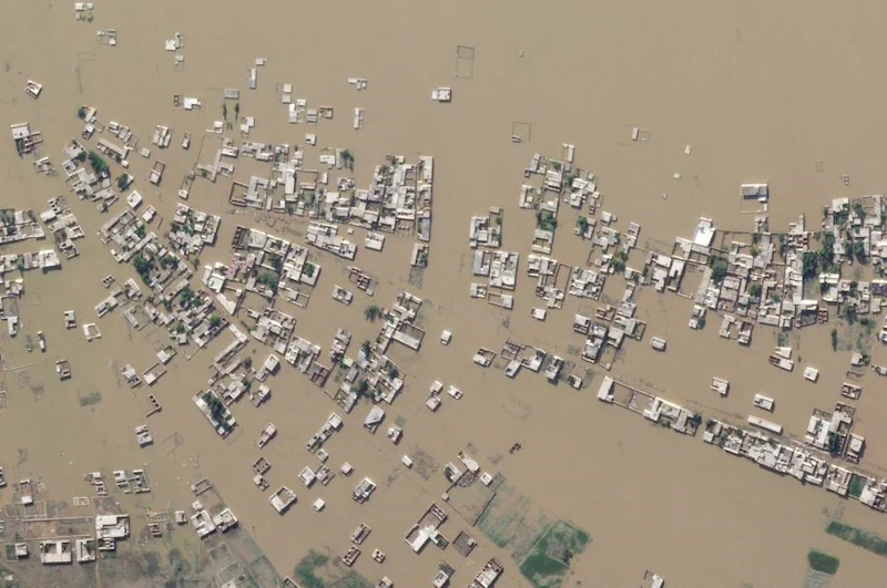
Climate change intensifies disasters, which drives displacement. That can, among many impacts, push internally displaced people from rural areas into urban slums. That in turn raises the risks of forced evictions and secondary urban displacement, as well as increased risks of public health crises, and so on, in a dispiriting causal chain. Knowing, in detail, where people are located is foundational to breaking that chain, by illuminating what risks communities face; targeting efforts to mitigate those risks as they intensify; and ensuring effective humanitarian action when crises strike.
That’s exactly the aim of a new collaboration between Planet, Microsoft’s AI for Good Lab and the Institute for Health Metrics and Evaluation (IHME) at the University of Washington. Together, we’re using satellite imagery, AI and spatial demography to develop high-resolution, comprehensive, and up-to-date population maps, starting in low-resource/high-climate-stress countries. The resulting maps can be used to help model exposure to climate-linked migration risks, food insecurity, disease burden, and many other contemporary hazards.
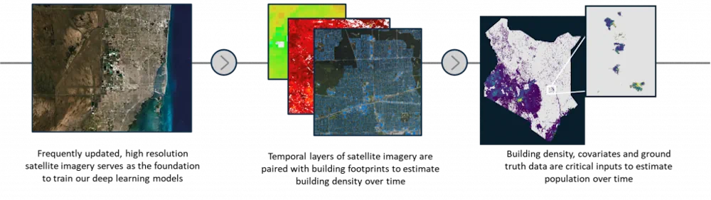
The work begins with the collection of comprehensive data from Planet’s Dove satellites, which image the terrestrial land-mass of the Earth nearly every day. This data is assembled into high-quality, high-recency, cloud-free basemaps at 4.7m/pixel resolution, which are then used for subsequent analysis.
Once collected, the team at Microsoft’s AI for Good Lab run machine-learning models on Planet’s quarterly basemaps – 52 trillion pixels for each year of data – to create building density maps, over time, at a ~40m/pixel resolution. The models are trained on samples of precise building footprint labels from across the globe, leveraging work from the SpaceNet7 competition, weak footprint data from the Microsoft building footprint dataset, and hard negative samples from an internal labeling pipeline. The resulting dataset encodes where structures are globally, and how the density of such structures have changed since late 2017, in a way that can easily be used in gridded spatial models.
IHME then uses the building density data as part of its ongoing global modeling efforts to understand health and the determinants of health in every part of the world. This effort includes highly detailed national census data, survey and administrative data, as well as predictors like lights at night, distance from major roadways, fresh water sources, urban/rural classification, and other climate factors. IHME constructs a geostatistical model of the count of people per human structure. This foundational model allows researchers to predict the distribution of population directly from changes in human structures.
The result is an up-to-date, high-resolution population map that has enormous value for civil government applications, from planning and undertaking a census, estimating budgets for service delivery, citing infrastructure like roads, schools, hospitals and sanitation facilities, and more.