A new data platform from CTrees, REDD+AI, is the first to measure forest degradation from logging, fire, and road construction across all tropical forests. Enabled by artificial intelligence and advanced satellite data, the system detects change in every 5-meter area of tropical forests worldwide.
Forest degradation refers to activities that cause loss of trees, carbon, and other ecosystem services, without complete clearing of the forest. Degradation activities include illegal and legal logging, with a variety of intensities across the tropics, edge effects from forest fragmentation, fire that spreads into forests from nearby land clearing and deforestation, and construction of roads and trails into intact forests, often for logging activities, transportation, and extraction of forest woods and other commodities.
The data show that in 2017 to 2023, human activities like logging, fire, and road construction degraded an average of more than 6.9 million hectares of tropical forest per year. Last year saw the highest levels of forest degradation in the seven years studied, with almost 8 million hectares degraded. In the last six years, human activities have degraded an area of tropical forests equivalent to the size of California.
Reducing deforestation and forest degradation in tropical forests has been a core concern for governments seeking to address biodiversity loss and climate change. Parties to the UN Convention on Biodiversity are gathered this week in Cali, Colombia for COP16, and governments will meet next month in Baku, Azerbaijan, for the COP29 climate conference. Record forest fires occurring across the Amazon basin this year have highlighted the vulnerability of tropical forests to human activities.
REDD+AI significantly enhances the ability to detect previously hidden land use changes such as logging and roads, improving governments’ capacity to monitor and respond to threats in carbon-dense and biodiversity-rich tropical forests. The REDD+AI model tracks changes on a monthly to biannual basis. On the platform, data are visualized on an annual basis. Data available for download show monthly or biannual totals for different drivers for any jurisdiction, providing unprecedented temporal detail about changes occuring in tropical forests.
“Protecting tropical forests is essential for our response to climate change,” said Sassan Saatchi, CTrees’ CEO and senior research scientist at NASA Jet Propulsion Lab/Caltech. “This is the first dataset of its kind to precisely reveal where and to what extent forest degradation, the second “D” in REDD+, is occuring, enabling a more comprehensive strategy for emission reduction. REDD+AI identifies where fire and logging are causing forest loss of carbon multiple times a year across tropics. Until now, only Brazil has had a system to monitor degradation. Our new product gives every tropical forest government the data needed for accountability and action.”
Additional findings from the data include:
Logging is the biggest driver of tropical forest degradation, affecting an average of 4.6 million hectares of forests every year, and making up 67% of total degradation in the study period. Logging in tropical forests can include both illegal tree removal and legal logging in concessions sanctioned by the government.
Forest fire was the second biggest driver, degrading an average of 1.7 million hectares of tropical forest every year, and making up 24% of total degradation. Notably, fires do not occur naturally in the tropics and are typically set by individuals clearing land for agriculture. These fires often spread into intact forests, particularly in areas already stressed by drought.
Each year, approximately 421,000 kilometers of roads are built in tropical forests, roughly equivalent to the length of the United Kingdom’s entire road network. Road construction was responsible for an average of 603,000 hectares of tropical forest degradation annually, making up the remaining 9% of total degradation.
Brazil saw the greatest average annual area of tropical forest degradation, followed by Indonesia, Malaysia, and Bolivia.
In addition to degradation, REDD+AI also measures tree cover loss, defined as areas that have undergone the complete removal of trees, also called clear-cutting, in natural or planted forests. The term ‘tree cover loss' is preferred over 'deforestation' because the latter is generally restricted to the permanent conversion of forest areas to non-forest uses, such as agriculture or urban development and must follow the area definition of forests (> 0.5 hectares), which is 200 times larger than the resolution of REDD+AI. Areas of tree cover loss smaller than the definition of forest may be considered part of forest degradation. REDD+AI may underestimate tree cover loss for years 2017-2020 due to the six-month cadence of NICFI data during this period (the issue does not affect REDD+AI estimates of forest degradation for logging, fire, and road construction).
In 2023, the area of tree cover loss from land clearing in tropical forests was about twice the area of forest degradation. Tree cover loss in 2023 made up 16.7 million hectares, whereas degradation covered 7.9 million hectares.
In Brazil, REDD+AI data show a 27% reduction in tree cover loss in 2023 versus 2022, with 3.4 million hectares of tree cover loss in 2022, and 2.5 million hectares of tree cover loss in 2023. The rate of reduction follows the same tendency as PRODES data, the official source managed by INPE, Brazil's space agency, and used by the Brazilian government for reporting deforestation. PRODES recorded a reduction of 22% in 2023 versus 2022.
The CTrees data is based on images from the PlanetScope satellite constellation, provided by Planet Labs PBC and made available via Norway’s International Climate and Forests Initiative (NICFI). The monthly cadence of Planet NICFI imagery allows CTrees to predict tree cover, logging, fire, and road construction with unprecedented frequency and resolution.
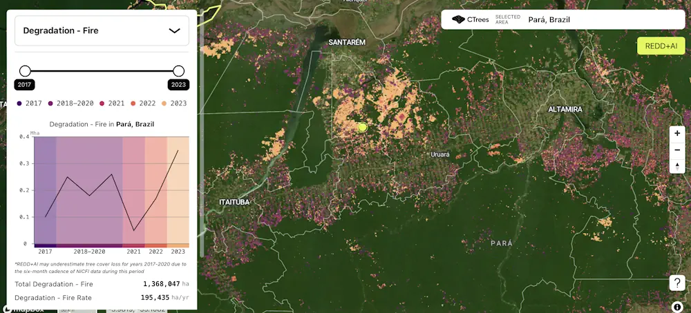
The REDD+AI platform provides open access to maps and statistics of forest degradation for every country and subnational jurisdiction in the tropics. The tool allows users to visualize areas of degradation due to different drivers, and evaluate trends from 2017 to 2023.
REDD+AI uses deep learning to automatically detect tree cover loss and degradation, achieving accuracy comparable to human interpretation. The process is based on peer-reviewed scientific methodologies developed by CTrees scientists Ricardo Dalagnol and Fabien Wagner during postdoctoral research fellowships at UCLA’s Institute of the Environment and Sustainability.
“Training the AI models requires initial visual interpretation and expertise to match imagery to deforestation and degradation in the field, but once trained, it is fairly straightforward to apply it to new images,” said Dalagnol. “In the past, it took interpreters months to analyze and delineate small deforested and degraded areas. Now, with advanced cloud computing capabilities and AI, this can be accomplished across the entire tropics within days.”
“The critical ingredients for this dataset are the high probability of cloud-free imagery available from Planet NICFI data, advanced deep learning models, and CTrees’ big-data cloud computing resources,” said Wagner. “Combined, it gives the only fully deep learning-based product of tree cover loss and degradation in tropics at very high resolution, where each pixel represents an area of around 5m by 5m.”
REDD+AI adds to the open data offered by CTrees to measure change in global forests. Since 2022, CTrees has provided data on carbon stocks, emissions, and removals from biomass on land in every country globally in its Jurisdictional MRV tool. Launched in 2023, CTrees’ Land Use Change Alerts offers alerts every two weeks for deforestation and degradation in forests worldwide.
Future updates to REDD+AI will include more frequent data release, attributions for recovering forests, and detection of change across agroforestry and plantations.
A new data platform from CTrees, REDD+AI, is the first to measure forest degradation from logging, fire, and road construction across all tropical forests. Enabled by artificial intelligence and advanced satellite data, the system detects change in every 5-meter area of tropical forests worldwide.
Forest degradation refers to activities that cause loss of trees, carbon, and other ecosystem services, without complete clearing of the forest. Degradation activities include illegal and legal logging, with a variety of intensities across the tropics, edge effects from forest fragmentation, fire that spreads into forests from nearby land clearing and deforestation, and construction of roads and trails into intact forests, often for logging activities, transportation, and extraction of forest woods and other commodities.
The data show that in 2017 to 2023, human activities like logging, fire, and road construction degraded an average of more than 6.9 million hectares of tropical forest per year. Last year saw the highest levels of forest degradation in the seven years studied, with almost 8 million hectares degraded. In the last six years, human activities have degraded an area of tropical forests equivalent to the size of California.
Reducing deforestation and forest degradation in tropical forests has been a core concern for governments seeking to address biodiversity loss and climate change. Parties to the UN Convention on Biodiversity are gathered this week in Cali, Colombia for COP16, and governments will meet next month in Baku, Azerbaijan, for the COP29 climate conference. Record forest fires occurring across the Amazon basin this year have highlighted the vulnerability of tropical forests to human activities.
REDD+AI significantly enhances the ability to detect previously hidden land use changes such as logging and roads, improving governments’ capacity to monitor and respond to threats in carbon-dense and biodiversity-rich tropical forests. The REDD+AI model tracks changes on a monthly to biannual basis. On the platform, data are visualized on an annual basis. Data available for download show monthly or biannual totals for different drivers for any jurisdiction, providing unprecedented temporal detail about changes occuring in tropical forests.
“Protecting tropical forests is essential for our response to climate change,” said Sassan Saatchi, CTrees’ CEO and senior research scientist at NASA Jet Propulsion Lab/Caltech. “This is the first dataset of its kind to precisely reveal where and to what extent forest degradation, the second “D” in REDD+, is occuring, enabling a more comprehensive strategy for emission reduction. REDD+AI identifies where fire and logging are causing forest loss of carbon multiple times a year across tropics. Until now, only Brazil has had a system to monitor degradation. Our new product gives every tropical forest government the data needed for accountability and action.”
Additional findings from the data include:
Logging is the biggest driver of tropical forest degradation, affecting an average of 4.6 million hectares of forests every year, and making up 67% of total degradation in the study period. Logging in tropical forests can include both illegal tree removal and legal logging in concessions sanctioned by the government.
Forest fire was the second biggest driver, degrading an average of 1.7 million hectares of tropical forest every year, and making up 24% of total degradation. Notably, fires do not occur naturally in the tropics and are typically set by individuals clearing land for agriculture. These fires often spread into intact forests, particularly in areas already stressed by drought.
Each year, approximately 421,000 kilometers of roads are built in tropical forests, roughly equivalent to the length of the United Kingdom’s entire road network. Road construction was responsible for an average of 603,000 hectares of tropical forest degradation annually, making up the remaining 9% of total degradation.
Brazil saw the greatest average annual area of tropical forest degradation, followed by Indonesia, Malaysia, and Bolivia.
In addition to degradation, REDD+AI also measures tree cover loss, defined as areas that have undergone the complete removal of trees, also called clear-cutting, in natural or planted forests. The term ‘tree cover loss' is preferred over 'deforestation' because the latter is generally restricted to the permanent conversion of forest areas to non-forest uses, such as agriculture or urban development and must follow the area definition of forests (> 0.5 hectares), which is 200 times larger than the resolution of REDD+AI. Areas of tree cover loss smaller than the definition of forest may be considered part of forest degradation. REDD+AI may underestimate tree cover loss for years 2017-2020 due to the six-month cadence of NICFI data during this period (the issue does not affect REDD+AI estimates of forest degradation for logging, fire, and road construction).
In 2023, the area of tree cover loss from land clearing in tropical forests was about twice the area of forest degradation. Tree cover loss in 2023 made up 16.7 million hectares, whereas degradation covered 7.9 million hectares.
In Brazil, REDD+AI data show a 27% reduction in tree cover loss in 2023 versus 2022, with 3.4 million hectares of tree cover loss in 2022, and 2.5 million hectares of tree cover loss in 2023. The rate of reduction follows the same tendency as PRODES data, the official source managed by INPE, Brazil's space agency, and used by the Brazilian government for reporting deforestation. PRODES recorded a reduction of 22% in 2023 versus 2022.
The CTrees data is based on images from the PlanetScope satellite constellation, provided by Planet Labs PBC and made available via Norway’s International Climate and Forests Initiative (NICFI). The monthly cadence of Planet NICFI imagery allows CTrees to predict tree cover, logging, fire, and road construction with unprecedented frequency and resolution.
The REDD+AI platform provides open access to maps and statistics of forest degradation for every country and subnational jurisdiction in the tropics. The tool allows users to visualize areas of degradation due to different drivers, and evaluate trends from 2017 to 2023.
REDD+AI uses deep learning to automatically detect tree cover loss and degradation, achieving accuracy comparable to human interpretation. The process is based on peer-reviewed scientific methodologies developed by CTrees scientists Ricardo Dalagnol and Fabien Wagner during postdoctoral research fellowships at UCLA’s Institute of the Environment and Sustainability.
“Training the AI models requires initial visual interpretation and expertise to match imagery to deforestation and degradation in the field, but once trained, it is fairly straightforward to apply it to new images,” said Dalagnol. “In the past, it took interpreters months to analyze and delineate small deforested and degraded areas. Now, with advanced cloud computing capabilities and AI, this can be accomplished across the entire tropics within days.”
“The critical ingredients for this dataset are the high probability of cloud-free imagery available from Planet NICFI data, advanced deep learning models, and CTrees’ big-data cloud computing resources,” said Wagner. “Combined, it gives the only fully deep learning-based product of tree cover loss and degradation in tropics at very high resolution, where each pixel represents an area of around 5m by 5m.”
REDD+AI adds to the open data offered by CTrees to measure change in global forests. Since 2022, CTrees has provided data on carbon stocks, emissions, and removals from biomass on land in every country globally in its Jurisdictional MRV tool. Launched in 2023, CTrees’ Land Use Change Alerts offers alerts every two weeks for deforestation and degradation in forests worldwide.
Future updates to REDD+AI will include more frequent data release, attributions for recovering forests, and detection of change across agroforestry and plantations.