Wildfires present complex socio-economic and ecological challenges, as they devastate vegetation, endanger communities, and cause extensive environmental, wildlife, and human health impacts. These consequences include severe air pollution and soaring firefighting costs.
Wildland-Urban Interface (WUI) areas, which are transition zones between wilderness and human-developed land, are particularly susceptible to wildfires. The risk is heightened due to flammable vegetation and the effects of climate change, such as rising temperatures and frequent heatwaves. Consequently, mitigating wildfire risks has become a global priority.
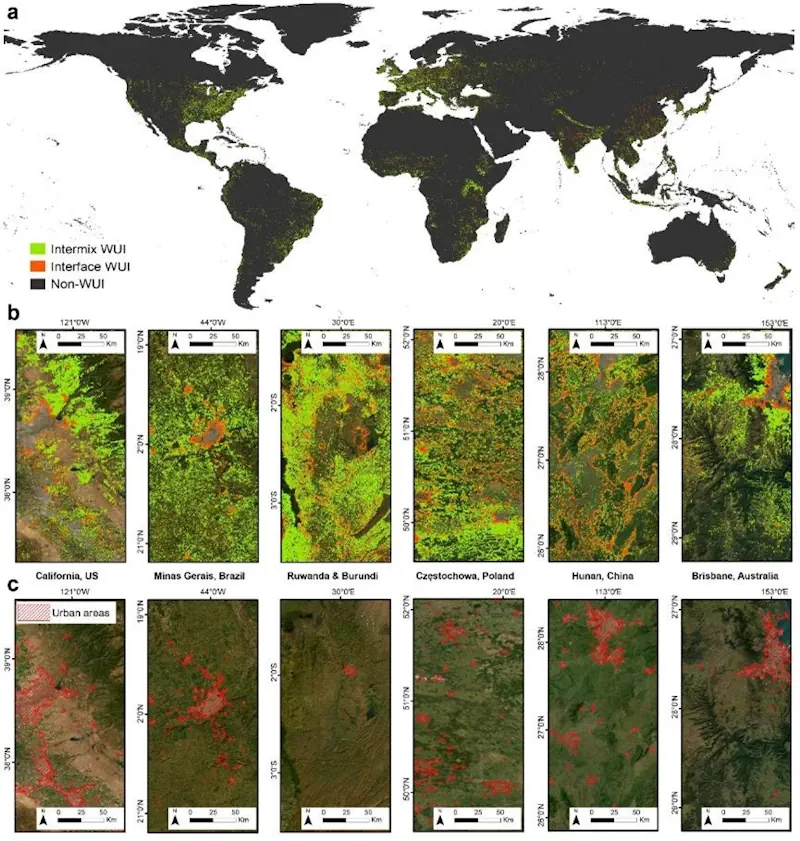
Although WUIs are known to be densely populated by wildfires, there is still a significant knowledge gap regarding their spatial and temporal characteristics, as well as their global wildfire exposure risks. Recently, researchers from HKU, in collaboration with leading interdisciplinary teams from UC Davis, Yale, Utah and Tsinghua, unveiled pioneering mapping results that show a significant surge in global WUIs over the past 35 years (1985-2020).
Published in Nature Sustainability, this groundbreaking research provides reliable, spatially explicit WUI mapping and quantifies WUI – wildfire interaction under climate change. The findings offer essential insights for effective fire management, resilient community development, and global insurance regulations.
The research team has introduced an innovative method for mapping interfaces with crucial human-nature conflicts, using data from Meta for building footprints and data from satellite-derived land cover classification products for wildland vegetation to examine the interaction between houses and nature.
The researchers utilised these detailed and high-resolution data to assess the proximity of buildings to vegetations from 1985 to 2020, revealing the expansive coverage of global WUI areas prone to wildfires, which span a total of 6.62 million square kilometres in 2020. A time-series analysis from 1985 to 2020 also indicates a substantial 12.56% increase of WUIs over 35 years.