Geomaticians

USA

Esri Kooperiert Mit Geneva Demining Centre Auf Dem Gebiet Der Kartierungstechnologie Für Sprengstoffe

Humanitäre Organisationen, die mit der Beseitigung von Landminen und anderen explosiven Kampfmitteln beauftragt sind, verlassen sich zunehmend auf digitale Technologie. Modernes Informationsmanagement dient heute als Grundlage für den Minenräumbetrieb. Um diese Bemühungen zu unterstützen, haben Esri und das Geneva International Centre for Humanitarian Demining (GICHD) ihre Partnerschaft durch ein Memorandum of Understanding (MOU) erneuert und ...
boerse.de

The First Complete Picture Of Arctic Sea Ice Freeze-thaw Cycle Highlights Sea Ice Response To Climate Change

Years of research show that climate change signals are amplified in the Arctic, and that sea ice in this region is sensitive to increases in Arctic warming. Sea ice greatly modifies the exchanges of heat, momentum and mass between the atmosphere and the ocean. So, the timings of the sea ice melt and freeze onsets, ...
eurekalert.org

¡Con Tecnología De La NASA! Plataforma De Senamhi Permitirá Mejorar Pronóstico De Inundaciones

El Servicio Nacional de Meteorología e Hidrología del Perú (Senamhi) anunció el lanzamiento de Senamhi GEOGloWS, una plataforma que cuenta con tecnología de la Administración Nacional de Aeronáutica y del Espacio (NASA). Con los datos obtenidos se espera optimizar el pronóstico de inundaciones a nivel nacional. Este nuevo sistema ha sido personalizado con las condiciones ...
larepublica.pe

Foursquare To Power Geospatial Data Visualization In Amazon SageMaker

Foursquare, the leading independent location technology company, exclusively powers data visualization for the new Amazon SageMaker geospatial capabilities announced last week at Amazon Web Services (AWS) re:Invent 2022. Foursquare Studio can visualize geospatial data at a massive scale with ease, enabling data scientists to explore geospatial data interactively and seamlessly on a map as they ...
businesswire.com

Rutgers Researcher Creates Algorithms To Predict Arsenic Contamination In Private Wells In New Jersey

“New Jersey has many naturally occurring arsenic sources, which can elevate the arsenic concentration in groundwater,” said Subhasis Giri, an assistant research professor in the Department of Ecology, Evolution and Natural Resources and lead author of the study published in the journal Science of the Total Environment. “Our work contributes to the understanding of this ...
newswise.com
New EWG Research Finds Many North Carolina Factory Farms Are At Risk Of Flooding

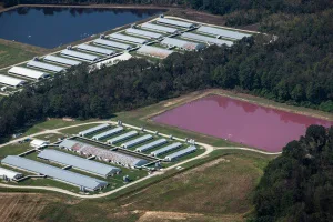
New EWG Research Finds Many North Carolina Factory Farms Are At Risk Of Flooding

A new Environmental Working Group geospatial analysis finds over 2 percent of North Carolina’s 7,352 swine and poultry factory farms are in or just outside floodplains. When these farms flood, they can contaminate water with bacteria and other health hazards. “The 156 factory farms we found in and near North Carolina’s floodplains are at a ...
ewg.org
RIT Researchers Explore How To Improve Emergency Management For The Deaf Community

RIT Researchers Explore How To Improve Emergency Management For The Deaf Community

At Rochester Institute of Technology and the National Technical Institute for the Deaf, a team of researchers is studying how to identify and bridge gaps in emergency management resources and services for the Deaf and Hard-of-Hearing community. Supported by a grant from the National Science Foundation Civic Innovation Challenge, the project is bringing together academic ...
rit.edu
Riegl’s Latest Terrestrial Laser Scanner Is A Fast, Integrated And Versatile System

Riegl’s Latest Terrestrial Laser Scanner Is A Fast, Integrated And Versatile System

Premiered at Intergeo Trade Fair and Exhibition in Germany in October, the Riegl VZ-600i is the company’s latest addition to its terrestrial laser scanning portfolio. The “i” in the product name stands for “integrated” and refers to an integrated second high performance processor that allows for automatic onboard registration of scan data in the field. ...
geoweeknews.com

Satellite Imagery Monitors World’s Largest Active Volcano Eruption In Hawaii

Mauna Loa volcano began erupting in Moku‘āweoweo Caldera on November 27, 2022. A long-feared Mauna Loa eruption has now disrupted several flights and triggered in an all-hands emergency response. As of now there are no mandatory evacuations in place, but shelters have opened to accommodate those opting to leave voluntarily. The eruption comes after months ...
geospatialworld.net

New Device Can Control Light At Unprecedented Speeds

An international group of researchers, led by a team at MIT, has developed a programmable, wireless device that can control light, such as by focusing a beam in a specific direction or manipulating the light’s intensity and doing it orders of magnitude more quickly than commercial devices. Their device, called spatial light modulator, could create ...
techexplorist.com
Geospatial Technology Helps In The Fight Against Environmental Crimes In Brazil

Geospatial Technology Helps In The Fight Against Environmental Crimes In Brazil

The size and complexity of the Brazilian territory, especially in the Amazon region, has historically plagued institutions, like the country’s Federal Police, with challenges around effective response to environmental crimes and illicit activities. To improve their operations, these agencies needed a remote sensing dataset that would complement their field work, allowing them to take timely ...
planet.com

Office Of Policy And Management Announces Launch Of Two Geographic Information System Websites

The Connecticut Office of Policy and Management (OPM) today announced that that the state’s new Geodata Portal and broadband maps will be available beginning on Friday, November 18, 2022. This announcement comes on GIS Day 2022, which helps others learning about geography and the real-world applications of GIS that can make a difference in our ...
portal.ct.gov
Trimble Introduces Innovative Rail Module For Real-time Monitoring Software

Trimble Introduces Innovative Rail Module For Real-time Monitoring Software

Trimble announced today Trimble® 4D Control™ (T4D) software version 6.4, featuring an add-on rail-specific monitoring solution. T4D is a software suite for real-time displacement monitoring and detection. The rail module simplifies the data collection process and reduces up to 95 percent of the office work required to automate movement detection.
amerisurv.com
Satellites Help Scientists Track Dramatic Wetlands Loss In Louisiana

Satellites Help Scientists Track Dramatic Wetlands Loss In Louisiana

From Lake Pontchartrain to the Texas border, Louisiana has lost enough wetlands since the mid-1950s to cover the entire state of Rhode Island. Using a first-of-its kind model, NASA-funded researchers quantified those wetlands losses at nearly 21 square miles (54 square kilometers) per year since the early 1980s. In the new study, scientists used the ...
jpl.nasa.gov
High-Tech Map Promotes Access To Medicine And Pharmacy Services

High-Tech Map Promotes Access To Medicine And Pharmacy Services

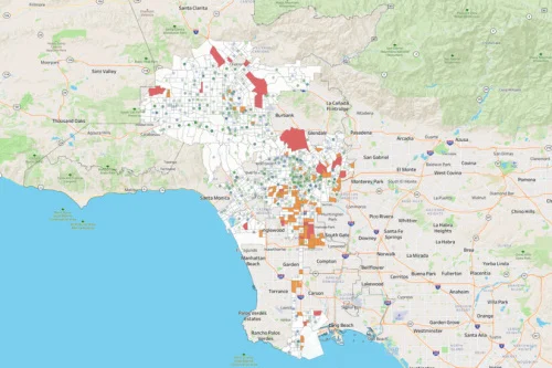
USC’s Dima M. Qato spent more than a decade working as a community pharmacist and public health advocate in underserved refugee and immigrant communities in Chicago. Through her experiences and public health training, Qato — the daughter of a pharmacist and now an associate professor at the USC School of Pharmacy — has come to ...
news.usc.edu
Google Expands AI-powered Flood Detection And Wildfire Systems

Google Expands AI-powered Flood Detection And Wildfire Systems

For the last several years, Google has been using artificial intelligence to develop a system that can predict floods. It has also been working on wildfire tracking tools. Ahead of the COP27 climate conference taking place next week, the company announced that it is expanding those tools. First, Google says it will offer flood forecasts ...
engadget.com
Deep Learning Underlies Geographic Dataset Used In Hurricane Response

Deep Learning Underlies Geographic Dataset Used In Hurricane Response

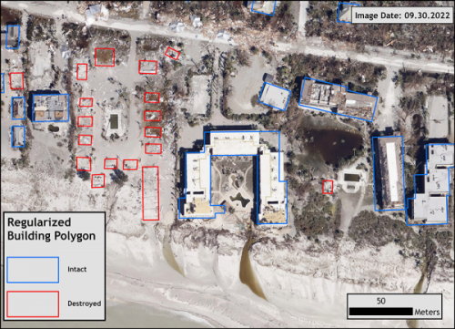
As Hurricane Fiona made landfall as a Category 1 storm in Puerto Rico on Sept. 18, 2022, some areas of the island were inundated with nearly 30 inches of rain, and power to hundreds of thousands of homes was knocked out. Only 10 days later, Hurricane Ian, a Category 4 storm and one of the ...
newswise.com

Study Finds Neighborhood Features Impact Mental And Physical Health For Better Or Worse

Sidewalks, single-lane roads and street signs could all be part of the path to a community’s mental and physical health, for better or worse, according to a new University of Maryland-led study. The research analyzed Google Street View images of diverse regions of the United States to correlate elements of the built environment to health ...
today.umd.edu

High-res Maps Of Entire Polar Regions Provide New Clues For Climate Researchers

A team of researchers led by the University of Minnesota Twin Cities has released four more years of high-resolution imagery data, which has been added to eight years of previous data, to create the most detailed polar region terrain maps ever created. The maps use high-resolution satellite data to show the polar regions in stunning ...
newswise.com
Starlink Satellites Can Be Reverse-Engineered To Create New GPS

Starlink Satellites Can Be Reverse-Engineered To Create New GPS

In 2020, researchers at the University of Texas at Austin — backed by US Army funding — claimed that, with a simple software upgrade, SpaceX’s Starlink satellite mega-constellation could serve as a low-cost backup to traditional GPS. Because the satellites orbit at an altitude of just 340 miles, their signals are stronger at ground level ...
freethink.com
The World's Largest Indoor Mapping Deployment Goes Live At A Leading Home Improvement Store Chain In The US

The World’s Largest Indoor Mapping Deployment Goes Live At A Leading Home Improvement Store Chain In The US

One of the largest home improvement stores in the US has partnered with Pointr, a mapping and geolocation leader, to provide a digital mapping experience inside their mobile app. This is the largest ever deployment of its kind to enable Store Mode experiences that allow shoppers to interact with the store: (1) Lookup the availability ...
prnewswire.com
New Interactive Online Map Shows Needy People Where They Can Get Reliable Food And Resource

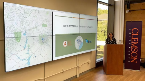
New Interactive Online Map Shows Needy People Where They Can Get Reliable Food And Resources

As many as half a million people face hunger and food insecurity in South Carolina. Now a new tool from Clemson University and the S.C. Department of Health and Environmental Control aims to direct resources to address the problem within local communities. The Food Access Map can direct people to food pantries, community organizations and ...
greenvillejournal.com

Deforestation Follows A Road Through Ucayali

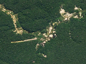
A thin brown line east of the Ucayali River snakes through an expanse of green rainforest in eastern Peru. The road—originally called OX1 and now UC-105—first appears in Landsat satellite imagery in 1987. Landsat images indicate that the surrounding forest stayed mostly intact for more than two decades, despite the activity of oil and logging ...
earthobservatory.nasa.gov

Virginia Tech Researchers Use Artificial Intelligence To Combat Soybean Nematodes

Lurking beneath the soil is something unseen by the naked eye, something so small you need a microscope just to catch a glimpse: nematodes. The tiny organisms are ubiquitous in Earth’s ecosystems and found on the tallest mountains to the darkest corners of the oceans. Often called roundworms, nematodes vastly outnumber other organisms on Earth. ...
morningagclips.com

Mapping The Pressures Of Global Food Production

A map showing the environmental pressures from global food production has been developed by researchers, to identify ways of creating more sustainable and just food systems. The analysis looked at greenhouse gas emissions, water use, habitat disturbance and pollution, such as effluent or fertiliser run off from farms. The study, by the University of Leeds ...
leeds.ac.uk

GIS Leaders Recognized At GIS-Pro 2022

More than 420 GIS professionals recently convened in Boise, Idaho for GIS-Pro 2022, URISA’s 60th anniversary conference. The milestone event was co-hosted by the Northwest GIS User Group and the Northern Rockies Chapter of URISA. During the Awards Luncheon, the 2022 Exemplary Systems in Government (ESIG) Award winners were celebrated. The recipients were announced in ...
directionsmag.com
An Urban Oasis Online Map Identifies Native Trees On Marquette’s Campu

An Urban Oasis: Online Map Identifies Native Trees On Marquette’s Campus

Located in downtown Milwaukee, Wisconsin, Marquette University is an oasis of biodiversity. Most notably, Marquette’s high concentration of Wisconsin-native trees makes the campus a unique space for research, appreciating nature, discovering sacred spaces and more. In 2012, Facilities Planning and Management realized the opportunity Marquette’s campus offers the community and began taking inventory of Wisconsin-native ...
today.marquette.edu

Meet ‘Dreamfusion,’ An Effective AI Technique That Uses Machine Learning To Synthesize 3D Models From Text Prompts

By prompting a text-to-image model we can generate images of a wide variety of objects. With clever prompting, it’s also possible to synthesize different perspectives of a specific object. To use text to generate 3d objects, we start by feeding a caption to a text-to-image model, such as Imagen, adding minor tweaks to the prompt ...
marktechpost.com

Interactive Map Shows Where Metro Thinks Multimodal Improvements Should Be Built

The map of Metro’s Draft Prioritized Active Transportation Network was revealed last week during community stakeholder briefings. In its default view, it shows where bikeways, pedestrian districts, and first-last-mile station improvements are prioritized by the agency. SBLA is calling this the Default Map here, and it’s the cover image above. But the interactive map allows ...
la.streetsblog.org
Researchers Find ‘Significant Rates’ Of Sinking Ground In Houston Suburbs

Researchers Find ‘Significant Rates’ Of Sinking Ground In Houston Suburbs

An analysis of thousands of water and oil wells in the Houston metro area has uncovered significant rates of subsidence, or gradual sinking of the ground, in some of the region’s fast-growing suburbs that have not been previously reported. Shuhab Khan, professor of geology at the University of Houston, led the study published in the ...
eurekalert.org