Geomaticians

USA

Understanding Flood Behavior With Underground Lidar Data

Understanding Flood Behavior With Underground Lidar Data

Mobile lidar scanners are mapping underground spaces in Belfast to better understand and prepare for coastal flooding. The use of SLAM-based systems provides greater clarity of large flood risk areas for surveyors, through the creation of flood models. Globally, lidar solutions help to create the foundations for flood modeling of large areas, however, they seldom ...
geoweeknews.com
Trees Are Moving North From Global Warming. Look Up How Your City Could Change.

Trees Are Moving North From Global Warming. Look Up How Your City Could Change.

As greenhouse gas emissions nudge temperatures higher, trees’ growing ranges are shifting northward, projections from the U.S. Forest Service show. Trees near the southern edge of their geographic ranges — what scientists refer to as “plant hardiness zones” — will be left behind, while northern latitudes will welcome new species from the south. Plant hardiness ...
washingtonpost.com
OpenAI’s Shap-E Model Makes 3D Objects From Text Or Images

OpenAI’s Shap-E Model Makes 3D Objects From Text Or Images

Recently, we’ve seen AI models that produce detailed text-to-video or use run a chatbot on your phone. Now, OpenAI, the company behind ChatGPT, has introduced Shap-E, a model that generates 3D objects you can open in Microsoft Paint 3D or even convert into an STL file you can output on one of the best 3D ...
tomshardware.com
New Startup Nuview Targets Commercial Lidar Satellite Constellation

New Startup Nuview Targets Commercial Lidar Satellite Constellation

New geospatial satellite startup Nuview emerged from stealth mode on Thursday, with plans to build the first commercial LiDAR satellite constellation. A Nuview representative told Via Satellite the company aims to have a 20-satellite constellation, with tentative launch of the first satellites in 24 to 36 months. The company plans to launch satellites in groups ...
satellitetoday.com
Instituto Pereira Passos E Rice University Firmam Acordo De Cooperação Para Enriquecer Atlas Digital Sobre O Rio De Janeiro

Instituto Pereira Passos E Rice University Firmam Acordo De Cooperação Para Enriquecer Atlas Digital Sobre O Rio De Janeiro

O Instituto Pereira Passos, órgão da Prefeitura do Rio, anunciou nesta terça-feira (02/05) um acordo com a Rice University, instituição de ensino superior americana sediada em Houston, para cooperação em cima da plataforma imagineRio, um atlas digital pesquisável que ilustra a evolução social e urbana da cidade ao longo de toda a sua história. Com ...
prefeitura.rio

GeoComm Announces Availability Of School Mapping Solution Designed To Accelerate School Incident Response

GeoComm, provider of Public Safety Location Intelligence®, is excited to announce the availability of GeoComm School Safety, a digital mapping solution which leverages the latest Esri ArcGIS technology to support faster response to school emergencies. The solution provides detailed indoor maps of schools and surrounding grounds, along with critical information needed by school safety authorities, ...
directionsmag.com
ICEYE Announces Beta Release Of Wildfire Data Product

ICEYE Announces Beta Release Of Wildfire Data Product

ICEYE, a provider of natural catastrophe insights, has announced the beta release of its Wildfire Insights product. ICEYE Wildfire uses artificial intelligence and machine learning to provide building-level impact data for wildfires in near real time based on satellite imagery. The product captures data for any wildfire that impacted communities throughout the US, ICEYE said. ...
insurancebusinessmag.com
Map Shows Heartworm Rates Continue To Increase In Hot Spots, New Locations

Map Shows Heartworm Rates Continue To Increase In Hot Spots, New Locations

Incidence of heartworm disease has continued to rise not only in previously known hot spots but also in unexpected locations with previously low heartworm rates, according to the 2022 Heartworm Incidence Map from the American Heartworm Society (AHS). “For many pet owners—and even veterinarians—it can be all too easy to assume that heartworm isn’t common ...
avma.org
Mapping And Health Equity Project Created By UIC Alum, Student Addresses Chicago’s Health Disparities

Mapping And Health Equity Project Created By UIC Alum, Student Addresses Chicago’s Health Disparities

Near the end of the 2019 fall semester, Sonya Gupta was a University of Illinois Chicago undergraduate conducting research on the location and extent of healthcare deserts in the Chicago area and the potential of mobile health clinics to bridge the gap … In the fall of 2020, biological sciences major Ryan Zomorrodi started research ...
today.uic.edu
Nexar Revolutionizes Map-Making With 40x Reduction In Real-time Mapping Costs

Nexar Revolutionizes Map-Making With 40x Reduction In Real-time Mapping Costs

Nexar, the leading real-time mapping company, announced today it has achieved a dramatic 40x reduction in the cost of real-time mapping by leveraging cutting-edge technologies, edge AI, change detection and crowdsourcing. As a result, Nexar’s CityStream Live platform is making real-time mapping data more accessible to the mobility industry than ever before. Nexar dramatically reduces ...
prnewswire.com

Sanborn, An Authority In 3D Models, Pioneers The Digital Twin Base Map

Developed by leading tech firm The Sanborn Map Company (Sanborn), this innovative technology sets a new standard for urban analysis, implementation of Digital Cities, navigation, and planning with a fundamental transformation from a 2D map environment to a 3D environment. Sanborn’s Digital Twin Base Map is a high-resolution 3D map providing reliable mapping information with ...
businesswire.com
A Map Of Every Tree In Africa Will Help Monitor Deforestation

A Map Of Every Tree In Africa Will Help Monitor Deforestation

High-resolution satellite imagery has been used to map every single tree in Africa, demonstrating a technique that could help improve the monitoring of deforestation across the world. Florian Reiner at the University of Copenhagen, Denmark, and his colleagues used images from satellites operated by US firm Planet and machine-learning models to map canopy cover across ...
newscientist.com
Track, Trace And Triumph How Utah Division Of Wildlife Resources And Google Public Sector Are Setting The Standard To Protect The State’s Wildlife

Track, Trace And Triumph: How Utah Division Of Wildlife Resources And Google Public Sector Are Setting The Standard To Protect The State’s Wildlife

Fast forward to 2023, and now Utah DWR officials can get real-time location data for thousands of animals without leaving their office. What’s more, they can overlay today’s location data with up to 20 years of historical information to make data-driven decisions to improve wildlife habitat and populations using the state’s Wildlife Tracker application, running ...
utahbusiness.com
Geographic Technology Provides Landowners With Precise Tools When Making Land Management Decisions

Geographic Technology Provides Landowners With Precise Tools When Making Land Management Decisions

According to Lee Burras and Bradley Miller, agronomists at Iowa State University, advances in geospatial technology coupled with more traditional farming knowledge have allowed researchers and landowners to understand the land more intimately than ever before. Miller, who began his career working in water quality, has seen firsthand how soil can be impacted by the ...
extension.iastate.edu
NOAA Making Vessel Traffic Data More Accessible To Public

NOAA Making Vessel Traffic Data More Accessible To Public

The Automatic Identification System that tracks vessel movements with transponders on ships has helped create an “AIS database of 30 billion-plus vessel locations has become the go-to resource for maritime planners and ocean geospatial tech experts,” according to a recent summary from NOAA. That data is a base for a NOAA website, MarineCadastre.gov . For ...
workboat.com
Cansel Partners With GeoCue To Offer Drone Lidar And Processing Software

Cansel Partners With GeoCue To Offer Drone Lidar And Processing Software

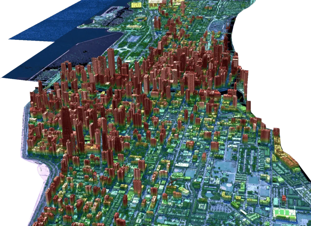
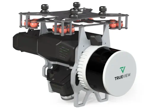
Cansel, a technology solutions provider for industries including engineering, surveying, construction, and utilities, announced a partnership with GeoCue, a global provider of 3D LiDAR imaging sensors and geospatial software. Now as a distributor of GeoCue, Cansel will offer the full product line of TrueView LiDAR 3D imaging sensors and LP360 processing software throughout Canada. TrueView ...
geospatialworld.net

State Unveils Interactive Soil, Water Sampling Map

The Pennsylvania Department of Environmental Protection (DEP) on Tuesday released a new interactive mapping tool that shows final sample results from soil and water testing conducted by DEP in the wake of the Feb. 3 East Palestine train derailment. Pennsylvanians can use this tool to review sampling results in the vicinity of the derailment. The ...
latrobebulletinnews.com
SwRi Tests Automated Vehicles In Virtual Off-road Environments

SwRi Tests Automated Vehicles In Virtual Off-road Environments

Southwest Research Institute (SwRI) has created a 3D simulation tool to test automated vehicles in virtual off-road environments modeled after real-world conditions. The research expands SwRI’s investment into software-in-the-loop solutions to test connected and automated vehicles (CAVs) in scenarios ranging from congested roadways to off-road terrain. SwRI’s simulator consists of a graphics engine, dynamics engine, ...
eurekalert.org
Meta Quest Pro Becomes A Mobile Emergency Response Center

Meta Quest Pro Becomes A Mobile Emergency Response Center

A new software solution called “Headwall XR Command Center” displays geographic and spatial information of accident sites in virtual reality. Using VR headsets, first responders can quickly and easily access all relevant data, such as 3D maps or live video feeds. This would make emergency centers on site much more compact. The technology aims to ...
mixed-news.com
How Much Do We Value Healthy Rivers And Streams

How Much Do We Value Healthy Rivers And Streams?

The economic benefit of water quality improvements depends on where those improvements occur. But which water quality changes do New England residents value the most, and where would they prefer these changes to occur across large river and stream networks? Robert J. Johnston, director of the George Perkins Marsh Institute and professor of economics, and ...
clarknow.clarku.edu
St. Cloud Launches Interactive Road Closure Map

St. Cloud Launches Interactive Road Closure Map

St. Cloud has a live interactive map to help people navigate the city’s road closures. The online information includes long-term road projects, short-term closures for repairs or emergencies, and event-related road closures. The map is updated with every closure that occurs. Just click on the highlighted road segment, and a pop-up window will appear with ...
knsiradio.com
Hackathon Gathers Global Students To Tackle Social, Environmental Issues

Hackathon Gathers Global Students To Tackle Social, Environmental Issues

Nearly 150 students from around the world convened in person and virtually in March to take part in the Interplanetary Initiative pilot project SpaceHACK for Sustainability Hackathon at Arizona State University. Participants worked in teams to explore how satellite Earth observations and remote sensing technology from space can be used to better understand and address ...
news.asu.edu

Intermap To Supply Indonesia With 3D Digital Elevation Models

Intermap Technologies, a global leader in 3D geospatial products and intelligence solutions, announced a contract to supply 3D digital elevation models (DEMs) to reduce crop loss for an agricultural company in Indonesia. The country is utilising the Intermap’s precision data for monitoring and site assessment over large areas across the islands of Sumatra and Borneo. ...
fareasternagriculture.com
New Study Finds Shifting Climate Regions Leading To Hotter, Drier Conditions Across Kenya

New Study Finds Shifting Climate Regions Leading To Hotter, Drier Conditions Across Kenya

Research published in Regional Environmental Change has shown that as climate zones shift toward hotter and drier conditions, ecological diversity will decline, posing a major threat to terrestrial ecosystems with far-reaching social and ecological impacts. The research team analyzed Kenya’s geographic distribution and arrangement of climate zones between 1980-2020. Over that time, tropical climate regions ...
eurekalert.org
New Project Will Track Changes To Water, Ecosystems And Land Surface

New Project Will Track Changes To Water, Ecosystems And Land Surface

Scientists routinely rely on data-intensive analysis and visualization of satellite observations to track Earth’s ever-changing surface. A new project will make it possible for anyone with an internet connection to begin to answer these questions and more about changes to our dynamic planet. The OPERA (Observational Products for End-Users from Remote Sensing Analysis) project is ...
sciencex.com
Ecopia Partners With Nextnav To Equip First Responders With 3D Visualizations

Ecopia Partners With Nextnav To Equip First Responders With 3D Visualizations

Ecopia AI (Ecopia) and NextNav announced a partnership that will enable first responders to visualize situations in 3D and locate where in a building an emergency call is coming from. The partnership combines NextNav’s mission-critical z-axis positioning solution derived from ground stations and barometric calibration with Ecopia’s comprehensive, accurate, and up-to-date 3D building data generated ...
geospatialworld.net