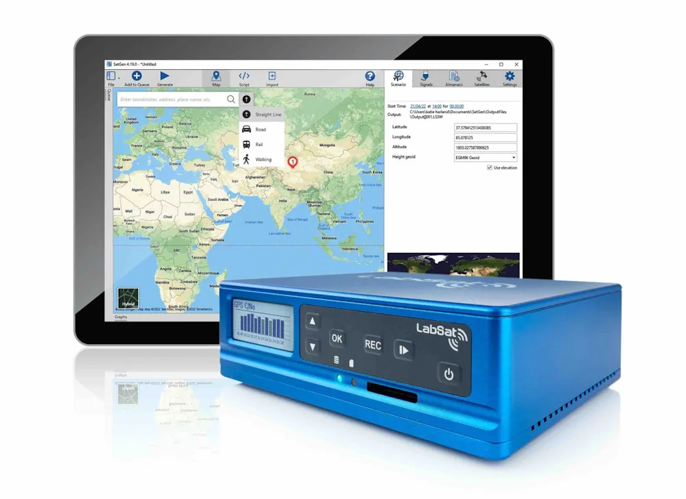
Geomaticians

UK

Scientists Analyze Record Storm Surges To Help Predict Future Flooding

Scientists Analyze Record Storm Surges To Help Predict Future Flooding

Researchers at the University of Southampton have conducted the most detailed spatial analysis to date of storm surges along the coast of the UK and Ireland. The oceanographers found that coastlines in the north of the Irish Sea experience the longest and largest surges, while those occurring around the southwest coast of England have the ...
eurekalert.org
LabSat Announces The Launch Of The LabSat 4 GNSS Simulator For Enhanced GNSS Testing

LabSat Announces The Launch Of The LabSat 4 GNSS Simulator For Enhanced GNSS Testing

LabSat has introduced the LabSat 4 GNSS Simulator, a GNSS test solution. This latest addition to the LabSat range is designed to meet the rigorous demands of modern GNSS signal testing, providing enhanced customization and precision. Key to LabSat 4 are its three RF channels, each configurable with up to 12-bit I&Q quantization and a ...
insidegnss.com
BAS Releases Interactive Antarctic Map Viewer

BAS Releases Interactive Antarctic Map Viewer

The British Antarctic Survey (BAS) has released a new map viewer that brings together all of the Antarctic Digital Database datasets, plus other useful information, and displays them together in an open-access interactive website. The BAS’ Mapping and Geographic Information Centre (MAGIC) is responsible for keeping the maps and data up to date, with the ...
spatialsource.com.au

New Smart Data Human Mobility Research Project

University of Liverpool researchers have been awarded funding from Smart Data Research UK (SDR UK) for a new project that aims to quantify and adjust existing biases in smart data on human mobility. Called DEBIAS, the project is led by Professor Francisco Rowe, who specialises in population data science with specific expertise in human mobility, ...
news.liverpool.ac.uk

Aston University Develops Lidar For Crop Monitoring

A project at the UK’s Aston University has received financial support for its work on enhancing lidar for crop monitoring applications. The award of a Royal Society Industry Fellowship grant worth £174,000 will be used to further develop a polarimetic lidar, funding work underway at the Aston Institute of Photonic Technologies (AIPT) in the lab ...
optics.org

UK Government Tests Quantum-Inertial Navigation Technology In Flight

The UK has successfully tested quantum-based navigation systems in flight. This commercial trial, led by the quantum technology firm Infleqtion, aims to enhance resilience against GPS jamming and spoofing. Although GPS jamming typically does not affect an aircraft’s flight path, Quantum-based Positioning, Navigation, and Timing (PNT) systems aim to provide accurate and resilient navigation, complementing ...
insidegnss.com
Hospital Using New Software To Manage Raac Repairs

Hospital Using New Software To Manage Raac Repairs

A West Yorkshire hospital has become the first in the UK to use new geospatial software to help pinpoint high-risk crumbling concrete panels. More than 80% of floors, walls and ceilings at the Airedale Hospital, in Keighley, are made of Raac, or reinforced autoclaved aerated concrete, which has a lifespan of about 30 years. Though ...
bbc.com
EarthSense And GISCAD To Take Air Monitoring Solutions To Portugal And Africa

EarthSense And GISCAD To Take Air Monitoring Solutions To Portugal And Africa

EarthSense, today announced a partnership with GISCAD, a Portugal-based geomatics and civil engineering solutions company, to bring its air quality monitoring solutions and services to Portugal, Angola and Mozambique. GISCAD provides a range of advanced technology equipment, software and technical support to its clients in the geomatics, engineering, construction and architecture sectors. Its partnership with ...
airqualitynews.com

Belfast To Spearhead UK’s Digital Revolution With £37m Digital Twin Centre

UK government has unveils a significant investment in its digital future with the announcement of a brand new £37.6 million National Digital Twin Centre to be established in Belfast. This state-of-the-art facility, led by the government-backed innovation agency Digital Catapult, promises to not only accelerate the adoption of digital twins but also bridge the gap ...
computing.co.uk
New Geological Map Reveals Secrets Of Greenland's Icy Interior

New Geological Map Reveals Secrets Of Greenland’s Icy Interior

A team of international scientists involving the Durham University Geography department has unveiled a new map of the geological provinces hidden beneath the Greenland Ice Sheet. This comprehensive synthesis, published in Geophysical Research Letters, promises to advance our understanding of this critical component of the global climate system. The new subglacial geology map provides an ...
phys.org
London Gatwick Airport Builds Geospatial Platform With Esri GIS

London Gatwick Airport Builds Geospatial Platform With Esri GIS

London Gatwick has created a new geospatial platform using Esri’s ArcGIS to support multiple operational areas at the airport, including engineering and environmental services. The system is already making engineering and construction works safer by reducing accidental strikes on buried utilities and enabling better management of the airports biodiversity. London Gatwick is one of the ...
gim-international.com

New PSGA Data Will Help Speed Up Emergency Response Times

A new selection of location datasets, including two new products, have been released today (Thursday 28 March) as part of the Public Sector Geospatial Agreement (PSGA). The new data and products have been delivered by Ordnance Survey (OS) and are set to support customers across a range of markets, including the emergency services, sustainability, land ...
gov.uk

Geospatial Commission-Funded Tool Demonstrates Potential For AI To Transform Decisions About Land Use

The Geospatial Commission, part of the Department for Science, Innovation and Technology (DSIT), has partnered with The Alan Turing Institute to explore the role that artificial intelligence (AI) can play in long-term decisions about how to use land. The UK is facing significant and competing pressures for its land. Advances in spatial data science and ...
gov.uk

Geospatial Commission Joins UK Centre For Seabed Mapping

The Geospatial Commission had today (Wednesday 20 March) become the 31st member of the UK Centre for Seabed Mapping (UK CSM). The UK CSM, which is administered by the UK Hydrographic Office (UKHO), was created in June 2022 to spearhead a coordinated approach to the collection, management and access of seabed mapping data and to ...
gov.uk
Biodiversity Survey Tool For Meeting New Net Gain Obligations

Biodiversity Survey Tool For Meeting New Net Gain Obligations

Esri UK partner Temple has created a biodiversity assessment tool, which could assist construction and engineering firms in meeting the biodiversity net gain (BNG) legislation that came into effect in England earlier this year. Environment, planning and sustainability consultancy Temple has joined geographic information system (GIS) software provider Esri UK’s partner network. This allows Temple ...
geplus.co.uk

AGI Launch Awards For Geospatial Excellence

The Association for Geographic Information (AGI) has re-launched its highly popular awards for excellence within the geospatial sector. Entries for the awards are being sought from organisations and individuals, working in or with geospatial, who want to showcase innovation, achievements and best practice. The AGI 2024 Awards Categories are the ‘Chairperson’s Award for Outstanding Service ...
directionsmag.com

Poor Spatial Navigation Could Predict Alzheimer’s Disease Years Before The Onset Of Symptoms

People at risk of Alzheimer’s disease have impaired spatial navigation prior to problems with other cognitive functions, including memory, finds a new study led by UCL researchers. The research, published in Alzheimer’s & Dementia, used virtual reality to test the spatial navigation of 100 asymptomatic midlife adults, aged 43-66, from the PREVENT-Dementia prospective cohort study. ...
medicalxpress.com

Geographic Information System To Assess And Mitigate Natural Disasters

Southampton University has partnered with three of Egypt’s top institutions in a project aiming to assess and mitigate natural disasters through geographic information system (GIS) mapping technology. The project, ‘Seismic Resilience of Egypt’s Built Environment: A GIS-Based Framework for Assessment and Mitigation’ (Egypt-SeReAM), has received £133.5K from the Engineering and Physical Sciences Research Council (EPSRC) ...
theengineer.co.uk
London Underground Is Testing Real-Rime AI Surveillance Tools To Spot Crime

London Underground Is Testing Real-Rime AI Surveillance Tools To Spot Crime

Thousands of people using the London Underground had their movements, behavior, and body language watched by AI surveillance software designed to see if they were committing crimes or were in unsafe situations, new documents obtained by WIRED reveal. The machine learning software was combined with live CCTV footage to detect aggressive behavior, guns or knives ...
wired.com
Cranfield Researches Radar Drones For Soil Moisture Monitoring

Cranfield Researches Radar Drones For Soil Moisture Monitoring

Experts at Cranfield University are leading a two-year project which combines Synthetic Aperture Radar with uncrewed aerial vehicles (UAV), evaluating how radar-equipped drones could simplify soil moisture measurements and revolutionise flood and drought management. The project, led by Dr Dan Evans, will assess the accuracy and potential applications of the innovative technology in soil moisture ...
adsadvance.co.uk

Register Now For GEO Business 2024

Visitor registration is now open for GEO Business, the UK’s largest geospatial event. The free-to-attend expo designed for geospatial professionals who want to unlock the power of location intelligence, returns to ExCeL London on 5-6 June 2024. The highly anticipated 2024 instalment is set to be the best yet, as it returns for its landmark ...
suasnews.com
UKHO And XOCEAN Team Up For Uncrewed Seabed Survey

UKHO And XOCEAN Team Up For Uncrewed Seabed Survey

Marine data provider XOCEAN recently deployed five uncrewed surface vessels (USVs) near the Isles of Scilly to collect bathymetric data on behalf of the UK Hydrographic Office (UKHO). The USVs scanned the seabed, identifying features such as depth, habitats, ridges, boulders and shipwrecks. This marked the UKHO’s inaugural use of an external organization for seabed ...
hydro-international.com

Geospatial Commission Highlights MUDDI Model For Subsurface Data

The Geospatial Commission has flagged up the development by the Open Geospatial Consortium (OGC) of a standard for data on subsurface features. It has been the first organisation to use the Model for Underground Data Definition and Integration (MUDDI) in its development of National Underground Asset Register (NUAR), which will provide a national data source ...
ukauthority.com
Many Women Bypass Nearest Hospital for Breast Cancer Surgery

Many Women Bypass Nearest Hospital for Breast Cancer Surgery

Many women undergoing breast-conserving surgery (BCS) or mastectomy bypass their nearest hospitals, according to a study published online Jan. 8 in Cancer. Ajay Aggarwal, M.D., Ph.D., from the London School of Hygiene and Tropical Medicine, and colleagues used linked administrative datasets from the English National Health Service to identify all women who underwent BCS or ...
healthday.com

A Mission To Add Guernsey To Google Street View

Aman who received a 360-degree camera as a gift has taken it upon himself to incorporate his neighbourhood in Guernsey into the Google Street View online map, according to a BBC report. According to Guernsey’s Office of the Data Protection Authority (ODPA), Google deployed cars on the island for the Street View service in 2010. ...
gim-international.com
English Peak District Harnesses AI For Aerial Landscape Mapping

English Peak District Harnesses AI For Aerial Landscape Mapping

The UK’s Peak District National Park Authority is pioneering the use of artificial intelligence (AI) to automate the production of highly detailed land cover maps, in a project in partnership with Cranfield University and The Alan Turing Institute. Land cover was classified from the Bluesky photography using Convolutional Neural Networks, a deep-learning AI method that ...
gim-international.com
To Understand How Animals Roam, Look At Human Movements, Study Says

To Understand How Animals Roam, Look At Human Movements, Study Says

To fully understand animal behavior and conservation, scientists are finding they need to study humans’ daily movements and activities. A paper published in Nature Ecology & Evolution brings together a multidisciplinary group of experts to examine how tracking human movements through landscapes over time can provide insights into wildlife behavior and conservation. This collaborative project ...
news.mongabay.com
GSA Created Buzz Around Google's Geospatial Software

GSA Created Buzz Around Google’s Geospatial Software

To inspire artists and creators to learn about and use Google’s new Geospatial Creator in Adobe Aero, Google Arts & Culture partnered with Global Street Art and three reknown artists to bring city streets in London, Mexico City and LA to life. The results picked up the AR/VR Award at The Drum Awards for Out ...
thedrum.com

IBM Advances Geospatial AI To Address Climate Challenges

IBM today announced new efforts that apply its geospatial AI technologies, including IBM’s geospatial foundation model developed in collaboration with NASA, to climate efforts including analysis of urban heat islands in the United Arab Emirates (UAE); reforestation across Kenya; and climate resiliency in the United Kingdom (UK). IBM continues to advance its AI model strategy ...
newsroom.ibm.com
AI Maps Icebergs 10,000 Times Faster Than Humans

AI Maps Icebergs 10,000 Times Faster Than Humans

In a groundbreaking development, researchers from the University of Leeds have unveiled a neural network that can swiftly and accurately chart the expanse of large Antarctic icebergs in satellite images, accomplishing the task in a mere 0.01 seconds. This novel approach is in stark contrast to the laborious and time-consuming manual efforts needed previously. Anne ...
esa.int