Geomaticians

Rwanda

Rwanda And UAE Sign MoU On Civil Space Activities

UAE and the Rwanda Space Agency have signed a memorandum of understanding with the UAE Space Agency to establish collaboration frameworks in civil space activities, fostering research and development, space technologies, geospatial data sharing, and initiating joint space sector projects. The agreement also offers opportunities for capacity building in space science and technology. This agreement ...
geospatialworld.net

RSA And Esri Sign MoU To Boost Geospatial Services For Rwanda’s Social-Economic Development

The CEO of the Rwanda Space Agency (RSA), Colonel Francis Ngabo, and the President of Esri, Jack Dangermond, signed a Memorandum of Understanding (MoU) to establish a collaborative partnership, setting the foundation for promoting geospatial services to drive social-economic development in Rwanda. The momentous event occurred on the sidelines of the 2023 Esri User Conference ...
africanews.space
Mapping Rwanda’s Trees From Above

Mapping Rwanda’s Trees From Above

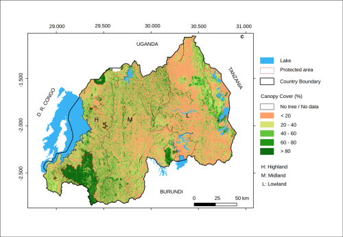
Aerial photos taken high above Rwanda are helping scientists monitor trees and determine how much carbon is locked in the verdant resource. The approach, detailed in a newly published study, revealed that most of the country’s trees lie outside its forests, although conservation and reforestation efforts need to address all ecosystems. Inside or outside forests, ...
eos.org

Au Rwanda, Un Nouvel Outil Cartographie La Teneur En CO2 Des Arbres

On connaît l’importance des écosystèmes forestiers pour séquestrer le carbone et lutter contre le dérèglement climatique. Mais la quantité de dioxyde de carbone que les arbres peuvent absorber reste difficile à évaluer de manière précise, ce qui entrave l’efficacité de mesures concrètes visant à limiter le réchauffement de la planète. Des chercheurs de l’université de ...
rtbf.be