Geomaticians

Russia

Computer Vision And Neural Networks To Help Detect Crop Diseases

Computer Vision And Neural Networks To Help Detect Crop Diseases

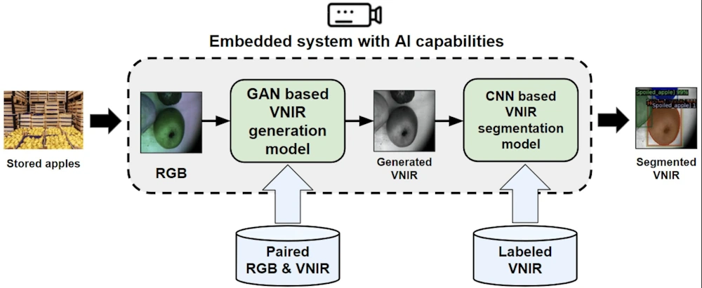
A research team from Skoltech and Saint-Petersburg State University of Aerospace Instrumentation have presented a paper in which they pioneered an alternative method for detecting decayed and moldy apples at the post-harvest stage, when fruits are stored and then delivered to the customer. A computer vision system will determine different defects at the early stage, ...
phys.org
Ecologists Use Satellite Images To Predict Wheat Yield With 98% Accuracy Via Satellite Imagery

Ecologists Use Satellite Images To Predict Wheat Yield With 98% Accuracy Via Satellite Imagery

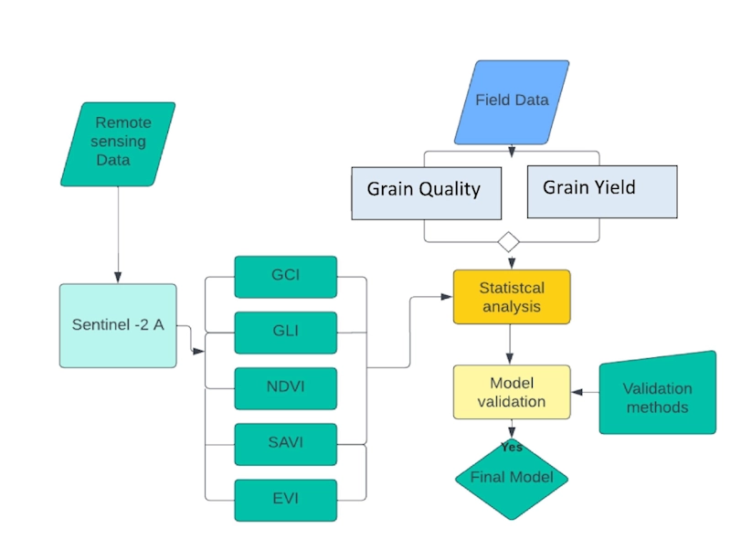
RUDN University ecologists found a parameter in satellite images that allows accurately calculating and increasing the wheat yield. Such technology helps agronomists monitor crops and make decisions. These results were published in The Egyptian Journal of Remote Sensing and Space Science. Low crop yields are usually associated with disturbances in agro-climatic conditions, improper or untimely ...
phys.org
В Анапе Разработают Мобильное Приложение Для Геологов

В Анапе Разработают Мобильное Приложение Для Геологов

Образовательная программа «Юная смена геологов» стартовала во Всероссийском детском центре «Смена». Проект объединил 150 школьников из 29 регионов России от 11 до 17 лет. В рамках программы сменовцы освоят базовые дисциплины и получат практические навыки по направлениям топография, ориентирование на местности, минералогия, кристаллография, петрография, палеонтология, основы горного дела, экология и геодезия. Образовательные занятия для проведут ...
anapa.media
Russia Launches Newly Redesigned Navigation Satellite

The first GLONASS-K2 satellite finally reached the launch status in the middle of 2023, or a decade behind the original schedule. At the end of July 2023, the adminstration of the Safronovskoe settlement in the Lensk District in the Arkhangelsk Region (Oblast) posted a letter from the Deputy Commander of the Russian Space Forces, VKS, ...
russianspaceweb.com

Russian Gov’t Agencies Banned From Using Foreign Geospatial Systems

Russian President Vladimir Putin signed a law prohibiting government agencies and a number of organizations from using foreign geospatial systems, technologies, and tools, local media reported on Saturday. According to RIA Novosti, the ban will apply to state corporations, public companies, and natural monopolies. The ban will also affect business entities in the authorized capital ...
english.news.cn

Получить Сведения Из Фонда Пространственных Данных Московской Области Теперь Можно Онлайн

Мособлархитектурой совместно с ГБУ МО «Мособлгеотрест» реализована новая онлайн-услуга «Предоставление пространственных данных и материалов, содержащихся в фонде пространственных данных Московской области», которая доступна на региональном портале госуслуг. В Фонд пространственных данных Московской области передаются данные и материалы, полученные в результате выполнения геодезических работ, ортофотопланы и результаты аэро- и космических съемок. На сегодня Фонд содержит порядка ...
inpushkino.ru

Russia May Build Satellite Data Receiving Station In South Africa

According to a report by Sputnik, Yuri Borisov, the Director-General of the Russian State Space Corporation, proposed that the South African Space Agency (SANSA) consider the deployment of a Russian data-receiving station on a South African territory that would receive information from Russian and foreign Earth observation satellites, during the BRICS meeting in South Africa ...
africanews.space
Для Екатеринбурга Создали Реалистичную 3D Модель Парка

Для Екатеринбурга Создали Реалистичную 3D Модель Парка

Компания «2ГИС» приступила к внедрению новых визуальных элементов в свои карты. Теперь на геосервисе будут появляться реалистичные 3D модели знаковых городских зданий, а также скверов и парков. Например, первой обновленной локацией в Екатеринбурге стала площадь Кирова, где высадили 3D деревья. — Иммерсивные карты открывают новые возможности для визуализации городов в геосервисе. Это меняет восприятие карт ...
momenty.org

China Shares 1.5 TB Of Satellite Imagery Data With BRICS

Since the signing of an agreement on Cooperation on BRICS Remote Sensing Satellite Constellation in August 2021, China has shared 400 scenes of satellite imagery data with BRICS countries, with the total volume amounting to 1.5 TB. Zhang Kejian, head of the China National Space Administration, made the remarks Friday in virtual format at the ...
english.news.cn

Venezuela Contará Con Nueva Estación Para Sistema De Navegación Global Por Satélite En 2023

Representantes de la Agencia Bolivariana de Actividades Espaciales (ABAE) y de la corporación espacial rusa Roscosmos firmaron un convenio para la instalación de una nueva estación de medición para el Sistema de Navegación Global por Satélite (Glonass por sus siglas en ruso) en la Base Aeroespacial Capitán Manuel Ríos, ubicada en la población El Sombrero, ...
correodelorinoco.gob.ve

Russia Provides Space Imagery Of The Earth’s Territories To The BRICS Countries

The data were provided within the framework of the agreement signed in 2021 between the BRICS countries on exchanging such information to tackle climate change, help protect the environment and mitigate the consequences of natural and man-made emergencies and disasters. “From June to October 2022, under a contract with Roscosmos, a space survey of foreign ...
tvbrics.com

GPS Signals Are Being Disrupted In Russian Cities

New data analysis reveals that multiple major Russian cities appear to have faced widespread GPS disruption during the past week. The signal interference follows Ukraine launching long-range drone attacks deep into Russian territory, and it may act as a way to potentially stop drones that rely upon GPS for navigation, experts say. The GPS interference ...
wired.com

Iran, Russia Sign Deal To Develop Space Cooperation

The agreement was signed by the head of Iran’s Space Agency Hassan Salarieh and the chief of Russia’s space agency, Roscosmos Yury Borisov on the sidelines of an International Aerospace Exhibition in Kish Island in southern Iran in the Persian Gulf. This cooperation document includes a variety of topics, including cooperation in the construction of ...
en.mehrnews.com
Soyuz-2.1b Launches Final GLONASS-M Satellite From Plesetsk

Soyuz-2.1b Launches Final GLONASS-M Satellite From Plesetsk

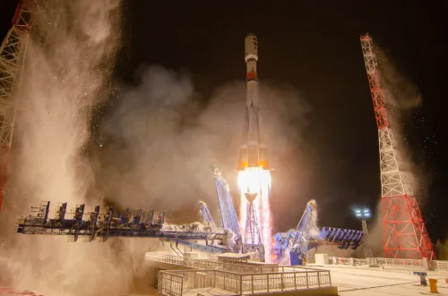
At 15:17 UTC on Nov. 28, a Soyuz-2.1b launched from Site 43/3 at the Plesetsk Cosmodrome, carrying the final GLONASS-M satellite to orbit, designated Kosmos-2564. This is the first of two planned launches from the Plesetsk Cosmodrome in just three days, with a classified payload scheduled to launch onboard a Soyuz-2.1a on Wednesday, Nov. 30. ...
nasaspaceflight.com

Russia Successfully Launches Navigation Satellite – Interfax

Russia launched its Soyuz-2.1b rocket carrying the GLONASS-K navigation system on Monday from a northern cosmodrome, the Interfax news agency reported, citing the defence ministry. “Combat crews of the Space Forces …. successfully launched a Soyuz-2.1b medium-class launch vehicle with space navigation GLONASS-K system,” the agency cited the ministry as saying. The GLONASS-K satellite lifted ...
euronews.com

No Hay Acuerdo Con Moscú Para Instalar Aquí Sistema De GPS Satelital: SRE

La Secretaría de Relaciones Exteriores (SRE) aclaró ayer que el acuerdo firmado entre México y la Federación Rusa en materia espacial “no contempla acciones relacionadas con el sistema Glonass ni existe previsión de que pudiera ser incluido en un futuro cercano”, y precisó que no ha sido ratificado ni por el Senado ni por el ...
jornada.com.mx
Galileo’s Next Ride Moving Towards Operational Status

Galileo’s Next Ride Moving Towards Operational Status

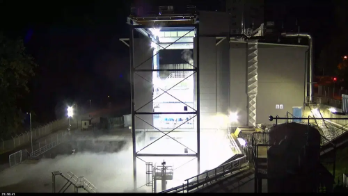
ESA’s Ariane 6 launch vehicle, on which the deployment of the EU’s Galileo GNSS satellite constellation now depends, has taken another step towards first flight. A fresh series of hot fire tests of the rocket’s upper stage and all-new Vinci engine is now underway at Germany’s DLR center for engine and stage testing in Lampoldshausen. ...
insidegnss.com

Russia To Launch Iran Remote Sensing Satellite Into Orbit On Tuesday

“In cooperation with Russia, the Khayyam satellite will be launched next week from the Baikonur space station in Kazakhstan by a Soyuz satellite carrier,” the Iranian space agency said late on Wednesday. The satellite, apparently named after 11th-12th century Persian polymath Omar Khayyam, aims to “monitor the country’s borders”, enhance agricultural productivity and monitor water ...
english.alaraby.co.uk

Roscosmos Lanza El Satélite Glonass-k Desde Plesetsk

Las fuerzas espaciales rusas lanzaron el pasado día 7 de julio un cohete Soyuz-2.1b con el satélite Glonass-K. Dos minutos después del lanzamiento, el cohete fue monitorizado por el complejo de control automatizado basado en tierra del Centro Espacial Principal de Pruebas que lleva el nombre de German Titov. El satélite puesto en órbita repondrá ...
actualidadaeroespacial.com