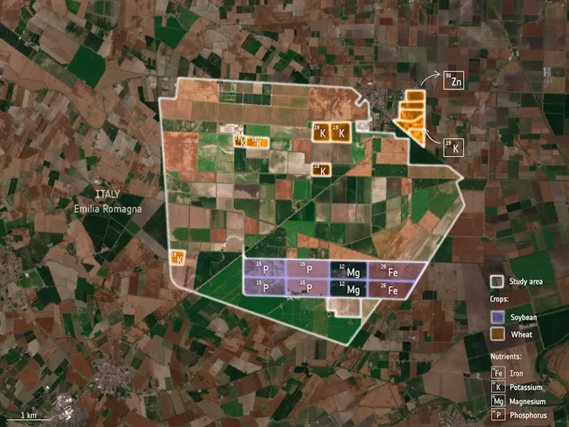
Geomaticians

Netherlands

Scientists Analyze Record Storm Surges To Help Predict Future Flooding

Scientists Analyze Record Storm Surges To Help Predict Future Flooding

Researchers at the University of Southampton have conducted the most detailed spatial analysis to date of storm surges along the coast of the UK and Ireland. The oceanographers found that coastlines in the north of the Irish Sea experience the longest and largest surges, while those occurring around the southwest coast of England have the ...
eurekalert.org
Study Reviews Current State Of Global Navigation Satellite System Reflectometry

Study Reviews Current State Of Global Navigation Satellite System Reflectometry

Global navigation satellite system reflectometry (GNSS-R) is emerging as a pivotal technology in remote sensing due to its ability to provide high-precision, real-time data under all weather conditions. Traditionally, the GNSS has been utilized for positioning, navigation, and timing. However, recent advancements have demonstrated its efficacy in environmental monitoring through scatterometry and reflectometry. GNSS-R capitalizes ...
phys.org
AI And Drones Aid Farmers With Identifying Botrytis

AI And Drones Aid Farmers With Identifying Botrytis

Researchers from Unmanned Valley, Greenport DB, and NL Space Campus in the Netherlands have successfully developed an AI model that enables drones to identify the disease botrytis. The model leverages artificial intelligence to analyze vast amounts of drone data, resulting in a detailed map that pinpoints, with millimeter precision, which plants are diseased or at ...
futurefarming.com
Mapping How Deforested Land In Africa Is Used

Mapping How Deforested Land In Africa Is Used

Africa’s forested areas—an estimated 14 % of the global forest area—are continuing to decline at an increasing rate—mostly because of human activities to convert forest land for economic purposes. As natural forests are important CO2 and biodiversity reservoirs, this development has a significant impact on climate change and affects the integrity of nature. To intervene ...
phys.org

Cyfrowy Bliźniak Pomoże Ograniczyć Emisję Dwutlenku Węgla

Naukowcy z Instytutu Geodezji i Geoinformatyki UPWr pracują nad projektem DigiTwins4PEDs, który do modelowania aspektów energetycznych miast wykorzysta cyfrowego bliźniaka miasta. To krok w kierunku miast neutralnych pod względem emisji dwutlenku węgla i zrównoważonej przyszłości energetycznej. Badania finansuje Narodowe Centrum Nauki. Project „Utilisation of urban digital twins to co-create flexible positive energy systems for districts” ...
tuolawa.pl
An Open-Source Tool To Assist In Multi-Hazard Risk Assessment

An Open-Source Tool To Assist In Multi-Hazard Risk Assessment

RiskChanges is an open-source cloud-based spatial decision support tool using a dynamic and comprehensive approach to multi-hazard risk assessment. It is designed to support orgaizations in assessing and managing risks associated with multiple hazards at the local level to select optimal risk reduction alternatives. RiskChanges was developed by the University of Twente in collaboration with ...
reliefweb.int
Measuring Nutrition In Crops From Space

Measuring Nutrition In Crops From Space

With many people around the world suffering from various forms of malnutrition it’s important that the absolute basics such as rice, soya and wheat are as nourishing as possible. ESA-funded research shows that the Copernicus Sentinel-2 mission and the Italian Prisma mission could be used to monitor the nutritional content of staple crops. This could, ...
esa.int
Using AI To Push The Boundaries Of Wildlife Survey Technologies

Using AI To Push The Boundaries Of Wildlife Survey Technologies

In their research, associate professor from the NRS Department Tiejun Wang and his master’s student Zijing Wu developed an AI-model to automatically locate and count large herds of migratory ungulates (wildebeest and zebra). They used their method in the Serengeti-Mara ecosystem using fine-resolution (38–50 cm) satellite imagery. They achieved accurate detection of nearly 500,000 individuals across ...
phys.org
Geospatial World Forum 2023 To Be Held In Rotterdam In May

Geospatial World Forum 2023 To Be Held In Rotterdam In May

The Geospatial World Forum (GWF) is gearing up for its 14th edition, and it promises to be a must-attend event for professionals in the geospatial industry. With expected participation of 800+ attendees from more than 75 countries, the GWF is set to be a global gathering of industry leaders, innovators, and experts. More than 300 ...
geospatialworld.net
National Geographic Society And Utrecht University Launch World Water Map

National Geographic Society And Utrecht University Launch World Water Map

The National Geographic Society launched the World Water Map as part of its five-year World Freshwater Initiative to better understand developing freshwater shortages around the world and inspire sustainable action. The Map was created by the National Geographic Society in cooperation with Utrecht University and Esri to identify water availability hotspots, visualize global freshwater supply ...
blog.nationalgeographic.org

HERE, AWS Provide Device Positioning Services To Developers

HERE Technologies, a location data platform, announced its collaboration with Amazon Web Services (AWS), a cloud platform. This collaboration will deliver improved performance for indoor and outdoor positioning capabilities, enabling AWS third-party developers to track and manage internet-of-things (IoT) devices. HERE Positioning enables developers to switch between different localizing technologies, and it relies exclusively on ...
geospatialworld.net

Geospatial World Forum Returns To Rotterdam With Industry-advancing Agenda

This year marks the 14th edition of Geospatial World Forum (GWF), a platform for global geospatial community, attended by senior executives representing public policies, national geospatial and space agencies, large business enterprise users, commercial companies, and professional and academic institutions from 75+ countries. After three consecutive years in Amsterdam, the event returns to Rotterdam, to ...
geospatialworld.net

HERE Introduces UniMap To Revolutionize How Maps Are Created, Updated And Used

Digital maps just took a huge leap forward. At CES 2023, HERE Technologies, the world’s leading location platform, unveiled UniMap, a revolutionary, highly automated mapping technology that enables rapid creation of digital maps and location products. HERE has been developing the technology over the last three years in close collaboration with automotive groups including BMW ...
directionsmag.com

Meta, Microsoft, AWS And TomTom Launch The Overture Maps Foundation To Develop Interoperable Open Map Data

The Linux Foundation has partnered with some of the world’s biggest technology companies to develop interoperable and open map data, in what is a clear move to counter Google’s dominance in the mapping realm. The Overture Maps Foundation, as the new effort is called, is officially hosted by the Linux Foundation, but the program is ...
techcrunch.com
Predicting The Future Landscape Of A River

Predicting The Future Landscape Of A River

A joint research team, including scientists from Korea Institute of Civil Engineering and Building Technology (KICT) and Deltares of the Netherlands, has conducted research on prediction of the future changes in river landscapes using an eco-morphodynamic model applied to an actual river. According to the study result, the vegetation cover will increase continuously until 2031, ...
phys.org
Point Clouds Come Alive In New Book By Mathias Lemmens

Point Clouds Come Alive In New Book By Mathias Lemmens

‘Introduction to Pointcloudmetry’ is the title of the new book by Mathias Lemmens, former editor-in-chief of GIM International. Despite the in-depth text, it is a clearly and accessibly presented book treating the major concepts of point clouds generated by laser scanning as well as overlapping photogrammetric images. In the publication, Lemmens discusses various aspects that ...
gim-international.com
A Navigation System With 10 Centimeter Accuracy

A Navigation System With 10 Centimeter Accuracy

Researchers of Delft University of Technology, Vrije Universiteit Amsterdam and VSL have developed an alternative positioning system that is more robust and accurate than GPS, especially in urban settings. The working prototype that demonstrated this new mobile network infrastructure achieved an accuracy of 10 centimeter. This new technology is important for the implementation of a ...
eurekalert.org
Study Brings Satellite Data Down To Earth For Biomass Tracking

Study Brings Satellite Data Down To Earth For Biomass Tracking

Each data-gathering method has advantages and limitations. National forest inventories (NFIs), which include biomass estimates and are conducted in most of the world’s countries, are based on field plots. But monitoring those field plots is costly, so the number is limited, and results must be averaged out over the country, resulting in less-precise calculations. Satellites ...
forestsnews.cifor.org