Geomaticians

Japan

EarthCARE Launched To Study Role Of Clouds And Aerosols In Earth's Climate

EarthCARE Launched To Study Role Of Clouds And Aerosols In Earth’s Climate

ESA’s EarthCARE satellite, poised to revolutionise our understanding of how clouds and aerosols affect our climate, has been launched. This extraordinary satellite embarked on its journey into space on 29 May at 00:20 CEST (28 May, 15:20 local time) aboard a Falcon 9 rocket from the Vandenberg Space Force Base in California, US. Just 10 ...
esa.int

In A First, Japan Doctors Sue Google Over Negative Reviews On Firm’s Map App

A group of 63 doctors filed a lawsuit with the Tokyo District Court on Thursday against Google seeking ¥1.45 million (about $9,400) in compensation for causing harm to their businesses through what they described as one-sided, hateful reviews for their clinics on Google Maps. The suit is the first in Japan — and possibly the ...
japantimes.co.jp

The Integrated Transport Centre Signs A MoU With A Leading Japanese Company “Location Mind” In Research And Development

On the sidelines of the 10th session of the Abu Dhabi Japan Economic Council, held in the capital Abu Dhabi, the Integrated Transport Centre (ITC) of the Department of Municipalities and Transport (DMT) in Abu Dhabi signed a strategic Memorandum of Understanding (MoU) with “Location Mind”, a leading Japanese company in the field of research, ...
zawya.com

S. Korea, Japan To Cooperate In Developing Satellite Navigation System

South Korea and Japan will collaborate on the development and operation of regional satellite navigation systems in East Asia, Seoul’s science ministry said Tuesday. The two countries signed a memorandum of cooperation (MOC), designed for practical cooperation in developing and operating their respective satellite systems in the region, according to the Ministry of Science and ...
en.yna.co.kr
Synspective + Dynamic Map Platform Selected For Enterprise Innovation Promotion Program

Synspective + Dynamic Map Platform Selected For Enterprise Innovation Promotion Program

Synspective Inc. (Synspective) and Dynamic Map Platform Co., Ltd. (Dynamic Map Platform) have been selected by the Japanese Ministry of Land, Infrastructure, Transport and Tourism for the Small and Medium Enterprise Innovation Promotion Program. This project leverages SAR satellite technologies and Synspective’s Land Displacement Monitoring (LDM) solution and aims to integrate these technologies with HD ...
news.satnews.com
ESA’s Cloud Mission In The Limelight

ESA’s Cloud Mission In The Limelight

Dedicated to delivering a wealth of new information on exactly how clouds and aerosols affect Earth’s climate, ESA’s EarthCARE satellite has had the chance to show off prior to engineers embarking upon the careful task of packing it up for its journey to the launch site in the US. Carrying four different instruments, this remarkable ...
esa.int
Satellite Remote Sensing Model For Wide-Area Prediction Of Transpiration Rates In Japanese Cypress Plantations

Satellite Remote Sensing Model For Wide-Area Prediction Of Transpiration Rates In Japanese Cypress Plantations

Forests, known as nature’s “green dams,” play a crucial role in replenishing Earth’s groundwater reserves. However, overcrowding in planted forests due to lack of maintenance activities, such as thinning practices, is a pressing concern in Japan. This overcrowding causes substantial water loss from these forests into the atmosphere through a combination of soil evaporation and ...
phys.org
Researchers Pioneer New Surveying Method Using UAVs And Laser Scanners

Researchers Pioneer New Surveying Method Using UAVs And Laser Scanners

A Japanese research team recently published a paper outlining an innovative approach to surveying using Unmanned Aerial Vehicles (UAVs), commonly known as drones. The drones collect topographic and architectural data, which are used to create 3D computer-generated images. The researchers aim to enhance the method’s accuracy by fine-tuning the coordination of hardware and data. This ...
japan-forward.com
Images Of Simulated Cities Help Artificial Intelligence To Understand Real Streetscapes

Images Of Simulated Cities Help Artificial Intelligence To Understand Real Streetscapes

Recent advances in artificial intelligence and deep learning have revolutionized many industries, and might soon help recreate your neighborhood as well. Given images of a landscape, the analysis of deep-learning models can help urban landscapers visualize plans for redevelopment, thereby improving scenery or preventing costly mistakes. To accomplish this, however, models must be able to ...
techxplore.com
Japanese SAR Company IQPS To Launch With Rocket Lab After Virgin Orbit Bankruptcy

Japanese SAR Company IQPS To Launch With Rocket Lab After Virgin Orbit Bankruptcy

A Japanese company developing a constellation of synthetic aperture radar (SAR) imaging satellites is the latest to turn to Rocket Lab after the bankruptcy of rival launch company Virgin Orbit. Rocket Lab announced Aug. 17 that it signed a contract with Institute for Q-shu Pioneers of Space (iQPS) for a dedicated launch of its QPS-SAR-5 ...
spacenews.com
Indonesia, Japan Explore Cooperation To Develop Satellite Navigation

Indonesia, Japan Explore Cooperation To Develop Satellite Navigation

Indonesia’s National Research and Innovation Agency (BRIN) and Japan’s National Space Policy Secretariat of the Cabinet Office have signed a letter of intent (LOI) for cooperation to develop and utilize satellite navigation systems and technologies. Regarding the LOI for cooperation with Japan, BRIN’s Head of Research Organization for Electronics and Informatics Budi Prawara said Japan’s ...
en.antaranews.com
Paraguay Y Japón Fortalecen Cooperación En Programa Espacial Para El Desarrollo

Paraguay Y Japón Fortalecen Cooperación En Programa Espacial Para El Desarrollo

Paraguay y Japón suscribieron este lunes un acuerdo para la gestión de un programa espacial aplicado al desarrollo socioeconómico, que incluirá asistencia y equipamiento para el Laboratorio de Sistemas de Información Geográfica y Observación de la Tierra (GEOLab). El acuerdo fue suscripto con motivo de la visita oficial del director del presidente de la Agencia ...
ip.gov.py
Underground Navigation May Be Possible With Cosmic-ray Muons, Research Shows

Underground Navigation May Be Possible With Cosmic-ray Muons, Research Shows

Superfast, subatomic-sized particles called muons have been used to wirelessly navigate underground for the first time. By using muon-detecting ground stations synchronized with an underground muon-detecting receiver, researchers at the University of Tokyo were able to calculate the receiver’s position in the basement of a six-story building. As GPS cannot penetrate rock or water, this ...
techxplore.com
Social Media Snaps Map The Sweep Of Japan’s Cherry Blossom Season In Unprecedented Detail

Social Media Snaps Map The Sweep Of Japan’s Cherry Blossom Season In Unprecedented Detail

Social media contains enormous amounts of data about people, our everyday lives, and our interactions with our surroundings. As a byproduct, it also contains a vast trove of information about the natural world. In a new study published in Flora, we show how social media can be used for “incidental citizen science”. From photos posted ...
theconversation.com
Mapping The Conflict Between Farming And Biodiversity

Mapping The Conflict Between Farming And Biodiversity

Food is one of society’s great moral quandaries. Its production pushes many species to the brink of extinction and the grazing of land that destroys ecosystems. For governments, industry, and communities to effectively balance agricultural needs with environmental needs, however, quantitative information is required. Researchers in Japan, including the Research Institute for Humanity and Nature ...
eurekalert.org
Google And Taito Reveal Augmented Reality 'Space Invaders' Game

Google And Taito Reveal Augmented Reality ‘Space Invaders’ Game

Google and Japanese games company Taito are teaming up for a new augmented reality version of the 1978 shoot ‘em-up arcade game Space Invaders. Inspired by the original gameplay, players are tasked with defending the Earth from Space Invaders in their neighborhood. Powered by Google’s ARCore Geospatial API and Streetscape Geometry API, the upcoming SPACE ...
hypebeast.com

Synspective And Thaicom Partner On Disaster Response In Southeast Asia

Imagery startup Synspective and regional operator Thaicom are partnering to jointly offer synthetic aperture radar (SAR) for disaster response in Thailand. The two companies announced Tuesday they plan to offer a solution to government, defense, agriculture, and finance sectors in Thailand, with Synspective’s SAR technology and Thaicom’s knowledge of the satellite and space sector in ...
satellitetoday.com

Tenchijin Collaborates With Toyota City To Determine Potential Leakage Zones Using Satellite Data: A Project Authorized From Japan Cabinet Office

JAXA accredited space venture Tenchijin collaborates with Toyota City Water Supply and Sewerage Bureau and Fuji Chichu Joho, Inc to determine potential leakage zones using space satellite Big Data. This pilot project started in February 2022. In July 2022, this project was selected as the “Advances Satellite Remote Sensing Data Application Model Demonstration Project for ...
businesswire.com
Japan Has More Than 14,000 Islands, Digital Mapping Reveals

Japan Has More Than 14,000 Islands, Digital Mapping Reveals

Thanks to digital mapping technology, Japanese geographers have identified more than 7,000 islands previously unrecognized in the country’s waters. The first such survey in 35 years revealed that the nation is made up of 14,125 islands rather than 6,852, as previously thought, according to a source familiar with the matter. The Geospatial Information Authority of ...
asahi.com

Synspective And Insight Terra Announce Space-enabled Data And Monitoring Solution For Mine Tailings Facilities

Synspective, a Tokyo based SAR (synthetic aperture radar) satellite data and solutions provider, and Insight Terra, a London based start-up providing a cloud based environmental and infrastructure risk management platform and solutions, have entered into a strategic partnership to deliver a new space enabled data and monitoring solution for the mining industry. The solution uses ...
realwire.com

Northstar Signe Un Partenariat Avec Une Entreprise Japonaise

L’entreprise montréalaise NorthStar Ciel & Terre, a annoncé mercredi avoir signé une entente avec l’entreprise japonaise Axelspace, dans le but de fournir les tout premiers services de suivi d’objets spatiaux (SSA) combinés sol/espace. Les services de surveillance par satellites proposés par NorthStar permettent notamment à ces clients d’éviter les collisions dans l’espace. «Le développement durable ...
journaldequebec.com

Hexagon And OSASI Technos Partner To Develop Disaster Management And Prediction Solutions

Hexagon’s Safety, Infrastructure & Geospatial division and OSASI Technos Inc. have announced a partnership to deliver next-generation disaster management and monitoring solutions. Using 3D visualization capabilities, governments will be able detect, predict and simulate impending disasters, enabling them to better plan for and respond to impending disasters, enabling them to better plan for and respond ...
geospatialworld.net
Japan Launches Project To Map 90% Of Coastal Waters

Japan Launches Project To Map 90% Of Coastal Waters

The ‘Umi-no-Chizu’ (‘Map of the Sea’) project will use aerial measurement to map 90% of Japan’s shallow coastal waters (to a depth of 20m). This is a joint project by the Japan Hydrographic Association (JHA) and The Nippon Foundation. Regulatory, administrative management and jurisdiction issues have meant that less than roughly 2% of Japan’s coastal ...
gim-international.com

Japan Space Imaging Corporation Signs Deal With Satellite Vu

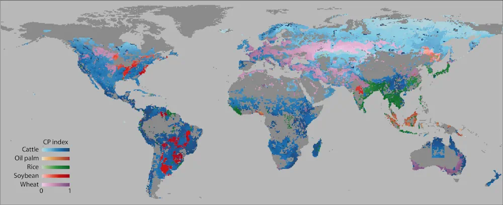
British satellite operator Satellite Vu, has signed a multimillion pound purchase option with Japanese satellite remote sensing commercial services provider Japan Space Imaging Corporation (JSI), following the opening of Satellite Vu’s Early Access Option Programme (EAOP), the company said. Trough the EAOP customers and partners gain access to Satellite Vu’s imagery, products, and services. They ...
spacewatch.global

Synspective’s Third SAR Satellite “Strix-1” Successfully Reaches Target Orbit

Synspective Inc., a SAR satellite data and solutions provider, announced today that StriX-1, its third SAR satellite, has successfully been put into its target orbit. On September 16 (JST), StriX-1 was deployed by Rocket Lab’s Electron at Rocket Lab Launch Complex 1 on New Zealand’s Mahia Peninsula. The satellite was put into its target orbit: ...
geospatialworld.net
Argentina Y Japón Desarrollan Sistema De Alerta De Inundaciones Urbanas Repentinas

Argentina Y Japón Desarrollan Sistema De Alerta De Inundaciones Urbanas Repentinas

La directora del Servicio Meteorológico Nacional, Celeste Saulo, encabezó el evento en el Edificio Libertador con la presencia del Embajador de Japón en Argentina, Takahiro Nakamae. El Proyecto Pronóstico y Alerta de Eventos de Inundaciones Repentinas (PREVENIR) es una una iniciativa de investigación conjunta la Agencia de Cooperación Internacional del Japón (JICA), la Agencia de ...
andigital.com.ar