Geomaticians

India

Mumbai Activists Demand That The Tree Geo-tagging Information Be Made Public

Mumbai Activists Demand That The Tree Geo-tagging Information Be Made Public

Activists demand the information be made public to bring transparency to the process and increase citizen participation in tree conservation. In 2018, activist Gopal Jhaveri in Mumbai, discovered that four coconut trees in his area, Borivali, had been poisoned by miscreants to achieve a clear view for an advertisement hoarding. Jhaveri lodged a police complaint ...
india.mongabay.com

The Second United Nations World Geospatial Information Congress Commences In Hyderabad

The Second United Nations World Geospatial Information Congress (UNWGIC 2022) officially started on 11 October 2022, Tuesday in Hyderabad, India. Convened by the United Nations Committee of Experts on Global Geospatial Information Management (UN-GGIM), the Second UNWGIC 2022 is organized by the Department of Economic and Social Affairs of the United Nations and hosted by ...
geospatialworld.net
Students Showcase Their Spatial Thinking In Localizing Sdgs At The 2nd UN-WGIC

Students Showcase Their Spatial Thinking In Localizing Sdgs At The 2nd UN-WGIC

Students From 18 Schools Across The Country Presented New Ideas On How Geospatial Technologies Can Be Embedded To Address Local Challenges Like Protecting The Heritage, Soil Fertility, Crop Diversity, Clean City, Water Management, Women Empowerment, Waste Management, Digital India, Clean Energy, Climate Change And So On To Achieve Sustainable Development Goals (Sdgs). Teams From 18 ...
geospatialworld.net

India’s Space Launch Segment To Propel To $13 Bn By 2025: Report

With the rapidly growing space ecosystem, the space launch segment in India is likely to grow to $13 billion by 2025, growing at a CAGR of 6 percent, a report showed on Monday. The space launch segment in the country is spurred by growing private participation, latest technology adoption and the low-cost of launch services, ...
siasat.com
Apple And Other Companies Concerned As India Tries To Push Its Own GPS System

Apple And Other Companies Concerned As India Tries To Push Its Own GPS System

As reported by Reuters (via Tecnoblog), the Indian government wants to reduce its dependence on foreign systems like GPS (which is owned by the US) by creating its own technologies. One of these technologies is NavIC (Navigation with Indian Constellation), which works pretty much the same way as GPS but is focused on providing “more ...
9to5mac.com

Varsity Prepares GIS-based Soil Map Of Ahmedabad City

CEPT university has prepared a Global Positioning System and Geographical Information System (GIS)-based soil map of Ahmedabad city in hopes of paving a solution for repeated cave-ins and flooding in Ahmedabad city. The map was prepared by the university’s Faculty of Technology last year, using geospatial technology. Information was collected from 563 points across the ...
indianexpress.com

India Sharpens Focus On Geospatial Technology Application In Agriculture

The Government of India has been emphasising on the use of technology for the benefit of the agriculture sector and farmers. The government has taken several initiatives towards promoting digital agriculture. Agriculture Ministry set up a specialised organisation Mahalanobis National Crop Forecast Centre (MNCFC) in 2012 as an attached office of the Department of Agriculture ...
agriculturepost.com
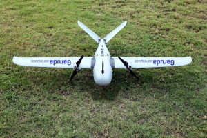
Garuda Aerospace sets record by mapping 7,000 villages in U.P. using drones

Garuda Aerospace sets record by mapping 7,000 villages in U.P. using drones

The Chennai-based drone start up Garuda Aerospace has successfully mapped 7,000 villages in Uttar Pradesh under the Svamitva Scheme. It had won the tender from the nodal agency, the Survey of India in September 2021. As per the tender, it was authorised to deploy drones for large-scale mapping and digitisation of land records in rural ...
thehindubusinessline.com

Leading Space Innovators Join Forces To Create World’s First Satellite With Both SAR And Optical Payloads To Revolutionize Geospatial Imaging

Antaris, the software platform provider for space, and GalaxEye, an imaging satellite operator, today announced the signing of a Memorandum of Understanding to create the world’s first satellite featuring both SAR and optical sensors on a single satellite. The MOU highlights a unique commitment between three Indian space leaders—GalaxEye, Ananth Technologies and XDLINX Labs—and US-based ...
spaceref.com

MoU Signed Between Disaster Management Authorities Of India, Maldives

The Union Cabinet, chaired by Prime Minister Narendra Modi has ex-post facto approved the Memorandum of Understanding (MoU) signed on August 2, 2022 between the National Disaster Management Authority of the Republic of India and the National Disaster Management Authority of the Republic of Maldives on cooperation in the field of Disaster Management, a press ...
theprint.in

RMSI Cropalytics Launches India’s First Ever Village-level Crop Map

The RMSI Cropalytics Crop Map aims to provide the geo-location of standing crops. They allow acreage aggregation at any level – village, gram panchayat, taluka or district. Since the acreages are plotted on the map and measured for the area, they are more accurate and actionable at higher resolutions. The crop map will be updated ...
indianexpress.com
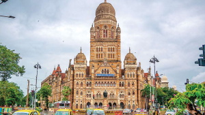
BMC Developing 3D Digital Map Of Mumbai City

BMC Developing 3D Digital Map Of Mumbai City

After attempting the project as a pilot in South Mumbai’s Worli neighbourhood in September of last year, the Brihanmumbai Municipal Corporation (BMC) has begun the process of developing a three-dimensional digital model of Mumbai city. In addition to its open spaces, municipal facilities, and slums, Mumbai’s buildings, roads, bridges, underpasses, water bodies, means of transportation, ...
scoopearth.com

Google Launches Street View In 10 Indian Cities

Google Launches Street View In 10 Indian Cities

Google announced the launch of its Street View experience in India in partnership with Genesys International, an advanced mapping solutions company, and Tech Mahindra, a leading provider of digital transformation, consulting, and business re-engineering services and solutions. Starting today, Street View will be available on Google Maps with fresh imagery licensed from local partners covering ...
geospatialworld.net
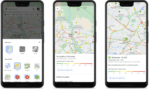
Indian Cities Partner With Google To Improve Road Safety, Cut Emissions

Indian Cities Partner With Google To Improve Road Safety, Cut Emissions

Navigating peak rush hour traffic has become a familiar fixture of city life, leading to interminable gridlocks, frustrating congestions and severe pollution, along with crucial hours lost daily. The problem is quite acute in Bengaluru, where, as per a 2019 TomTom report, residents lose over 243 hours every year due to traffic. In order to ...
geospatialworld.net
Nagaland To Utilise Satellite Tech To Monitor Projects In Remote Areas

Nagaland To Utilise Satellite Tech To Monitor Projects In Remote Areas

The Nagaland government will utilise satellite technology in proper monitoring of projects in remote areas which are otherwise difficult to reach, due to the rough terrain of the state, officials said on Tuesday. Principal Secretary and Development Commissioner, Amardeep Singh Bhatia, addressing at a day-long workshop for nodal officers of line departments on the implementation ...
daijiworld.com

UIDAI-ISRO Portal To Locate Your Nearest Aadhaar Centre In Few Clicks

Today, a 12-digit unique number is facilitating mobility for millions of people who migrate from one part of the country to another, as it is a universal identity across India. The National Remote Sensing Centre (NRSC), one of the core centres of the Indian Agency – ISRO, have collaborated with the Unique Identification Authority of ...
newsonair.com

Mumbai: GIS Mapping Of All MHADA Land

The Maharashtra Housing and Area Development Authority (MHADA) is developing an advanced computerised system for all its land banks using geographical information system (GIS) mapping and robotic process automation (RPA), its public relations office (PRO) said in a media statement issued on Friday.
freepressjournal.in

India’s Largest Drone Manufacturing Facility Inaugurated In Roorkee

In line with Prime Minister Modi’s vision to turn India into a global drone hub by 2030, Pushkar Singh Dhami, Chief Minister, Uttarakhand, inaugurated the country’s largest and the state’s first drone manufacturing facility in Roorkee, owned by the Roter Group of Companies. Terming it a step closer towards “Atmanirbhar Bharat”, Dhami said, “Drones have ...
geospatialworld.net

Illegal Construction On Military Land To Be Detected By Satellite Images

After completing the survey of a total of 17.78 lakh acres of military land spread across the country, AI-based software has now been developed to detect unauthorized construction and encroachment on defence land. The Directorate General of Defense Estates (DGDE) has informed that the application software has been developed by the Centre of Excellence on ...
newsonair.com
Mumbai Turns To Twitter For Help Mapping India's Monsoon Floods

Mumbai Turns To Twitter For Help Mapping India’s Monsoon Floods

This year, a research institute hopes social media can play a more practical role – asking residents to tweet details about floods in their neighbourhoods and using the data to issue geographically specific flood alerts in real-time. Around the world in countries including Australia and Indonesia, climate researchers are increasingly using data gathered via social ...
straitstimes.com