Geomaticians

India

AIIMS To Launch India-made Real-time Navigation System

All India Institute of Medical Sciences (AIIMS), New Delhi, to launch an internal navigation system to help patients and their caregivers with accurate location. To help it materialise as soon as possible, a five-member team has been formed by Dr M Srinivas, Director, AIIMS. The team, headed by Dr Vivek Tandon from the neurosurgery department, ...
newindian.in
Srinagar City To Go Garbage, Dumpster-free

In a step towards making Srinagar city garbage and dumpster free, the Srinagar Municipal Corporation (SMC) has added 150 new C&T vehicles and starts its path-breaking GIS based and real time GPS monitored 100% door to door Segregated Waste Collection system and initiated removal of dumpsters from the city. All vehicles have been enabled with ...
kashmirreader.com
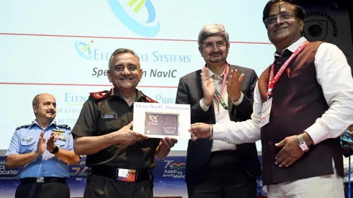
Indigenous Chip For Navic-based Satellite Navigation Launched

Indigenous Chip For Navic-based Satellite Navigation Launched

In a step towards expanding usage of indigenous satellite-based Navigation, NavIC, a chip that can form the core of the Navigation, Positioning and Timing applications developed by Elena Geo Systems, a Bengaluru-based space technology company, was unveiled at ht Deefence Space Symposium on Thursday. The chip works using Navigation with Indian Constellation (NavIC) or the ...
thehindu.com

Drones To Tally Canines

The Bruhat Bengaluru Mahanagara Palike (BBMP) is contemplating using drones to aid the upcoming dog census in the city. According to the officials, the technology is being actively considered as it will help cover a larger area in a short period and will give a better understanding of the stray population. “Property surveys in the ...
bangaloremirror.indiatimes.com

Govt To Introduce GPS-based Toll System In Six Months

The Indian government has announced plans to implement a GPS-based toll system within the next six months, which will replace traditional toll plazas, said Union minister Nitin Gadkari. This new system will rely on GPS technology to track and charge vehicles as they use highways and other roads, eliminating the need for physical toll booths ...

Indian Space Startup Pixxel Bags US Contract For Hyperspectral Imagery

Bengaluru-based space startup Pixxel has bagged a five-year contract for supplying technical hyperspectral imagery to United States’ National Reconnaissance Organization (NRO). Pixxel will provide technical hyperspectral imagery (HSI) remote sensing capabilities through modelling and simulation and data evaluation using its currently on-orbit pathfinder systems and future constellations. Last year, Pixxel had launched its hyper-spectral imaging ...
newsdrum.in

AirWorks Launches Geospatial Data Marketplace

AirWorks and Nearmap have announced that Nearmap will join AirWorks’ newly launched data marketplace, AirWorks Automate. The marketplace is intended to be an ecosystem of geospatial data providers that aims to bridge the gap between data access, processing, and analytics, uniting it in a single platform. Through the agreement, AirWorks and joint Nearmap-AirWorks customers will ...
spatialsource.com.au

US Aerospace Firm Lockheed Martin Space Looking To Work With ISRO, Indian Pvt Space Sector

American defence-aerospace firm Lockheed Martin’s Space division has been in talks with the Indian Space Research Organisation (ISRO) and the emerging Indian private space sector for collaboration, said a top official. This is a result of India’s space sector being reformed to permit private firms to carry out end-to-end space activities and seek government support ...
wionews.com
Filmus Firmó Acuerdo En Tecnología Satelital En La India Y Visitó Una Planta De Radioisótopos Creada Por Invap

Filmus Firmó Acuerdo En Tecnología Satelital En La India Y Visitó Una Planta De Radioisótopos Creada Por Invap

El ministro de Ciencia, Tecnología e Innovación, Daniel Filmus, firmó un acuerdo para comercializar imágenes satelitales del Saocom en la India y visitó la planta de producción de radioisótopos, en Mumbai, diseñada y construida por la empresa estatal rionegrina, radicada en Bariloche, Invap. Según detalló el Gobierno, en Nueva Delhi, Filmus, en representación de la ...
rionegro.com.ar
ISRO Set To Lift-off New User-friendly Launch Vehicle Designed For Smaller Satellites

ISRO Set To Lift-off New User-friendly Launch Vehicle Designed For Smaller Satellites

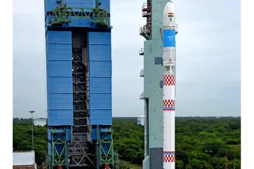
Indian Space Research Organisation will be making its second attempt to launch the Small Satellite Launch Vehicle. This second development flight — SSLV-D2 — will be launched from Sriharikota tomorrow at 9.18 a.m. SSLV-D2 will inject three satellites, namely EOS-07, Janus-1 and AzaadiSAT-2 into a 450 kilometre circular orbit during its 15-minute flight. Among the ...
indianarrative.com

IITTNIF And AGI Sign MoU For Geospatial Advocacy, Innovation, And Research

India’s Geospatial industry body – the Association of Geospatial Industries (AGI), and the Indian Institute of Technology (IIT) Tirupati’s technology innovation hub – the Navavishkar I-Hub Foundation – have signed a Memorandums of Understanding for collectively elevating the adoption of Geospatial technologies and applications in the country. Under their MoU for innovation-centric cooperation, AGI and ...
geospatialworld.net

Historical Heritage Sites In Kochi Geotagged

The Greater Cochin Development Authority (GCDA) has completed the first phase of geotagging its heritage and historic sites, especially in Fort Kochi and Mattancherry. GCDA chairman Chandran Pillai said that the first phase of the project, which identifies places, buildings, roads, and objects of historical heritage importance in Kochi, is complete. It was implemented with ...
newindianexpress.com

Esri & Texmin Sign MOU, Research And Innovation In Mineral Exploration Key Focus

Esri India and the TEXMiN Foundation have signed a Memorandum of Understanding (MoU) to establish a Geospatial Excellence Center at the Indian Institute of Technology (Indian School of Mines), Dhanbad. Esri India is the nation’s top provider of Geographic Information System (GIS) Software & Solutions. The research and innovation in spatial analytics & remote sensing ...
egov.eletsonline.com

Integrated App To Check Illegal Hoarding Menace

With illegal hoarding and advertisements emerging a big menace in the capital city, the Bhubaneswar Municipal Corporation (BMC) is working on developing a GIS-based integrated portal and mobile application to regulate display of advertisements effectively and increase revenue generation. Accordingly, the corporation has sought request for proposal (RFP) from stakeholders to finalise the agency and ...
newindianexpress.com
Esri India Launches Policy Map

Esri India Launches Policy Maps

Esri India, country’s leading Geographic Information System (GIS) Software & Solutions provider, today unveiled Policy Maps to facilitate data-driven policymaking in India. The announcement was made during Esri India’s annual flagship event, the User Conference. The objective of developing Esri India Policy Maps is to foster data-driven decision-making in policymaking. The Policy Maps have been ...
geospatialworld.net
Esri India UC 2023 Marches Ahead To Transform Communities Through GIS

Esri India UC 2023 Marches Ahead To Transform Communities Through GIS

Esri India, India’s one of the leading Geographic Information System (GIS) solutions provider, is back with its flagship conference, Esri India User conference (UC) in-person this year. The theme of this year’s conference is ‘GIS — Transforming Communities’. The conference is scheduled to be held on January 18, 2023 in Delhi and on January 20, ...
geospatialworld.net
“Geospatial Hackathon” Launched To Encourage Innovation And Start-ups In Indi

“Geospatial Hackathon” Launched To Encourage Innovation And Start-ups In India

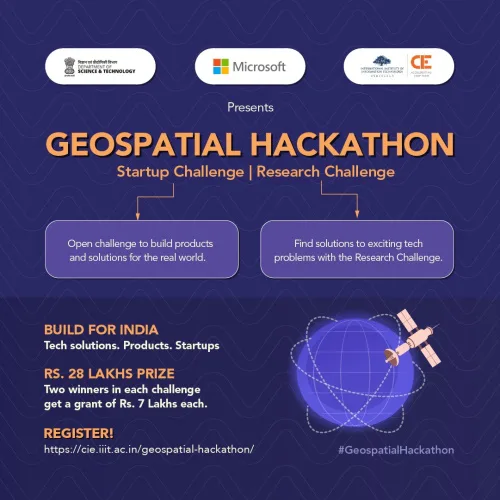
Dr. Jitendra Singh, the Union Minister for Science and Technology, launched the Geospatial Hackathon to encourage innovation and start-ups in India’s geospatial ecosystem. Speaking at the event in New Delhi, Dr. Singh stated that the hackathon’s goal was to encourage collaborations between the public and private geospatial sectors as well as to develop the nation’s ...
currentaffairs.adda247.com

KMC Starts GIS Mapping Of Ponds Within Its Jurisdiction

The Kolkata Municipal Corporation (KMC) is conducting Geographical Information System (GIS) mapping of all the ponds within its jurisdiction while it is also identifying lands which were previously water-bodies. The civic body presently is working on a war footing to protect ponds in the city, which are fast filling up for real estate development purposes ...
millenniumpost.in

Punjab Launching New Land Record System

The Punjab government is starting a new land record system, but the revenue record of 460 mouzas (villages) in the district of Rawalpindi is still incomplete. Upon this, the Board of Revenue (BoR) has written a letter to the deputy commissioner to complete the scanning of ‘Massavi’ (details of land ownership) by January 9, as ...
dawn.com

Policy To Make Adoption Of Indian Standard Time Mandatory On Anvil: Government Official

The government is planning to come out with a comprehensive policy for mandatory adoption of Indian Standard Time (IST) nationwide, a senior consumer affairs ministry official said. The purpose is to ensure synchronization of all networks and computers to IST and adoption of IST by Telecom Service Providers, Internet Service Providers, power grids, banks, stock ...
outlookindia.com

View From India: National Geospatial Policy Promises Citizen-centric Approach

A 13-year guideline has been formulated for the development of the geospatial data industry in the country. A national framework is also in place. The government plans to develop a geospatial knowledge infrastructure by 2030. This is expected to happen with the establishment of an Integrated Data and Information Framework. By 2035, it is envisioned ...
eandt.theiet.org
Esri India Launches Carbon Footprint Awareness App

Esri India Launches Carbon Footprint Awareness App

Leading Geographic Information System (GIS) solutions provider Esri India announced on Tuesday the launch of an app in Hindi and English to enhance awareness about carbon footprint at an individual level. A simple to use app ‘Carbon Jagruk’ or ‘CarbonAware’ enables citizens to estimate and reduce their carbon footprint requires no login or download and ...
deccanchronicle.com
All Roads In Telangana To Be Mapped By Remote Sensing

All Roads In Telangana To Be Mapped By Remote Sensing

All roads in Telangana would be mapped with the help of satellite remote sensing systems to help in better planning and maintenance, Vice-Chairman of the State Planning Board B. Vinod Kumar said on Monday. The mapping would include length of the roads, width of roads at different locations, their conditions, existing culverts and bridges. The ...
thehindu.com

Mexico Seeks India’s Support In Building And Launching Remote Sensing Satellite

The chief of the Mexican space agency has sought the support of India in building and launching a remote sensing satellite. The Indian Space Research Organisation (ISRO) will work on this proposal with the support of India’s External Affairs Ministry. This request from Mexico is part of the ongoing cooperation activities between India and Mexico ...
wionews.com
GIS Energy Map For Resource And Infra Planning

GIS Energy Map For Resource And Infra Planning

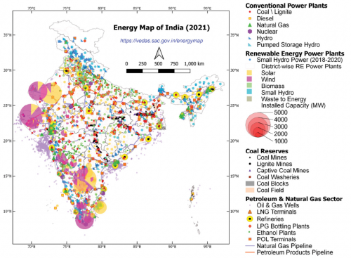
The Geospatial Energy Map of India by the NITI Aayog, in collaboration with ISRO, identifies and locates all primary and secondary sources of energy along with their transportation and transmission networks. The idea is to develop a web-GIS-based information system for the visualisation of spatial and non-spatial data associated with conventional energy sources in India ...
geospatialworld.net

ISRO To Develop “Spatial Data Infrastructure Geoportal ‘Geo-ladakh’ For Ut-ladakh”

Union Minister of State (Independent Charge) Science & Technology; Minister of State (Independent Charge) Earth Sciences; MoS PMO, Personnel, Public Grievances, Pensions, Atomic Energy and Space, Dr Jitendra Singh today informed that Government of UT – Ladakh has approached the Indian Institute of Remote Sensing (IIRS), a unit of Indian Space Research Organisation (ISRO) for ...
indiaeducationdiary.in

India’s Latest Earth Observation Satellite Starts Serving Images

The Earth Observation Satellite-06 launched by the Indian Space Research Organisation on November 26 has started serving images, the national space agency said on Wednesday. Bengaluru-headquartered ISRO shared on Twitter the first-day images received on Tuesday at National Remote Sensing Centre, Shadnagar, Telangana, covering the Himalayan region, Kutch region of Gujarat and the Arabian Sea. ...
thehindu.com
India Wants Smartphones To Support Home-grown Navigation System Navic Starting 2025; RTI Reveals

India Wants Smartphones To Support Home-grown Navigation System Navic Starting 2025; RTI Reveals

In September, Reuters reported that the Indian government is pushing smartphone manufacturers like Samsung, Oppo, Apple, and Xiaomi to make their smartphones compatible with Navigation with Indian Constellation (NavIC), the home-grown alternative to US’s Global Positioning System (GPS). A recent RTI response obtained by journalist Aroon Deep of Entrakr sheds more light on the government’s ...
medianama.com

Oceansat-3 To Be Launched On Nov 26: Jitendra Singh

India will launch the Oceansat-3 satellite on November 26, Earth Sciences Minister Jitendra Singh said on Tuesday. Singh said the Ministry of Earth Sciences has taken the notion of ‘marine surveillance’ to a new level, where space applications are also being deployed to share the valuable inputs with the security agencies, an official statement said. ...
theprint.in