Geomaticians

São Paulo

Prefeitura Atualiza Imagens Do Mapa Digital Da Cidade

A Prefeitura de São Paulo, por iniciativa da Secretaria Municipal da Fazenda, em parceria com a Secretaria Municipal de Urbanismo e Licenciamento (SMUL), disponibiliza ao público a partir desta quarta-feira, dia 23, no portal GeoSampa, novas imagens ortorretificadas da capital paulista. O novo mapeamento fotográfico do município foi realizado em 2020, com perfilamento laser que ...
prefeitura.sp.gov.br
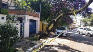
Risk Of Urban Tree Falls In São Paulo Is Influenced By Building Height And Neighborhood Age, Study Shows

Risk Of Urban Tree Falls In São Paulo Is Influenced By Building Height And Neighborhood Age, Study Shows

According to a study in the journal Urban Forestry & Urban Greening, the factors that most influence and increase the risk of tree failure in São Paulo (the capital of São Paulo state in Brazil) are the height of nearby buildings and the age of the neighborhood. Sidewalk width and tree height are the next ...
phys.org