Geomaticians

Belgium

Planetary Boundary Layer Revealed Satellites Illuminate Atmospheric Mysteries

Planetary Boundary Layer Revealed: Satellites Illuminate Atmospheric Mysteries

Unlocking the secrets of Earth’s planetary boundary layer (PBL), a pivotal zone influencing air quality and climate, a new study offers unprecedented insights into atmospheric thermal contrasts (TC). By scrutinizing satellite data, researchers have shed light on how the surface-to-atmosphere temperature gradient affects the detection of atmospheric pollutants. The endeavor to keep tabs on and ...
eurekalert.org

Pythagoras Launches Pointorama For Streamlined Point Cloud Management

Pythagoras has released Pointorama, a groundbreaking cloud-based platform designed to simplify point cloud management. The official launch took place at GeoBusiness 2024, which was held on 5-6 June in London. Pythagoras is a provider of innovative software solutions for land surveyors and contractors. In today’s rapidly evolving field of land surveying, the quest for efficiency ...
gim-international.com
EuroGeographics And BKG Sign Agreement For Pan-European Datasets

EuroGeographics And BKG Sign Agreement For Pan-European Datasets

Germany’s Federal Agency for Cartography and Geodesy (BKG) will continue to manage production of pan-European datasets after signing a new agreement with EuroGeographics. As a result, BKG is responsible for three open datasets available via the Open Maps For Europe (OME) user interface, as well as a database of administrative boundaries and 1:250 000 topographic ...
geospatialworld.net
New 'Digital Twin' Earth Technology Could Help Predict Water-Based Natural Disasters Before They Strike

New ‘Digital Twin’ Earth Technology Could Help Predict Water-Based Natural Disasters Before They Strike

The water cycle looks simple in theory—but human impacts, climate change, and complicated geography mean that in practice, floods and droughts remain hard to predict. To model water on Earth, you need incredibly high-resolution data across an immense expanse, and you need modeling sophisticated enough to account for everything from snowcaps on mountains to soil ...
phys.org
Septentrio Launches Antarx GNSS Smart Antenna For Machine Automation Applications

Septentrio Launches Antarx GNSS Smart Antenna For Machine Automation Applications

Septentrio has introduced the AntaRx smart antenna, catering to machine automation needs in industries such as construction, precision agriculture, and logistics. The smart antenna is housed in a rugged casing, designed to endure shocks and vibrations in challenging industrial environments. The multi-frequency receiver aims for high-accuracy RTK positioning down to the centimeter level. The AntaRx ...
insidegnss.com

Les Enfants Des Campagnes Ont Les Os Plus Solides Que Les Enfants Des Villes

Tout au long de leur croissance, et jusqu’à l’âge adulte, les enfants construisent leur capital osseux à l’aide de plusieurs apports : la génétique certes, mais aussi une bonne alimentation et un cadre de vie adapté. Mais selon une nouvelle étude menée sur de petits belges, le fait de profiter d’un environnement vert et d’être ...
doctissimo.fr
Septentrio Introduces New Open-Source Projects

Septentrio Introduces New Open-Source Projects

Septentrio has introduced two new open-source hardware projects available to integrators of satellite-based positioning. By expanding their ecosystem of open-source hardware and software, Septentrio aims to make reliable GNSS positioning more accessible to integrators and developers. The first project, mosaicBus, is a reference design of a board compatible with mikroBUS add-on board standards primarily used ...
gpsworld.com
Photogrammetry App In Major New Release Of Smart Drone Survey Software

Photogrammetry App In Major New Release Of Smart Drone Survey Software

Virtual Surveyor has added drone photogrammetry capabilities to the latest release of its popular Virtual Surveyor smart drone surveying software. The new Terrain Creator app photogrammetrically processes drone photos to generate survey-grade terrains which then transfer seamlessly into the traditional Virtual Surveyor workspace where the real survey work can be performed. “Virtual Surveyor software is ...
amerisurv.com
Une Carte Des Temps Piétons Pour Uccle Centre “On Veut Relativiser Les Temps De Marche Et Ramener Du Passage Devant Les Commerces”

Une Carte Des Temps Piétons Pour Uccle Centre : “On Veut Relativiser Les Temps De Marche Et Ramener Du Passage Devant Les Commerces”

”Nous sommes tous piétons à un moment.” Partant de ce constat, Sébastien Rochedy s’est penché sur la question du vécu des piétons et surtout sur l’amélioration de l’expérience de la marche. L’inspiration lui est venue de France. Lors d’un voyage, il remarque des panneaux qui indiquent le temps de trajet à pied pour atteindre certains ...
dhnet.be

Final Call For Abstracts For Fourth International Workshop On Spatial Data Quality

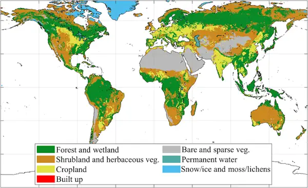
Submissions covering a wide range of topics, including ways in which data providers can ensure that their data continues to be trusted, ways of bringing together data from multiple sources to ensure seamless, high-quality datasets, and ways to communicate the quality, relevance and content to users, are invited by 17 July. The event, to be ...
directionsmag.com

Bruxelles Lance Enfin Sa Stratégie De Smart City

La Ville de Bruxelles a présenté vendredi sa stratégie de déploiement du digital à tous les étages de la vie collective à travers le concept de “smart city”, également dans le viseur de nombreuses villes européennes. La Ville de Bruxelles a présenté vendredi sa stratégie de déploiement du digital à tous les étages de la ...
Thermographie Aérienne Des Toitures Garantir Le Respect De La Vie Privée Et Éviter Les Dérive

Thermographie Aérienne Des Toitures : Garantir Le Respect De La Vie Privée Et Éviter Les Dérives

Dès les données thermographiques récoltées et traitées, la volonté est de pouvoir proposer (gratuitement) aux citoyens les informations utiles permettant d’entreprendre des travaux d’isolation. Les communes concernées tout comme la province du Brabant wallon, peuvent aussi profiter de ces relevés pour améliorer la performance énergétique des bâtiments publics. Reste deux questions qui suscitent d’ailleurs de ...
rtbf.be

New Horizon Europe Project ‘Evoland’ Sets Off

A consortium under the lead of VITO officially launched the new Horizon Europe project EvoLand in Leuven (Belgium). EvoLand will develop and test new and innovative methods and algorithms and implement a bundle of candidate Copernicus Land Monitoring Service prototypes. This will be realised by integrating novel EO and in-situ data with the latest Machine ...
geospatialworld.net

Au Rwanda, Un Nouvel Outil Cartographie La Teneur En CO2 Des Arbres

On connaît l’importance des écosystèmes forestiers pour séquestrer le carbone et lutter contre le dérèglement climatique. Mais la quantité de dioxyde de carbone que les arbres peuvent absorber reste difficile à évaluer de manière précise, ce qui entrave l’efficacité de mesures concrètes visant à limiter le réchauffement de la planète. Des chercheurs de l’université de ...
rtbf.be

Hexagon And OSASI Technos Partner To Develop Disaster Management And Prediction Solutions

Hexagon’s Safety, Infrastructure & Geospatial division and OSASI Technos Inc. have announced a partnership to deliver next-generation disaster management and monitoring solutions. Using 3D visualization capabilities, governments will be able detect, predict and simulate impending disasters, enabling them to better plan for and respond to impending disasters, enabling them to better plan for and respond ...
geospatialworld.net