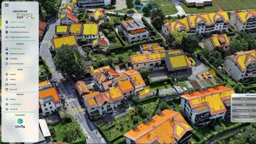
A new approach uses aerial imaging to generate 3D models of cities and regions with advanced precision, enabling urban planners to incorporate full-scale designs of all types of architectural and urban structures. Two months ago, EPFL spin-off Uzufly moved into The Garage, a business incubator at EPFL Innovation Park where startups can grow and expand. The young firm has created virtual-reality technology that allows urban planners to map out and communicate on their development plans. Théo Benazzi, Uzufly's co-founder and CTO, is heading up efforts to produce these high-precision digital twins. "We basically use the same technology as Google Earth—that is, aerial photography," he says. "But while Google uses airplanes to take huge numbers of pictures at high altitudes, we use drones that have smaller cameras and capture images much closer to the ground. That's why we can generate 3D models at the level of a neighborhood or an entire city."