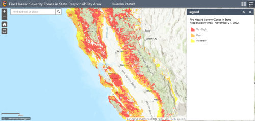
The California Department of Forestry and Fire Protection (Cal FIRE) has granted stakeholders an additional 60 days to comment on the state’s draft Fire Hazard Severity Zone Map for rural, unincorporated areas (State Responsibility Area). The move was made in response to a request for more time and clarity from the League of California Cities and others. The draft map comprehensively ranks the State Responsibility Area based on the likelihood of wildfires and does not include cities or large urban areas. The methodology and data behind the map will inform the upcoming Local Responsibility Area map, which deals entirely with cities. The public comment period now totals 110 days and closes on April 4, 2023. Information about how to submit public comment is available on Cal FIRE’s website. Cal FIRE also released new information about the data input relied upon for the maps.