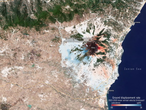
thanks to Europe's environmental Copernicus program and the Sentinel-1 radar satellite mission, the first Europe-wide subsidence and soil movement analysis service is available to the public. The new European Ground Motion Service, the latest offering of the Copernicus Land Monitoring Service and implemented by the European Environment Agency, provides free and accessible ground motion data to anyone who wishes to use it. Based on radar data from Copernicus Sentinel-1 satellite mission, the service provides information on the motion of land, structures and infrastructure in Copernicus Participating States. Its aim is to give users reliable information on ground motion at a local, regional or national scale. Radar images—as provided by the Sentinel-1 mission's advanced C-band synthetic aperture radar—are the best way of tracking land subsidence and structural damage.