Two years ago, Ecopia received almost $1 million from the Ontario Vehicle Innovation Network (OVIN) to fund this map’s development. The work was done using artificial intelligence technology to plot crucial information about Toronto’s land cover and transportation features. The data is essential to supporting safe and effective AV transportation and navigation. Ecopia also invested $2 million of its money into the project.
“AVs require various geospatial technologies to operate effectively and safely, including a foundational reference dataset of real-world features,” explains a spokesperson for Ecopia AI in an email statement to Electric Autonomy. “AVs cannot use open-source data or publicly available navigation maps as they are not created using consistent data specifications, which creates issues of completeness, accuracy and currency. This can cause potentially dangerous situations when navigating through a city.”
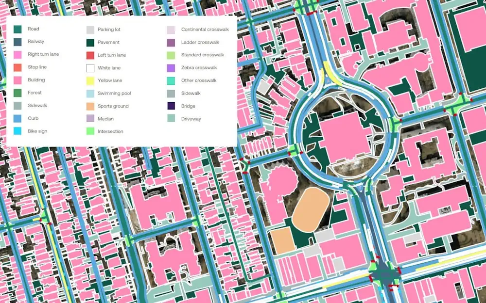
To create the map, Ecopia gathered high-resolution street views and aerial images of road networks. The detail encompasses lane delineation, pedestrian features and buildings in 3D. “These [details] are essential for training, testing, and deploying AVs as they show where the vehicle can go and what it should avoid,” says the spokesperson.
One example of the precision involved: there are more than 300 types of road signs in Toronto and over 330,000 individual road signs on the map. “This mapping data provided by Ecopia is a digital source of truth for the real world, which will act as a base layer to build smart city solutions on top,” says the spokesperson. Ecopia’s digital map of Toronto is now available for the city, manufacturers, regulators and other agencies to license. (Ecopia currently works with other institutions and organizations on similar initiatives. These include the Canadian government, Chicago Metropolitan Agency for Planning and the World Bank.) “We just completed this map and it is now in post-delivery testing with the city,” says the spokesperson. But the data obtained from the digital map of Toronto also has various other applications, says Ecopia. These scenarios include public safety, stormwater management and planning for sustainable infrastructure.