The geology along Ecuador’s Coca River is moving in fast-forward. In a scientific field where natural wonders form over millennia, but natural disasters occur in minutes, speed is less than desirable. Over the last four years, the river and its surrounding area within the Amazon basin have experienced a lava dam collapse, 500 million tons of sediment displaced down the river, landslides and the formation of what some have dubbed the “Ecuadorian Grand Canyon.“
In the wake of these events, bridges and pipelines have collapsed, collapsing riverbanks have threatened homes and businesses, and Ecuadorian engineers feared the rapidly dropping headwaters of the river could take out a hydropower plant that provides electricity to one-third of the country.
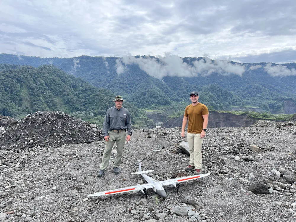
These impacts and threats brought together an international group of experts, including Matt Larson and Brandon Stockwell from the Autonomous Systems group at the Department of Energy’s Oak Ridge National Laboratory. Larson and Stockwell used drones to map a previously unstudied section of the Coca River. The team’s high-resolution visual, thermal and multispectral imagery will be used to update Ecuador’s national maps and create better engineering models to mitigate the erosion.
To better understand the gravity of their mission, let’s rewind. On Feb. 2, 2020, the San Rafael waterfall disappeared. Journalists and geologists have used various words to describe what happened to Ecuador’s largest waterfall four years ago. Whether the natural wonder “failed,” “collapsed” or was “abandoned,” the singular phenomenon on the Coca River that day began a cascade of geographic events that continue to impact the country’s landscape, infrastructure and security. Just upstream of the lava dam, a sinkhole formed in the riverbed. On Feb. 2, 2020, the sinkhole roof collapsed, dropping the river flow below the lava dam rather than over it. The river continued to flow, but one of Ecuador’s greatest tourist attractions was lost forever.
The sinkhole collapse left behind a sharp change in the riverbed slope, known as a headcut, just upstream of the lava dam. Freshly exposed riverbed material at a headcut is unstable, causing rock and soil to erode in the opposite direction of water flow. In the first 18 months following the waterfall event, the Coca River’s headcut regressed 12 kilometers, just over 7.4 miles, upstream as the water washed away the earth beneath it. If the erosion had continued at this rate, Ecuador’s largest hydropower plant, located just 19 kilometers, or 11.8 miles, upstream of the waterfall, would likely have lost operation. The Coca Codo Sinclair Hydropower Facility supplies 26% of the country’s electricity.
With a two-pronged predicament threatening a major utility source, in addition to infrastructure and natural resources, the Ecuadorian government and the U.S. Ambassador to Ecuador called for help. Reinforcements included McConnell’s USACE team as well as experts from other national organizations such as the National Geospatial-Intelligence Agency, or NGA, to help mitigate the eaects of this unique phenomenon. Additionally, the U.S. Geological Survey started helping develop a sediment monitoring plan to better characterize the soils in the area, and the U.S. Department of Agriculture conducted soil jet testing to determine soil erodibility.
Larson is a research scientist in ORNL’s Autonomous Systems group with a background in geology and geospatial technology. The Ecuadorian government, USACE and NGA had done some initial surveying after the San Rafael waterfall collapse, but ORNL’s capabilities in the field and in the lab brought unmatched capabilities to catch up with Mother Nature. The team planned to map the previously unmapped stretch of the Coca River, spanning 100 kilometers, or 62 miles.
Though the team had the right people in place, their work was cut out for them: Mapping 100 kilometers of a river in 15 days with two drones and zero existing maps was no small feat. The constant cloud cover over the Coca River is so thick, no helpful satellite imagery existed. The unyielding vegetation in the Amazon basin also made map-making seemingly impossible. “It’s always cloudy. It’s always raining. Satellite imagery isn’t good,” Larson said. “Drones are the only way to map this area.“
The team completed the mission of mapping over 100 kilometers, around 62 miles, of the Coca River in under 15 days. Larson returned to the U.S. and began processing the two terabytes of data the drones gathered. The high-performance computing capabilities at ORNL were crucial to this part of the mission. These models will help CELEC and their partners to outpace the erosion and sedimentation rates. “It will really help them understand spots with a high potential for a landslide,” Larson said.