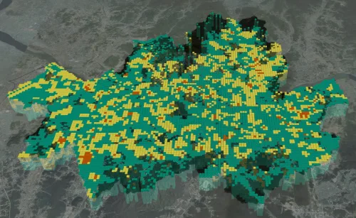
Liquefaction is a phenomenon in which the ground surface loses its stiffness and acts like a liquid due to the repeated application of large forces generated by an earthquake. It can cause buildings or other structures to tilt or collapse, taking a heavy toll in terms of lives and property. A research team (Dr. Han, Jin-Tae, Dr. Kim, Jongkwan) at KICT's Department of Geotechnical Engineering Research developed a 3D liquefaction hazard map that is connected to Korea's geotechnical information portal, a database system for ground data. The map displays liquefaction risks by region in 3D upon the occurrence of an earthquake. The research team calculated the factor of safety against liquefaction by comparing the forces applied to the ground generated by an earthquake and the soil's resistance to liquefaction. For the calculation of regional liquefaction resistance, the team used the database of the geotechnical information portal built by KICT. It then rendered the 3D liquefaction hazard map by visualizing the safety factors by ground depth.