Geomaticians

20

Conferenza Nazionale Di Geomatica E Informazione Geografica #ASITA2024 Primo Annuncio E Call For Abstract

ASITA è il luogo dove professionisti, docenti, ricercatori, tecnici e professionisti, soggetti istituzionali e territoriali, società commerciali e più in generale tutti coloro che operano nei diversi campi della Geomatica possono confrontarsi su temi specifici, promuovendo una visione multidisciplinare e integrata del settore della Geomatica nel tentativo di delineare le cosiddette “best practices” utili ad ...
rivistageomedia.it

Nueva Alianza Entre Organismos Nacionales Para Mejorar La Información Geográfica Marítima Y Terrestre

El Ministerio de Transportes y Movilidad Sostenible ha anunciado la firma de un protocolo con el Ministerio de Defensa, específicamente con la Armada, para fomentar la colaboración entre el Instituto Geográfico Nacional (IGN), su Centro Nacional de Información Geográfica (CNIG) y el Instituto Hidrográfico de la Marina (IHM). Esta alianza estratégica busca compartir y mejorar ...
elestrechodigital.com

Esri Se Asocia A Acutel Para Hacer Accesible Su Tecnología Geoespacial A Los Operadores De Telecomunicaciones Neutros Y Locales

Esri, empresa líder en tecnología geoespacial, ha firmado un acuerdo de colaboración con Acutel, la Asociación Nacional de Operadores de Telecomunicaciones y Televisión Local de España, entidad que aglutina a casi 250 compañías que ofrecen servicios de internet, telefonías fija y móvil y televisión, y cuyo objetivo es que los operadores de telecomunicaciones locales puedan ...
dirigentesdigital.com
Flightradar24’s New GPS Jamming Map

Flightradar24’s New GPS Jamming Map

We’re pleased to release our new GPS jamming map tool. The new map allows users to view areas of GPS jamming and interference around the world in an easy to understand visual format. As part of the ADS-B messages we receive from each aircraft, the Navigation integrity category (NIC) encodes the quality and consistency of ...
flightradar24.com

Saudi Ministry Launches GIS-Enabled Digital Platform For Water Management

The Ministry of Environment, Water, and Agriculture has announced a significant step forward in water management and planning by signing a contract to establish a geographical information system (GIS) for water planning. This initiative aims to create a smart water digital platform aligning with international best practices for the water sector within the Kingdom. Dr. ...
zawya.com

ESA-JRC Opens Registration For GNSS Summer School

The European Space Agency (ESA) and the European Commission’s Joint Research Centre (JRC) are collaborating to host the 15th edition of the International Summer School on Global Navigation Satellite Systems (GNSS). The course is scheduled to take place in Novo Mesto, Slovenia, from July 15 to 26, 2024. The summer school invites graduate students, Ph.D. ...
gpsworld.com

California Is Finally Digitizing Its 100-Year-Old Paper Water Rights

In a Sacramento office building, university students carefully scan pieces of paper that underpin California’s most contentious and valuable water disputes. One by one, they’re bringing pieces of history into the digital era, some a century old and thin as onion skin. The massive undertaking will unmask the notoriously opaque world of California water. Right ...
insider.govtech.com
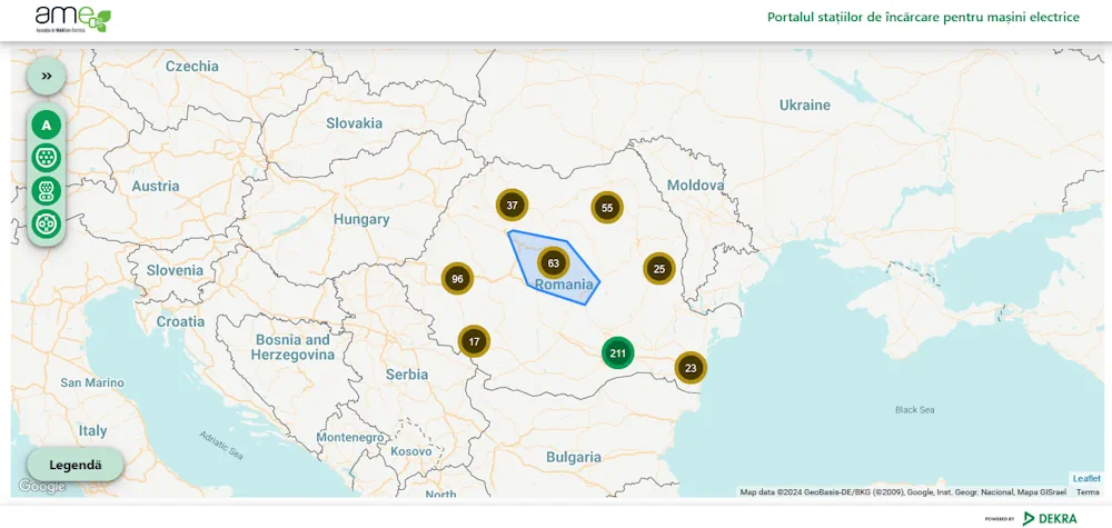
Romania’s Energy Ministry Makes Map Of EV Charging Points Available

Romania’s Energy Ministry Makes Map Of EV Charging Points Available

A map with charging points for electric cars was recently unveiled by Romania’s Energy Ministry. The map is featured on the website of the institution, and was made in partnership with local authorities across the country. Romanian energy minister Sebastian Burduja said that the map is part of the EU-wide project of reaching 75 million ...
romania-insider.com