Geomaticians

March

X1 Pro GNSS Receiver Enhances Surveying Precision

X1 Pro GNSS Receiver Enhances Surveying Precision

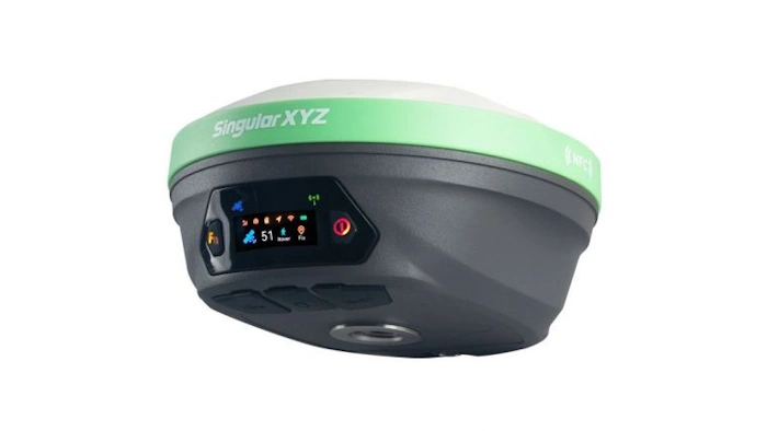
SingularXYZ has presented its latest innovation for geospatial professionals: the X1 Pro GNSS receiver. This new device aims to refine precision in surveying technology with a range of features tailored to streamline operations and improve accuracy. Central to the X1 Pro is its enhanced HD colour screen, providing users with clear visibility for monitoring status ...
gim-international.com

S. Korea, Japan To Cooperate In Developing Satellite Navigation System

South Korea and Japan will collaborate on the development and operation of regional satellite navigation systems in East Asia, Seoul’s science ministry said Tuesday. The two countries signed a memorandum of cooperation (MOC), designed for practical cooperation in developing and operating their respective satellite systems in the region, according to the Ministry of Science and ...
en.yna.co.kr

Geospatial Mapping And AI To Help Tackle Energy Gap In Africa

Energy modellers and researchers have developed a geospatial mapping model they say can help address the electricity access gap in Africa. The model has been developed by the International Energy Agency (IEA), researchers at Massachusetts Institute of Technology, University of Massachusetts Amherst and Electricity Growth and Use In Developing Economies. By mapping which buildings are ...
esi-africa.com

New PSGA Data Will Help Speed Up Emergency Response Times

A new selection of location datasets, including two new products, have been released today (Thursday 28 March) as part of the Public Sector Geospatial Agreement (PSGA). The new data and products have been delivered by Ordnance Survey (OS) and are set to support customers across a range of markets, including the emergency services, sustainability, land ...
gov.uk

Dublin Urban Rivers Life Project Selects ESRI To Reduce Levels Of Wastewater

Geographic information systems (GIS) provider Esri Ireland has been chosed by Dublin Urban Rivers Life (DURL) project to help prevent preventing circa 13 million litres of polluted wastewater from entering Dublin rivers annually. DURL is a joint venture between South Dublin and Dún Laoghaire-Rathdown County Councils, with funding received from the EU Life Programme. It ...
techcentral.ie
HKU Remote Sensing And Landscape Scholars Reveal Global Wildfire Risk Trends In Wildland-Urban Interface Areas (1985-2020)

HKU Remote Sensing And Landscape Scholars Reveal Global Wildfire Risk Trends In Wildland-Urban Interface Areas (1985-2020)

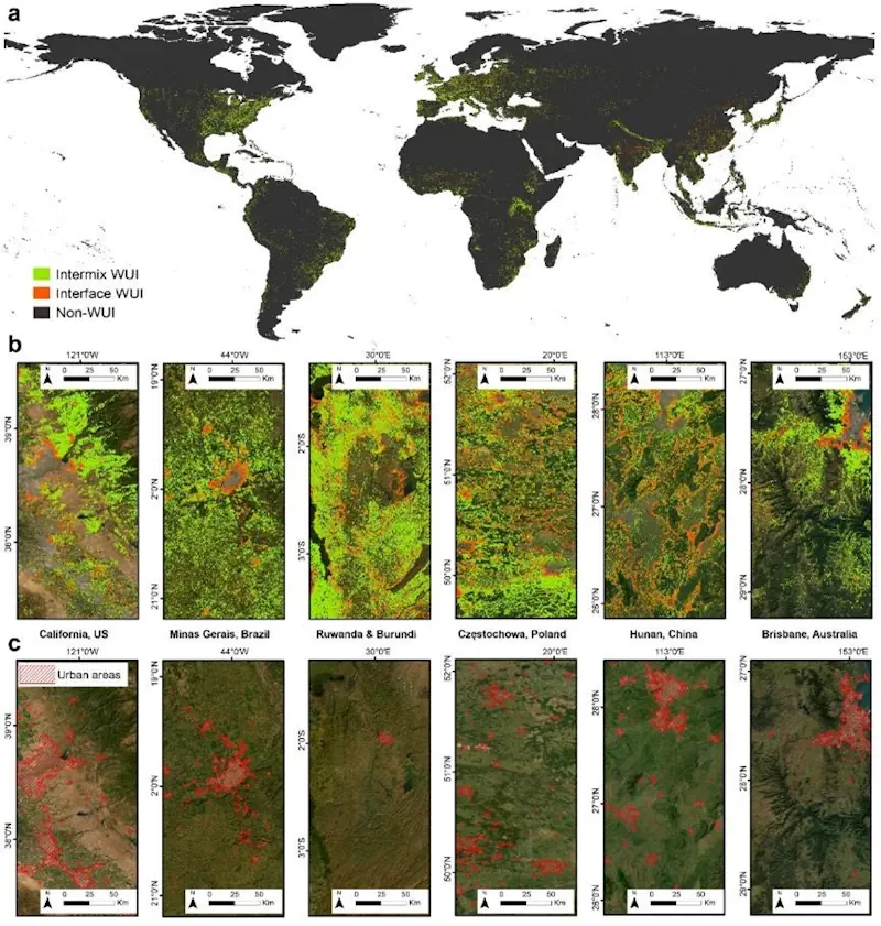
Wildfires present complex socio-economic and ecological challenges, as they devastate vegetation, endanger communities, and cause extensive environmental, wildlife, and human health impacts. These consequences include severe air pollution and soaring firefighting costs. Wildland-Urban Interface (WUI) areas, which are transition zones between wilderness and human-developed land, are particularly susceptible to wildfires. The risk is heightened due ...
eurekalert.org

Geospatial Commission-Funded Tool Demonstrates Potential For AI To Transform Decisions About Land Use

The Geospatial Commission, part of the Department for Science, Innovation and Technology (DSIT), has partnered with The Alan Turing Institute to explore the role that artificial intelligence (AI) can play in long-term decisions about how to use land. The UK is facing significant and competing pressures for its land. Advances in spatial data science and ...
gov.uk

Organic Farms Can Have Mixed Effects On Pesticide Use Depending On Their Neighbors

Organic agriculture may be as old as dirt, but that doesn’t mean its impacts are fully understood. A team of scientists in the United States and Canada are doing their part to change that. Researchers at UC Santa Barbara, University of British Columbia, and University of Colorado Boulder discovered that organic farming significantly affects the ...
news.ucsb.edu
Estimating Coastal Water Depth From Space Via Satellite-Derived Bathymetry

Estimating Coastal Water Depth From Space Via Satellite-Derived Bathymetry

With the development of shipborne echo sounders in the early 20th century, bathymetric surveys saw massive leaps in both accuracy and convenience. However, even with modern echo sounders, there are still many hardships to overcome when conducting bathymetric surveys. These include high cost, unpredictable weather, high ship traffic, and potential geographic or diplomatic issues, to ...
eurekalert.org

제주 ‘전자 지도’ 만든다···‘날아다니는 차’ 도입 코앞

제주에서 도심항공 교통(UAM)의 밑그림이 될 ‘지도’가 그려진다. 제주특별자치도는 국토교통부가 주관하는 ‘2024년 고정밀 전자지도 구 축 챌린지’ 사업기관에 선정돼 도시계획·개발, 지하시설물 매설 등 각종 사 업의 기본도로 활용되는 전자지도를 구축한다고 21일 밝혔다. 고정밀 전자지도는 도로, 건물, 하천 등 다양한 인공지물과 자연 지형을 일정한 축척에 따라 기호와 문자, 속성 등으로 표현한 디 지털 지리정보다. 국내에서 제작되는 수치지도 ...
news.zum.com
Estudo Mostra Que Área De Futuro Polo Agrícola Concentrou 76% Do Desmatamento De Três Estados Amazônicos

Estudo Mostra Que Área De Futuro Polo Agrícola Concentrou 76% Do Desmatamento De Três Estados Amazônicos

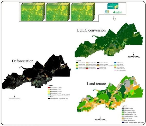
Enquanto o governo federal discute a criação de um polo agrícola na confluência entre Amazonas, Acre e Rondônia – popularmente conhecida pelo acrônimo Amacro –, o desmatamento nos municípios da região avança e já representa 76,5% do total da área devastada nos três Estados entre 2018 e 2022. A conclusão é de um estudo publicado ...
gizmodo.uol.com.br

NVIDIA Announces Earth Climate Digital Twin

To accelerate efforts to combat the $140 billion in economic losses due to extreme weather brought on by climate change, NVIDIA today announced its Earth-2 climate digital twin cloud platform for simulating and visualizing weather and climate at unprecedented scale. Part of the NVIDIA CUDA-X™ microservices, announced separately today, Earth-2’s new cloud APIs on NVIDIA ...
nvidianews.nvidia.com
Crean Plataforma Para Democratizar La Información Histórica De Bogotá De Hace Más De Dos Siglos

Crean Plataforma Para Democratizar La Información Histórica De Bogotá De Hace Más De Dos Siglos

Con la intención de acercar y facilitar el acceso a toda la información de Bogotá, la Sociedad de Mejoras y Ornato de Bogotá creó la plataforma digital DataCivilidad, una herramienta que recoge cientos de miles de datos de la capital desde hace más de dos siglos para que, tanto personas naturales como organizaciones estatales y ...
diariodelcauca.com.co
Introducing Floorlocator, A System That Enhances Indoor Navigation

Introducing Floorlocator, A System That Enhances Indoor Navigation

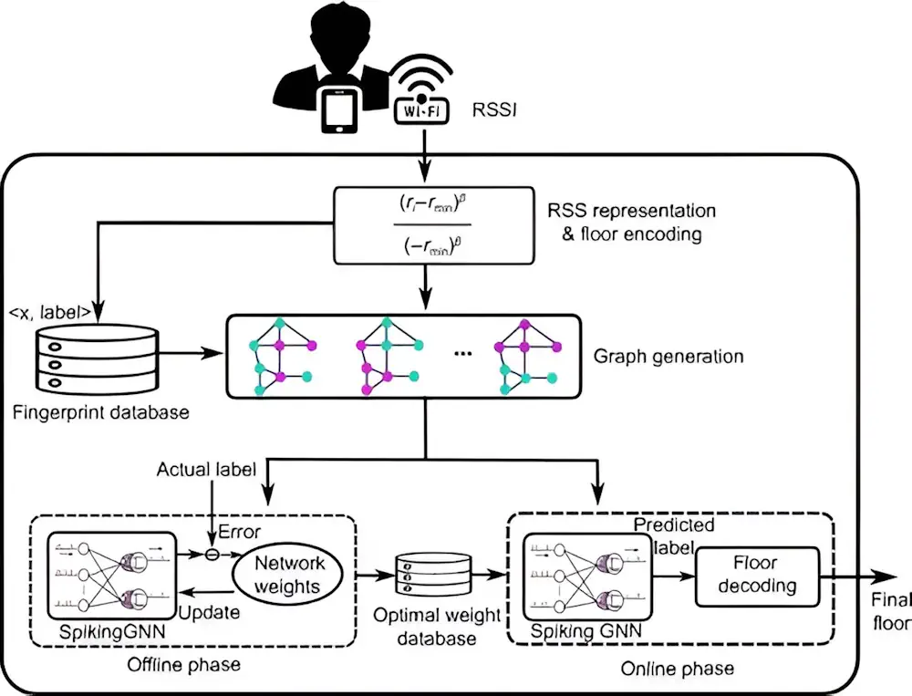
Indoor positioning is transforming with applications demanding precise location tracking. Traditional methods, including fingerprinting and sensor-based techniques, though widely used, face significant drawbacks, such as the need for extensive training data, poor scalability, and reliance on additional sensor information. Recent advancements have sought to leverage deep learning, yet issues such as low scalability and high ...
techxplore.com
Investigadores De La UJA Y Guatemala Colaboran En El Desarrollo De Técnicas Que Ayuden A Documentar Y Preservar El Patrimonio

Los grupos de investigación ‘Informática Gráfica y Geomática’ y ‘Tecnologías Avanzadas en Ingeniería Civil: Construcción y Transporte Terrestre’ de la Universidad de Jaén mantienen desde hace unos años una intensa colaboración en materia de investigación y docencia con la Facultad de Arquitectura de la Universidad de San Carlos de Guatemala (FARUSAC). Fruto de esta cooperación ...
ondacerojaen.es
Detecting Heavy Precipitation Events Directly With GPS Data

Detecting Heavy Precipitation Events Directly With GPS Data

An exceptionally severe storm swept over Zurich on 13 July 2021 shortly before 2 a.m., with howling squalls, constant lightning and torrential rain that awakened people with a start. Benedikt Soja, Professor of Space Geodesy, got little sleep that night. “It was one of the most severe storms I’ve ever witnessed. I woke up in ...
phys.org
ESA Will Launch Genesis System To Measure Earth With Millimeter Precision

ESA Will Launch Genesis System To Measure Earth With Millimeter Precision

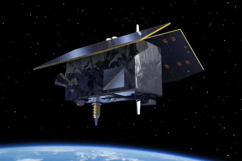
European Space Agency (ESA) allocated €76.6 million to develop the Genesis orbital observatory, which will be able to determine the position of objects on Earth with an accuracy of one millimeter. Another €156.8 million has been allocated for the launch of a low-orbit constellation of devices to test and improve the reliability of satellite navigation. ...
technewsspace.com
Trimble And Radiodetection Combine Survey-Grade Positioning With Underground Utilities Locating Measurement Workflows

Trimble And Radiodetection Combine Survey-Grade Positioning With Underground Utilities Locating Measurement Workflows

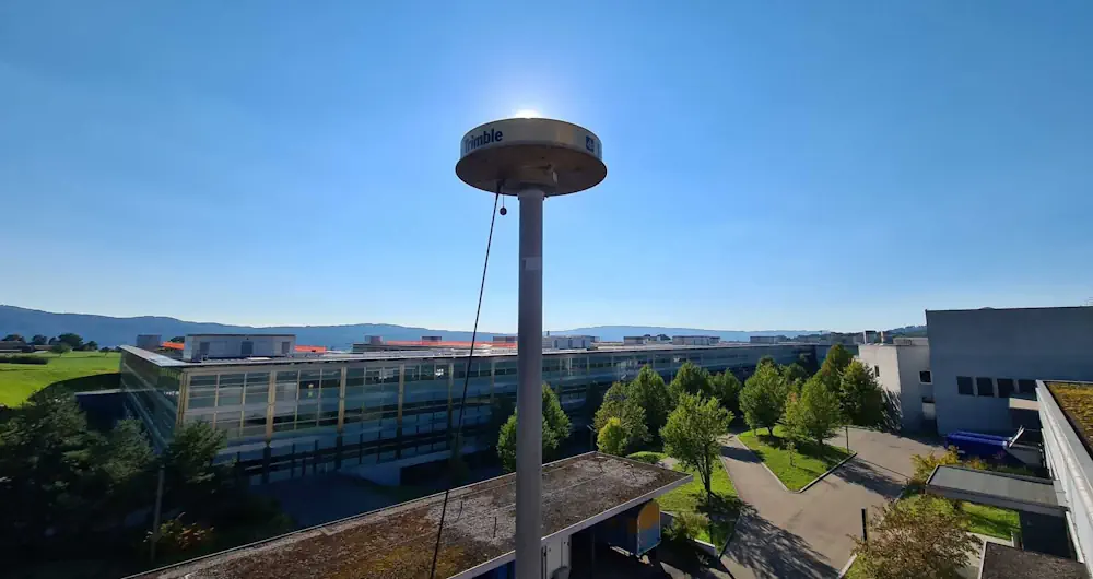
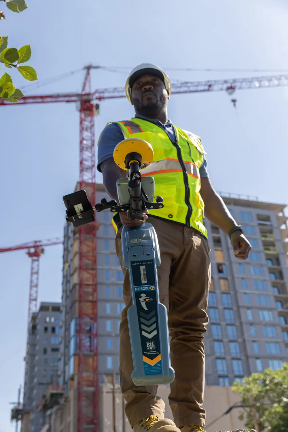
Trimble and Radiodetection announced today a collaboration to improve the technology used in the utility measurement and mapping process. Through the integration of the Trimble® Catalyst™ DA2 GNSS system and Radiodetection’s RD MapTM+ application and precision locator products, the software and hardware integration streamlines utility-locating workflows to provide high-accuracy measurement capabilities for the creation of ...
directionsmag.com

Geospatial Commission Joins UK Centre For Seabed Mapping

The Geospatial Commission had today (Wednesday 20 March) become the 31st member of the UK Centre for Seabed Mapping (UK CSM). The UK CSM, which is administered by the UK Hydrographic Office (UKHO), was created in June 2022 to spearhead a coordinated approach to the collection, management and access of seabed mapping data and to ...
gov.uk
Satellite Data Illuminate Carbon Sequestration Success In Drought-Stricken Southwest China

Satellite Data Illuminate Carbon Sequestration Success In Drought-Stricken Southwest China

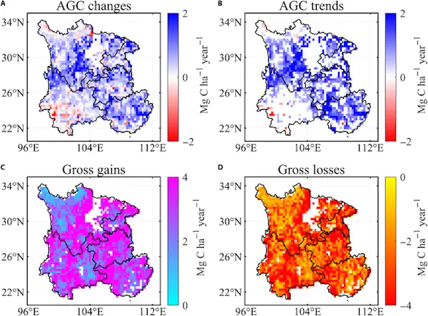
Recent research highlights a significant rise in Southwest China’s aboveground carbon levels between 2013 and 2021, showcasing the area’s capacity to counterbalance the negative impacts of severe droughts. This development emphasizes the vital role of Southwest China as a carbon sink, attributed to substantial ecological efforts and the deployment of cutting-edge remote sensing methodologies. For ...
spacedaily.com
Satellites Track The Tiny Silver Fish Hugely Important To Marine Life

Satellites Track The Tiny Silver Fish Hugely Important To Marine Life

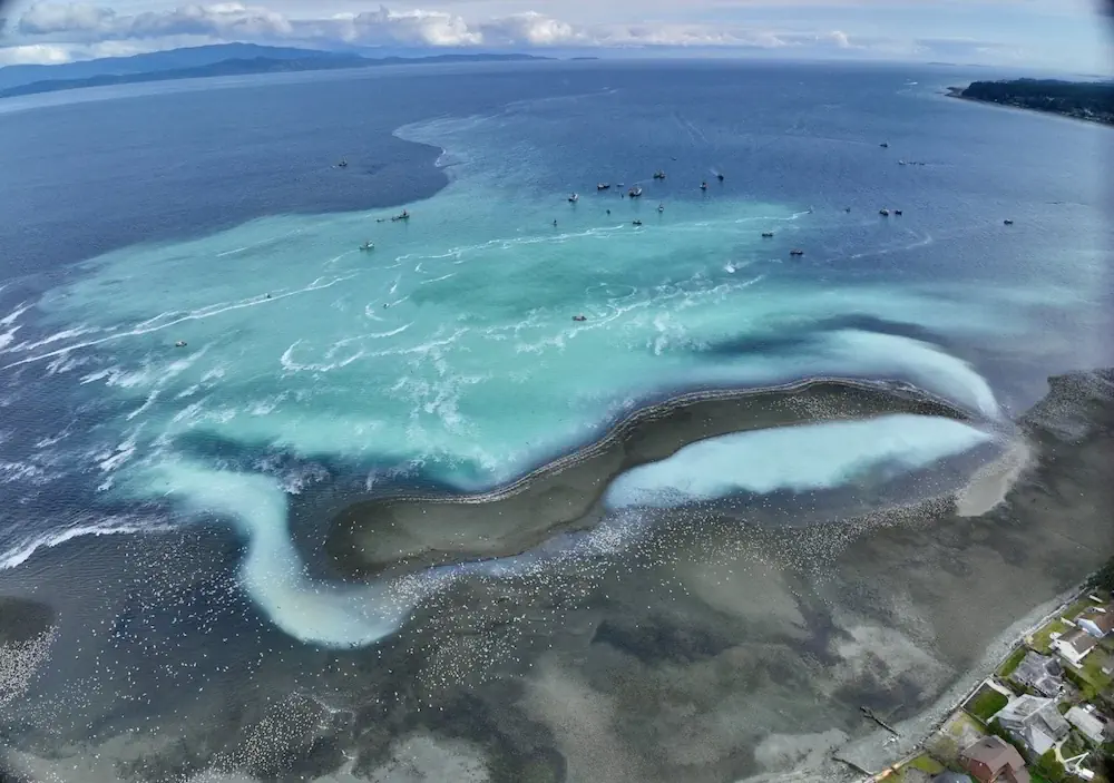
A new scientific endeavour has taken to the sky using high-tech drones and satellite images to understand better the annual spring herring spawn vital to salmon and wildlife on the West Coast. Between February and March each year, frigid ocean waters transform to a milky tropical-looking turquoise green when male herring release milt to fertilize ...
nationalobserver.com
AI And Drones Aid Farmers With Identifying Botrytis

AI And Drones Aid Farmers With Identifying Botrytis

Researchers from Unmanned Valley, Greenport DB, and NL Space Campus in the Netherlands have successfully developed an AI model that enables drones to identify the disease botrytis. The model leverages artificial intelligence to analyze vast amounts of drone data, resulting in a detailed map that pinpoints, with millimeter precision, which plants are diseased or at ...
futurefarming.com

Conferenza Nazionale Di Geomatica E Informazione Geografica #ASITA2024 Primo Annuncio E Call For Abstract

ASITA è il luogo dove professionisti, docenti, ricercatori, tecnici e professionisti, soggetti istituzionali e territoriali, società commerciali e più in generale tutti coloro che operano nei diversi campi della Geomatica possono confrontarsi su temi specifici, promuovendo una visione multidisciplinare e integrata del settore della Geomatica nel tentativo di delineare le cosiddette “best practices” utili ad ...
rivistageomedia.it

Nueva Alianza Entre Organismos Nacionales Para Mejorar La Información Geográfica Marítima Y Terrestre

El Ministerio de Transportes y Movilidad Sostenible ha anunciado la firma de un protocolo con el Ministerio de Defensa, específicamente con la Armada, para fomentar la colaboración entre el Instituto Geográfico Nacional (IGN), su Centro Nacional de Información Geográfica (CNIG) y el Instituto Hidrográfico de la Marina (IHM). Esta alianza estratégica busca compartir y mejorar ...
elestrechodigital.com

Esri Se Asocia A Acutel Para Hacer Accesible Su Tecnología Geoespacial A Los Operadores De Telecomunicaciones Neutros Y Locales

Esri, empresa líder en tecnología geoespacial, ha firmado un acuerdo de colaboración con Acutel, la Asociación Nacional de Operadores de Telecomunicaciones y Televisión Local de España, entidad que aglutina a casi 250 compañías que ofrecen servicios de internet, telefonías fija y móvil y televisión, y cuyo objetivo es que los operadores de telecomunicaciones locales puedan ...
dirigentesdigital.com
Flightradar24’s New GPS Jamming Map

Flightradar24’s New GPS Jamming Map

We’re pleased to release our new GPS jamming map tool. The new map allows users to view areas of GPS jamming and interference around the world in an easy to understand visual format. As part of the ADS-B messages we receive from each aircraft, the Navigation integrity category (NIC) encodes the quality and consistency of ...
flightradar24.com

Saudi Ministry Launches GIS-Enabled Digital Platform For Water Management

The Ministry of Environment, Water, and Agriculture has announced a significant step forward in water management and planning by signing a contract to establish a geographical information system (GIS) for water planning. This initiative aims to create a smart water digital platform aligning with international best practices for the water sector within the Kingdom. Dr. ...
zawya.com

ESA-JRC Opens Registration For GNSS Summer School

The European Space Agency (ESA) and the European Commission’s Joint Research Centre (JRC) are collaborating to host the 15th edition of the International Summer School on Global Navigation Satellite Systems (GNSS). The course is scheduled to take place in Novo Mesto, Slovenia, from July 15 to 26, 2024. The summer school invites graduate students, Ph.D. ...
gpsworld.com

California Is Finally Digitizing Its 100-Year-Old Paper Water Rights

In a Sacramento office building, university students carefully scan pieces of paper that underpin California’s most contentious and valuable water disputes. One by one, they’re bringing pieces of history into the digital era, some a century old and thin as onion skin. The massive undertaking will unmask the notoriously opaque world of California water. Right ...
insider.govtech.com
Romania’s Energy Ministry Makes Map Of EV Charging Points Available

Romania’s Energy Ministry Makes Map Of EV Charging Points Available

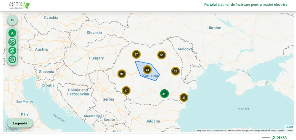
A map with charging points for electric cars was recently unveiled by Romania’s Energy Ministry. The map is featured on the website of the institution, and was made in partnership with local authorities across the country. Romanian energy minister Sebastian Burduja said that the map is part of the EU-wide project of reaching 75 million ...
romania-insider.com