Geomaticians

15

GUGIK Udostępnił Dane Ukośne I Modele 3D Mesh Dla Malborka

GUGIK Udostępnił Dane Ukośne I Modele 3D Mesh Dla Malborka

Do Państwowego Zasobu Geodezyjnego i Kartograficznego przyjęto kolejne wysokorozdzielcze dane fotogrametryczne dla miasta Malbork, opracowane na zlecenie Głównego Geodety Kraju. Dane obejmują: Zdjęcia lotnicze pionowe i ukośne o GSD = 5cm; Ortofotomapę klasyczną i ukośną o terenowym rozmiarze piksela 5 cm; Chmurę punktów o gęstości co najmniej 12 pkt/m2 (PL-EVRF2007-NH); Numeryczny model terenu (NMT) o ...
gisplay.pl
Student Geodezji Na UWM Z Nagrodą Za Badania Nad Jonosferą

Student Geodezji Na UWM Z Nagrodą Za Badania Nad Jonosferą

Nie trzeba wcale lecieć w Kosmos, żeby badać jonosferę. Marek Czołpiński, student z Wydziału Geoinżynierii UWM za badania nad jonosferą otrzymał nagrodę w konkursie organizowanym przez Stowarzyszenie Geodetów Polskich oraz Główny Urząd Geodezji i Kartografii. „Analiza gęstości elektronów na wysokości orbity Swarm w kontekście sejsmicznych zaburzeń jonosferycznych” to tytuł pracy inżynierskiej, za którą Marek Czołpiński ...
uwm.edu.pl
Il «Gemello Digitale» Di Brescia Pronto A Nascere Al Via La Sperimentazione Sulla Linea 3 Del Tram

Il «Gemello Digitale» Di Brescia Pronto A Nascere: Al Via La Sperimentazione Sulla Linea 3 Del Tram

Il gemello digitale di Brescia è pronto a vedere la luce. Entro l’autunno il Comune si doterà infatti dell’infrastruttura di base (il software) che verrà popolata e modellata a seconda delle esigenze che verranno individuate e ritenute importanti. E una sperimentazione è già attiva e fa riferimento al tracciato della ipotetica linea 3 del tram ...
giornaledibrescia.it

I Dati Satellitari Per Il Controllo Del Microclima Urbano. All’oar Il Convegno Con L’agenzia Spaziale Italiana E Il Politecnico Di Milano

Arrivano dai dati satellitari gli strumenti per mappare il fenomeno dell’isola di calore urbana e capire come la struttura fisica della città e l’uso del suolo influiscano sul microclima urbano. Se ne parla al convegno che si terrà venerdì 23 febbraio presso il complesso monumentale dell’Acquario Romano, sede dell’Ordine degli Architetti di Roma e Provincia. ...
architettiroma.it
Prosegue La Mappatura Degli Alberi, Già Censite 3500 Piante 60 Dovranno Essere Abbattute

Prosegue La Mappatura Degli Alberi, Già Censite 3500 Piante: 60 Dovranno Essere Abbattute

Geat, società di gestione servizi per l’ambiente e il territorio, è stata incaricata dal Comune di Riccione di condurre un censimento completo del patrimonio arboreo presente sul territorio comunale. Il progetto, avviato nel 2023, ha l’obiettivo di valutare lo stato di salute e la sicurezza di circa 10.500 alberi, pari a un terzo del totale ...
riminitoday.it

El Estudio Que Revela Posibles Vínculos Entre Incendios Forestales Y Expansión Urbana En Chile

Apartir de la catástrofe sobre los recientes incendios forestales que afectaron a distintos sectores de la Región de Valparaíso, nuevamente se ha puesto la atención sobre la eventual relación que tendrían estos siniestros con el interés inmobiliario por ocupar los espacios que fueron damnificados. En el estudio “Construyendo sobre cenizas. ¿Son utilizados los incendios forestales ...
interferencia.cl
Inertial Labs And E38 Collaborate For Drone-Lidar Integration

Inertial Labs And E38 Collaborate For Drone-Lidar Integration

In a new strategic partnership, Inertial Labs’ RESEPI Payload Lidar technology will be integrated into E38’s advanced E455 drone platform. This collaboration marks a significant milestone in the utilization of uncrewed aerial systems (UAS) for professional surveying, mapping and inspection services. Inertial Labs is recognized for its innovative essential navigation solutions, and E38 Company is ...
gim-international.com
Wingtra Debuts Pioneering Lidar Drone Solution

Wingtra Debuts Pioneering Lidar Drone Solution

Wingtra has unveiled its innovative Lidar-drone solution. The new Lidar payload is designed to seamlessly integrate the efficiency, ease of operation, and high accuracy of the WingtraOne GEN II drones with an advanced Wingtra-engineered Lidar sensor, offering notable advancements in the industry. Wingtra is a prominent player in drone technology. The Swiss-based company’s solution is ...
gim-international.com
Mom Makes Map For Vancouver Baby Changing Tables 'You're Flying Blind When You're A Parent'

Mom Makes Map For Vancouver Baby Changing Tables: ‘You’re Flying Blind When You’re A Parent’

Michelle Cyca has had to change too many diapers on bathroom floors. The mother of two (her youngest is in his peak diaper phase right now), says she finally had enough after having to change her child’s diaper on the concrete floor of an Oak Street deli. So she decided to do something about it. ...
vancouverisawesome.com

PlanetScope Now Accessible Via Google Cloud Marketplace

PlanetScope is now accessible on Google Cloud Marketplace. This availability of Planet’s flagship satellite imaging product contributes to the company’s mission to democratize access to near-daily satellite imagery, enabling organizations to visualize and understand the changes occurring on our planet. For Google Cloud customers, leveraging the power of PlanetScope has never been easier. With just ...
gim-international.com

The Role Of Gulls In Spreading Olive Seeds Across Balearic Islands

The spread of the olive tree throughout the Balearic Islands is more closely linked to the thriving local gull population than previously thought, a new study indicates. Researchers found that these birds significantly contribute to the dispersal of olive seeds, which are found inside the pit, across the Mediterranean archipelago, with some seeds traveling considerable ...
oliveoiltimes.com

Space Companies Want Govt To Implement DPI For Earth Observation

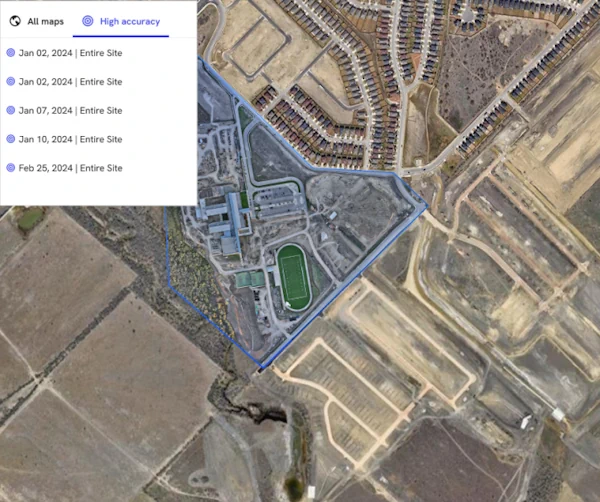
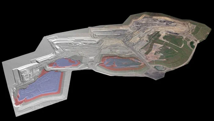
Space startups such as GalaxEye Space, Dhruva Space and Pixxel have called on the government to implement a digital public infrastructure (DPI) for earth observation-based geospatial analytics. The Indian Space Association (ISpA) has sent a representation to the government making a similar pitch, saying it will open new horizons for India’s booming space sector. The ...
economictimes.indiatimes.com
Esri Releases New Landsat Satellite Data App To View And Analyze Land Changes

Esri Releases New Landsat Satellite Data App To View And Analyze Land Changes

Esri, the global leader in mapping and location intelligence, announces the launch of Landsat Explorer, a groundbreaking online app that makes it easier than ever for organizations to access and analyze multispectral imagery from Landsat satellite missions. The new app from Esri’s ArcGIS Living Atlas of the World provides unprecedented ease of use and accessibility ...
businesswire.com
Trimble And DroneDeploy Bring Premier Positioning To UAV Mapping

Trimble And DroneDeploy Bring Premier Positioning To UAV Mapping

Trimble has unveiled the integration of the Trimble Applanix POSPac Cloud post-processed kinematic (PPK) GNSS positioning service, featuring CenterPoint RTX, with the UAV-based mapping and data collection capabilities of DroneDeploy’s reality capture platform. With the Trimble cloud positioning service, DroneDeploy customers can expect centimetre-level accuracy and an automated, streamlined workflow when performing reality capture with ...
gim-international.com
Maptek Introduces Geospatial Manager For Mining Workflow

Maptek Introduces Geospatial Manager For Mining Workflow

At Geo Week 2024 in Denver, Maptek unveiled its latest innovation: Maptek GeoSpatial Manager. This groundbreaking solution simplifies and streamlines workflows, revolutionizing how mining and civil engineering projects manage data from laser scans and drones. Maptek is a leading provider of innovative software, hardware, and services for the mining industry. GeoSpatial Manager effortlessly connects users ...
gim-international.com

برای نخستین بار؛ نقشه پراکنش گونه‌های شاخص حیات‌وحش تهیه می‌شود

حسن اکبری، معاون محیط زیست طبیعی و تنوع زیستی سازمان حفاظت محیط‌زیست گفت: برای نخستین بار نقشه پراکنش ۱۹ گونه جانوری شاخص حیات‌وحش کشور تهیه می‌شود که تاکنون ۵۰ درصد کار پیشرفت داشته است. جغرافیای وسیع و گسترده ایران گونه‌های جانوری زیادی را در خود جای داده است و در هر گوشه و کنار کشور ...
irna.ir
DLR Develops Mobile Station For Satellite Laser Ranging

DLR Develops Mobile Station For Satellite Laser Ranging

Satellite Laser Ranging (SLR) is a very precise, laser-based method for determining the distance between a satellite and Earth with an accuracy of a few millimetres. SLR is primarily used in geodesy. This is because the precise measurement of satellite orbits helps to determine changes in Earth’s structure and rotation. The SLR method also makes ...
spacedaily.com

Geographic Information System To Assess And Mitigate Natural Disasters

Southampton University has partnered with three of Egypt’s top institutions in a project aiming to assess and mitigate natural disasters through geographic information system (GIS) mapping technology. The project, ‘Seismic Resilience of Egypt’s Built Environment: A GIS-Based Framework for Assessment and Mitigation’ (Egypt-SeReAM), has received £133.5K from the Engineering and Physical Sciences Research Council (EPSRC) ...
theengineer.co.uk