Geomaticians

2023

El Metro De Granada Y El Trambahía Recibirán Una Inversión De 2,2 Millones En Transformación Digital Por La Junta

El Metro De Granada Y El Trambahía Recibirán Una Inversión De 2,2 Millones En Transformación Digital Por La Junta

La Consejería de Fomento, Articulación del Territorio y Vivienda invierte 2,2 millones de euros en la implantación de un gemelo digital en el Metro de Granada y en el Trambahía, un novedoso sistema de realidad virtual que permite recrear situaciones que permitan planificar un óptimo mantenimiento de esta infraestructura y mejorar los parámetros de calidad ...
infocostatropical.com

Compulsory For UP Developers To Tag Projects With GIS-based Master Plans

The Uttar Pradesh Real Estate Regulatory Authority (UP RERA) will soon make it mandatory for developers to tag the maps of their projects with the Geographic Information System (GIS)-based master plans in 13 major cities across the state. This move is meant to check whether the upcoming project is on a bona fide site as ...
daijiworld.com
Geospatial Tech Can Help Cities Get Ahead Of Real Estate Speculators

Geospatial Tech Can Help Cities Get Ahead Of Real Estate Speculators

In 2021, investors spent $50 billion purchasing 80,000 homes, accounting for about 18% of all homes sold in the United States that year. And as home prices increase, residential properties grow more attractive to investors who can resell renovated homes for higher prices or charge higher rents. It’s a trend that concerns local leaders nationwide, ...
route-fifty.com

안동시, 국내 석학 초청해 공간정보 발전 포럼 개최

안동시는 지난 29일 국내 공간정보 분야 석학을 초청해 ‘안동시 공간정보 발전 포럼’을 29일 시청 웅부관 청백실에서 개최했다. 시는 최근 국토교통부 ‘디지털 트윈 국토사업’과 국토지리정보원 ‘고정밀 전자지도 챌린저 공모사업’에 선정됐다. 디지털 트윈으로 대표되는 3차원 공간에 안동의 문화유산 콘텐츠와 수자원 인프라 등을 구현해 문화시설과 콘텐츠를 담은 고정밀 전자지도를 구축하고 홍수와 가뭄 등 재해에도 선제적으로 대응하는 다양한 시정 ...
metroseoul.co.kr
El Mapa De Calor Del Ayuntamiento De Madrid Descubre Si Vives En Una Zona Con Temperaturas “Extremadamente Altas”

El Mapa De Calor Del Ayuntamiento De Madrid: Descubre Si Vives En Una Zona Con Temperaturas “Extremadamente Altas”

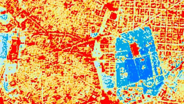
El Ayuntamiento de Madrid ha publicado un mapa en el que cada vecino puede comprobar si vive en un lugar afectado por su isla de calor o, por el contrario, resulta beneficiado gracias a la cercanía de parques como el Retiro, Casa de Campo o espacios de la periferia como Pradolongo, Entrevías o Valdebebas. Estos ...
eldiario.es

Das Geodatenportal Gibt’s Neu Auch In 3D

Das liechtensteinische Geoportal ermöglicht die Suche nach digitalen geographischen Informationen. Es enthält eine Fülle von Informationen übers Land – von sehr spezifischen Fakten wie etwa die Solarengerie-Eignung der Dächer, aber auch allgemeine Basis-Landkarten, raumplanerische Angaben oder Informationen über die Bodennutzung. Wie das Amt für Tiefbau und Geoinformation mitteilt, gibt’s das Ganze jetzt auch dreidimensional. Das ...
vaterland.li

با اتمام مرحله اول طرح «آمایش ملی فضاها، منابع و خدمات کتابخانه‌های عمومی کشور؛ سرور‌های نهاد کتابخانه‌‌های عمومی به نسخه پایه سامانه WebGIS مجهز می‌شود

جلسه ارائه گزارش مرحله اول طرح «آمایش ملی فضاها، منابع و خدمات کتابخانه‌های عمومی کشور در سامانه WebGIS، ۵ شهریورماه ۱۴۰۲ در کتابخانه مرکزی پارک شهر تهران برگزار شد. سید‌عباس رجایی، رئیس مؤسسۀ جغرافیای دانشگاه تهران، اظهار داشت: «فارغ از آمایش و نمایش اطلاعات کتابخانه‌ها بر روی وب، تحلیل‌ها و تعیین محدوده‌های خدمت نیز مطرح ...
ibna.ir
Ejecutivo Destinará Más De 12 Millones De Pesos A Fortalecer Gestión Territorial De Intendencias

Ejecutivo Destinará Más De 12 Millones De Pesos A Fortalecer Gestión Territorial De Intendencias

El ministro de Vivienda y Ordenamiento Territorial (MVOT), Raúl Lozano, suscribió convenios de cooperación financiera y técnica para el desarrollo y planificación territorial de los departamentos de Artigas, Cerro Largo, Durazno, Maldonado, Montevideo, Río Negro, Rivera, Rocha, Salto, Soriano, Tacuarembó y Treinta y Tres. Cada intendencia recibirá 1.100.000 pesos y se prevé ampliar dicho acuerdo ...
gub.uy
Mapping Rivers And Lakes With An Autonomous Watercraft

Mapping Rivers And Lakes With An Autonomous Watercraft

Surveying bodies of water accurately is a challenging task. Authorities and port operators are required to provide up-to-date maps of riverbeds and port facilities. Until now, this has required the use of special mapping vessels and a great deal of manpower. It is costly and is not being carried out with the frequency and precision ...
iosb.fraunhofer.de
New USGS National Map Data Reveals The Potomac River’s Submerged Topography

New USGS National Map Data Reveals The Potomac River’s Submerged Topography

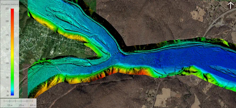
The U.S. Geological Survey recently published a new topobathymetric lidar dataset for the Potomac River as part of its 3D Elevation Program (3DEP). Topobathymetric lidar provides 3D maps of the submerged riverine topography. The maps were produced in two phases for more than 120 river miles of the Potomac River through a data-acquisition contract with ...
marinetechnologynews.com
Satellites Detect Where Locust Infestations Begin

Satellites Detect Where Locust Infestations Begin

Locusts can destroy grain crops and pastures, threatening people’s livelihoods. In an international project, researchers from the German Aerospace Center (Deutsches Zentrum für Luft- und Raumfahrt; DLR) have now developed methods to help detect locust outbreaks as early as possible and take action against them. Earth observation images acquired by satellites play a central role ...
dlr.de
CHCNav Introduces Alphauni 20 Lidar System

CHCNav Introduces Alphauni 20 Lidar System

The AlphaUni 20 (AU20) Lidar system represents a new era in cost-effective, multi-platform mobile mapping solutions, according to CHC Navigation (CHCNav), a global leader in precision mapping, positioning and navigation technologies. Harnessing the power of six years of innovation and product development fuelled by CHCNAV’s Lidar technology, the AU20 is aimed at redefining mobile mapping ...
gim-international.com
PCSDS Upgrades Coastal Mapping Through Google Earth Engine

PCSDS Upgrades Coastal Mapping Through Google Earth Engine

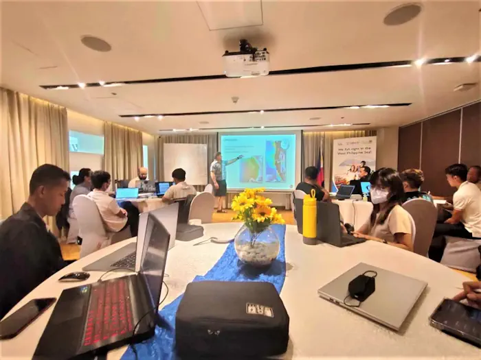
The Palawan Council for Sustainable Development, along with representatives of different government and public organizations dedicated to environmental conservation in Palawan, attended a training-workshop organized by the United States Agency for International Development (USAID) Fish Right program on August 21-23. The workshop consisted of using the features of Google Earth Engine, integrating it with the ...
palawan-news.com
Governo Lança Painel Que Detalha Ocorrências De Desastres Naturais No Rio Grande Do Sul

Governo Lança Painel Que Detalha Ocorrências De Desastres Naturais No Rio Grande Do Sul

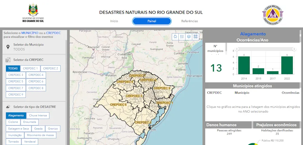
As informações sobre ocorrências de desastres naturais no Rio Grande do Sul entre os anos de 2003 e 2022 foram disponibilizadas pelo governo do Estado em um novo painel, apresentado nesta terça-feira (29/8) durante a 46ª Expointer, em Esteio. No portal, elaborado pela Secretaria de Planejamento, Governança e Gestão (SPGG) em parceria com a Defesa ...
estado.rs.gov.br

Queensland’s Spatial Cadastre Updated For Inland Rail

A two-year project to survey and model nearly 233,000 hectares of land — equivalent to the size of the Australian Capital Territory — to upgrade Queensland’s spatial cadastre, has been completed as a vital part of delivering the Inland Rail project. The spatial cadastre is used to accurately identify the location of the new rail ...
spatialsource.com.au

España Cederá A La UE Imágenes De Su Satélite ‘Espía’

La inteligencia militar española se nutre en buena parte gracias a las imágenes de alta resolución que obtiene a través del Sistema de Observación de la Tierra por Satélite gubernamental con tecnología Radar, más conocido como ‘Satélite PAZ’. España ha decidido ceder gratuitamente a la Unión Europea parte de las imágenes que capten con este ...
cadenaser.com
Esri Canada Launches Assessment Analyst Valueit For Accurate Property Assessment Values

Esri Canada Launches Assessment Analyst Valueit For Accurate Property Assessment Values

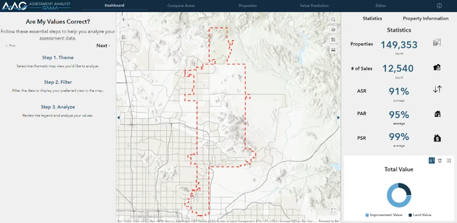
Esri Canada today announced the launch of Assessment Analyst ValueIT, a powerful visualization and analytic application that revolutionizes property assessment by providing clarity and control over the accuracy of assessment values. With AA ValueIT, assessors can confidently determine if assessments meet local or state standards by leveraging the full potential of computer-assisted mass appraisal (CAMA) ...
directionsmag.com

Location Data Can Help Build The EV Chargepoint Network Of Tomorrow

The Geospatial Commission has today (30 August 2023) published a report to support local authorities to make decisions about where to install electric vehicle (EV) chargepoints in their areas. Location data can arm local authorities with evidence to rollout a public charging network that gives current and prospective EV owners the confidence to make their ...
gov.uk
Google Expands Environmental Mapping Tools

Google Expands Environmental Mapping Tools

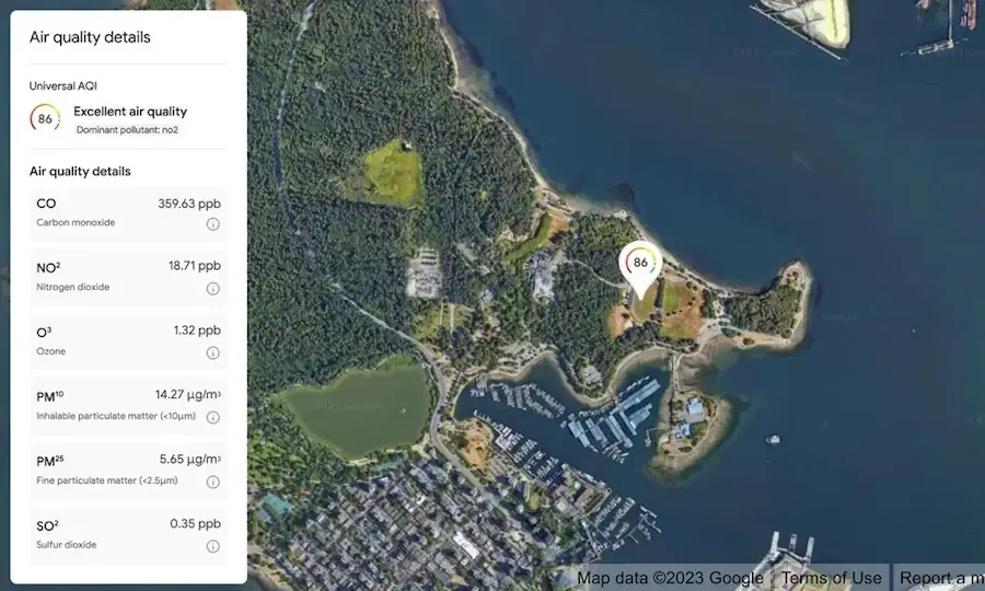
Google is expanding its sustainability offerings with new products from its Google Maps platform, including mapping technologies for solar energy, air quality, and pollen distribution. The mapping tools use AI and machine learning paired with aerial imagery and environmental data to provide valuable information for developers, businesses, and organizations to track and mitigate their environmental ...
environmentalleader.com
EuroGeographics And International Cartographic Association Agree Collaboration To Unlock Power Of Location

EuroGeographics And International Cartographic Association Agree Collaboration To Unlock Power Of Location

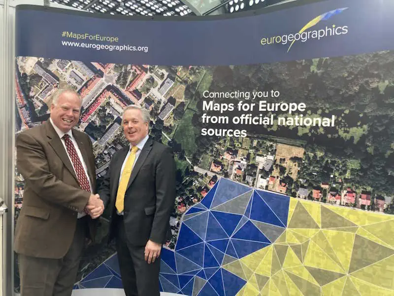
Experts in authoritative geospatial data, cartography and GIScience have today (29 August 2023) announced a new international collaboration to demonstrate the power of location. Members of EuroGeographics, the not-for-profit association for European National Mapping, Cadastral and Land Registration Authorities, and the International Cartographic Association (ICA) will use their collective expertise to support the public good. ...
directionsmag.com

Dry Farm Researchers’ New Mapping Project Will Give Oregon Growers A Resource

As growing seasons become hotter and drier across the region, farmers are increasingly challenged to grow and sustain their crops. Now Oregon State University is close to launching a dry farming map project. Lucas Nebert, a research associate at OSU, heads the project. He told KLCC that a lot of farmers are interested in alternatives ...
opb.org
Alberta Scientists Tracking Blue-green Algae Blooms Using Satellite Imagery_gge

Alberta Scientists Tracking Blue-Green Algae Blooms Using Satellite Imagery

A team of experts is working to better understand the spread of blue-green algae in Alberta lakes by combining satellite technology with near-simultaneous water sampling. The project, funded through Alberta Innovates, is a collaboration between several groups, including Alberta Lake Management Society (ALMS), the Alberta Biodiversity Monitoring Institute (ABMI), and researcher Rolf Vinebrooke from the ...
cbc.ca
TEMPO - Nitrogen Dioxide Air Pollution Over North America

TEMPO – Nitrogen Dioxide Air Pollution Over North America

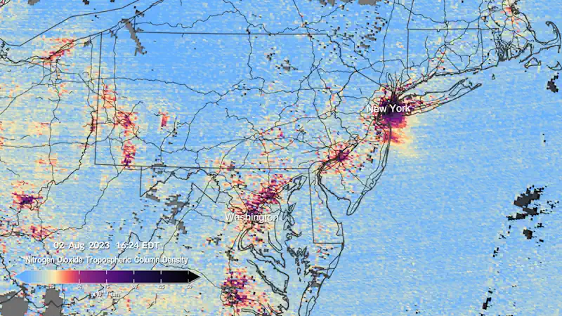
The Tropospheric Emissions: Monitoring of Pollution (TEMPO) instrument collected its “first light” measurements of nitrogen dioxide air pollution over North America on August 2, 2023. Beginning at 11:15 AM Eastern Daylight Time (8:15 AM Pacific Time), the instrument scanned the continent every hour for six consecutive hours. TEMPO measures sunlight reflected and scattered off the ...
svs.gsfc.nasa.gov

CS Launches Online Statistical Data Collection Applications

Chief Secretary of Nagaland, J. Alam, has unveiled two significant online statistical data collection applications developed by the Directorate of Economics & Statistics, Nagaland. The launching programme was held on August 22 at the Chief Secretary’s Conference Hall in Kohima. According to a DIPR report, the first application is the Village Level Development Indicators (VLDI), ...
nagalandpost.com

News Release: Well Sampling Planned In St. Louis County For Groundwater Atlas

The Minnesota Department of Natural Resources will collect water samples from about 180 wells in St. Louis County for use in the development of a Groundwater Atlas of St. Louis County. Selected well owners will be contacted by mail or phone to request permission to sample their wells. The process involves collecting a water sample ...
dnr.state.mn.us

MapBiomas Publica Coleção De Mapas Com 10 Metros De Resolução Espacial

O MapBiomas publicou sua primeira coleção de mapas anuais de cobertura e uso da terra do Brasil feita a partir de imagens de satélite com resolução espacial de 10 metros. A coleção MapBiomas 10 Metros beta produzida com dados dos satélites Sentinel-2 traz os anos de 2016 a 2022 e utiliza um método semelhante e ...
mundogeo.com
Geospatial AI And ML To Revolutionise Air Quality Monitoring In Indian Cities

Geospatial AI And ML To Revolutionise Air Quality Monitoring In Indian Cities

Geospatial artificial intelligence (AI) and machine learning models are set to transform the monitoring of air quality in major Indian cities, including Delhi, Mumbai, Bengaluru, Chennai, and Kolkata. This groundbreaking development was announced by a senior scientist during the India Clean Air Summit (ICAS) 2023. “We must link up SDGs and air pollution indicators, as ...
theweek.in

Gridded Census Data Is Coming, Says Bureau Geographer

In addition to datasets based on mercurial census tracts and census blocks, the U.S. Census Bureau will soon begin publishing datasets in a more reliable gridded format, an agency geographer said during an online event Thursday. Joshua Coutts, a geographer with the bureau’s geography division, told attendees of a National States Geographic Information Council webinar ...
statescoop.com
Some Emperor Penguin Sites Experienced 'Total Breeding Failure' Because Of Sea Ice Loss

Some Emperor Penguin Sites Experienced ‘Total Breeding Failure’ Because Of Sea Ice Loss

Using satellite images, scientists at the British Antarctic Survey were able to see that sea ice in the central and eastern Bellingshausen Sea region last year broke up long before the start of the birds’ fledgling period, when penguin chicks would have developed their waterproof feathers. The research, published Thursday in the journal Communications Earth ...
nbcnews.com
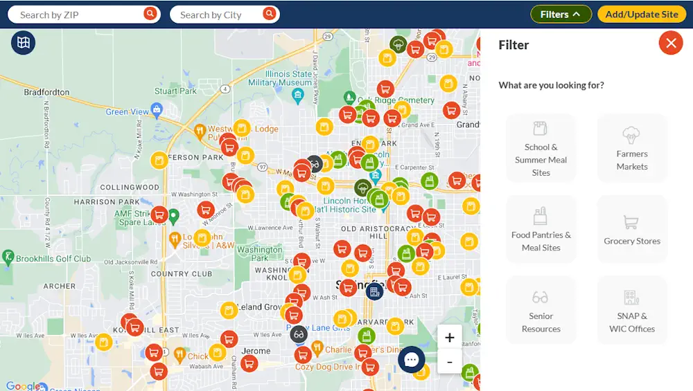
Interactive Map Helps People Find Food And Resources In Illinois

Interactive Map Helps People Find Food And Resources In Illinois

Technology is helping folks with their daily lives find their basic needs. The Find Food IL Map is a digital tool created in response to the COVID-19 pandemic, but it will likely stick around as food insecurity becomes more prevalent. When the pandemic hit, many families found themselves grappling with a new reality – a ...
ksdk.com