Geomaticians

2023

IA Torna Mais Preciso O Mapeamento Da Intensificação Agrícola No Cerrado

IA Torna Mais Preciso O Mapeamento Da Intensificação Agrícola No Cerrado

Metodologia pioneira, desenvolvida com suporte da Inteligência Artificial (IA), permitiu o alcance de um nível de acurácia de até 97%, quando aplicada em análises de imagens de satélite do Cerrado do município de Sorriso (MT), um dos principais produtores agrícolas do País. A acurácia é um aspecto relevante nos levantamentos realizados por meio de sensoriamento ...
mundogeo.com

AWS Ties Up With ISRO And IN-SPACe To Advance India’s Space Capabilities With Cloud Technologies

Amazon Web Services (AWS) India Private Limited has signed a strategic Memorandum of Understanding with the Indian Space Research Organization (ISRO) and Indian National Space Promotion and Authorization Centre (IN-SPACe) to support space-tech innovations through cloud computing. This collaboration will give space startups, research institutes and students access to cutting edge cloud technologies that accelerate ...
aboutamazon.in
Microsoft And Esri To Speed Up Access To Earth-Observation Data

Microsoft And Esri To Speed Up Access To Earth-Observation Data

To speed up access to Earth observation data for millions of customers, Esri is closely integrating its ArcGIS geographic mapping platform with Microsoft Azure Space. “We’re putting the entire technology stack in Azure Space data centers,” Richard Cooke, Esri, imagery and remote sensing director, told SpaceNews at the World Satellite Business Week conference here. “We ...
spacenews.com

Calling On OEMS To Take Part In Survey To Enhance Precise Positioning Through SouthPAN

The Australian and New Zealand governments, with support from FrontierSI, are conducting a survey with Original Equipment Manufacturers (OEMs) to understand the opportunities and barriers for integrating SouthPAN signal support in your GNSS chips, devices and equipment. SouthPAN is the first Satellite-Based Augmentation System (SBAS) in the Southern Hemisphere and provides improved positioning and navigation ...
insidegnss.com

공공데이터포털 전면 개편…246억 원 투입해 융합·분석 플랫폼으로

정부가 공공데이터포털의 데이터 접근성과 활용성을 사용자 중심으로 획기적으로 높이기 위해 본격적으로 전면 개편한다. 지능형 검색과 맞춤형 데이터를 추천하는 공공데이터 융합,분석 플랫폼으로 ‘업그레이드’하고자 오는 2026년까지 246억 원을 투입하기로 한 것이다. 한편 공공데이터포털은 2013년 서비스를 시작해 현재 8만 3000여 개 공공데이터를 개방하고 있는 명실상부 정부 대표 데이터플랫폼이다. 이 플랫폼에서 주요 공공데이터를 개방해 지금까지 공공데이터 민간활용 건수가 5300만 ...
shtimes.kr

German Start-Up And Airbus Defence Space Team Up On Datacubes

German Start-up Rasdaman GmbH and Airbus Defence and Space announce a collaboration towards the next generation of Earth Observation exploitation services, centred around spatio-temporal datacubes, to pave the way for a dynamic version of the CopDEM for analytics in the cloud. “We add new features by the week, inspired by the impressive quality the data ...
geospatialworld.net

جامعة الملك عبدالعزيز تقدّم مشروع “أطلس الوديان في المملكة”

قدّم مركز أبحاث المياه بجامعة الملك عبدالعزيز، مشروعًا جديدًا يُعنى بأطلس الوديان في بعض مناطق المملكة، ضمن مبادراته العملية للحفاظ على الماء بوصفه من أهم الموارد الطبيعية لحياة الإنسان وجميع أنشطته الاجتماعية والاقتصادية في مختلف المجالات، وخاصة في مجال الزراعة والصناعة. تأتي فكرة المشروع مع تزايد النمو السكاني وازدياد استهلاك المياه من مختلف القطاعات التنموية، ...
alyaum.com
Desarrollan Una Plataforma Con Información Espacial Para La Vigilancia De Enfermedades

Desarrollan Una Plataforma Con Información Espacial Para La Vigilancia De Enfermedades

La Comisión Nacional de Actividades Espaciales (CONAE) finalizó el desarrollo de un sistema integrado de vigilancia basado en información espacial para enfermedades transmitidas por vectores, que próximamente estará online para el uso del público en general, gobiernos locales e instituciones de la salud pública. La herramienta fue desarrollada completamente con software libre y de código ...
argentina.gob.ar

Survey And Geospatial Information Authority Releases Official Map Of Saudi Arabia

Saudi Arabia’s General Authority for Survey and Geospatial Information announced on Monday that it is the national authority responsible for producing the official map of the Kingdom with approved international borders. It also said it is responsible for providing maps to all government agencies, the private sector, the academic sector, individuals, and the media, Saudi ...
arabnews.com
Galileo Becomes Faster For Every User

Galileo Becomes Faster For Every User

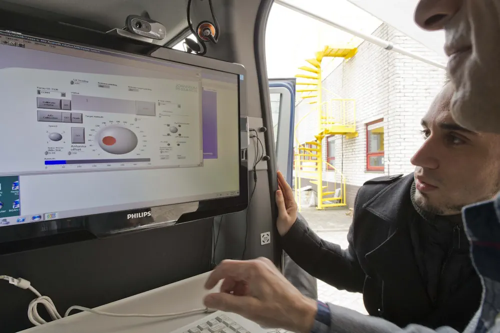
ESA satnav receiver vans – driving between the busy heart of Rotterdam, quiet countryside, and the Agency’s ESTEC technical centre – have confirmed that Galileo signals now provide a first position fix more rapidly, while also offering improved robustness in challenging environments and streamlined access to time information. The improvement comes from a new so-called ...
esa.int

Association For Royal Geographical Society Renew Collaboration

The Association for Geographic Information (AGI), the UK membership organisation for companies and individuals working in the geospatial sector, and the Royal Geographical Society (with the Institute of British Geographers) (RGS-IBG) have signed a new Memorandum of Understanding (MoU). This strategic alliance, in alignment with both organisation’s objectives and strategies, will strengthen communications to maximise ...
directionsmag.com
¿Sabías Que Hay Un Portal Web Con Más De 2.200 Datos Sobre Bogotá Conócelo Aquí

¿Sabías Que Hay Un Portal Web Con Más De 2.200 Datos Sobre Bogotá? Conócelo Aquí

El portal web Datos Abiertos Bogotá es una plataforma digital que reúne un vasto y diverso conjunto de datos geográficos y alfanuméricos que pueden ser útiles para investigadores, docentes, veedores, estudiantes y ciudadanía, interesados en explorar el pulso de la ciudad. El portal alberga una colección de más de 2.200 conjuntos de datos, publicados de ...
bogota.gov.co

Thailand Scheduled To Launch Satellite Into Space In October

Thailand has scheduled the Thailand Earth Observation Satellite 2 (Theos-2) satellite, a primary satellite, to launch into space to carry out its mission of earth observation in October. After it was developed and successfully tested, the Theos-2 satellite has been transferred from Airbus Defence and Space in Toulouse, France, to the European spaceport in French ...
borneobulletin.com.bn
China Launches Classified Yaogan Remote Sensing Satellites

China Launches Classified Yaogan Remote Sensing Satellites

China has added to its growing network of classified Yaogan series satellites with a pair of Long March rocket launches. A Long March 4C lifted off from the Jiuquan Satellite Launch Center in northwest China at 2:14 p.m. EDT on Sept. 7 (1814 GMT, or 02:14 a.m. Beijing time on Sept. 7). Aboard was Yaogan ...
space.com
Open Access To Evidence On Family, Domestic And Sexual Violence

Open Access To Evidence On Family, Domestic And Sexual Violence

From today, anyone around the world will be able to access an Australian-led data initiative aimed at reducing the rates of family, domestic and sexual violence. The Evidence Portal is a new online tool created and maintained by Australia’s National Research Organisation for Women’s Safety (ANROWS), one of the leading research organisations in Australia on ...
ministers.dss.gov.au
Study Reveals Human Destruction Of Global Floodplains

Study Reveals Human Destruction Of Global Floodplains

A University of Texas at Arlington hydrologist’s study in the Nature journal Scientific Data provides the first-ever global estimate of human destruction of natural floodplains. The study can help guide future development in a way that can restore and conserve vital floodplain habitats that are critical to wildlife, water quality and reducing flood risk for ...
eurekalert.org
Track Montgomery County Road Projects With New Interactive Map

Track Montgomery County Road Projects With New Interactive Map

You have a new way to find out about road improvement projects in Montgomery County. A new interactive road improvement map has been launched online. It’s a new digital tool that provides information about recent and upcoming road projects. Using the GIS system, the map allows you to see which roads are set to be ...
waka.com

Lanzan Consulta Ciudadana Para Definir La Primera Política Nacional De Información Geoespacial De Chile

Los datos geoespaciales que levanta la IDE Chile (Infraestructura de Datos Geoespaciales de Chile) desde el Ministerio de Bienes Nacionales, han sido claves para Chile. Dicha información, que ha sido un insumo fundamental para las autoridades, y también para la investigación y el mundo privado, no contaba con una Política Nacional de Información Geoespacial. Hasta ...
latercera.com

First Atlas Of Urban Nighttime Light Remote-Sensing Data Unveiled

The International Research Center of Big Data for Sustainable Development Goals (CBAS) has released the world’s first atlas of urban nighttime light remote-sensing data, providing support for the research on urban sustainable development. The atlas contains 10-meter resolution nighttime light data on 147 cities in 105 countries around the world. The data was captured by ...
english.news.cn

Online Mapping Tool To Identify Policy-Suitable Land For Renewables

Researchers at the University of Strathclyde have created a new geospatial mapping tool that enables developers to identify land for renewable energy development that complies with both policy and technical requirements. Called Geospatial Opportunity Mapping (GOMap), the new tool is built on the available QGIS framework. “External plugins have been developed specifically for QGIS to ...
pv-magazine.com
NASA Researchers Measure Sinking Land In American Samoa

NASA Researchers Measure Sinking Land In American Samoa

On Sept. 29, 2009, an 8.1-magnitude earthquake struck near American Samoa, Samoa, and Tonga, triggering a tsunami that caused human casualties and $200 million in property damage on the islands. The earthquake also exacerbated another problem in American Samoa: subsidence, or the sinking of land. When combined with relative sea level rise, land sinking can ...
phys.org
Kaleiçi’ndeki Haritalandırma Çalışması Tamamlandı Kaynak Kaleiçi’ndeki Haritalandırma Çalışması Tamamlandı

Kaleiçi’ndeki Haritalandırma Çalışması Tamamlandı Kaynak: Kaleiçi’ndeki Haritalandırma Çalışması Tamamlandı

Türkiye’nin ilk sakin şehri Seferihisar’ın, tarihi Kaleiçi bölgesi ile ilgili yapılan haritalandırma çalışması tamamlandı. Kaleiçi’ne gelen ziyaretçiler, giriş noktalarına yerleştirilen haritalar üzerindeki karekodu okutarak, gitmek istedikleri adrese kolaylıkla ulaşabilecekler.Seferihisar Belediyesi, Sığacık’ta bulunan tarihi Kaleiçi bölgesi ile ilgili haritalandırma çalışması yaptı.Her yıl, on binlerce yerli ve yabancı turistin ziyaret ettiği ve araç girişinin olmadığı bölgede, adreslerin ...
turkiyeturizm.com

Le Géoportail De Santé Publique : Un Allié Pour Les Interventions En Santé

Le Géoportail de santé publique du Québec est une plateforme cartographique qui permet de visualiser la variation géographique d’indicateurs de santé et de ses déterminants partout au Québec. La plateforme est accessible à tous les organismes ainsi qu’au grand public. Des indicateurs sont aussi disponibles en lien avec la qualité de l’air et bruit environnemental, ...
cdeacf.ca

Ecuador Crea Su Primer Atlas Geográfico Y Estadístico Ambiental Y De Los Recursos Hídricos

Ecuador presentó su primer Atlas Geográfico y Estadístico Ambiental y de los Recursos Hídricos para facilitar el acceso a información oficial actualizada, validada y confiable sobre el patrimonio natural y los recursos hídricos, informó este viernes el Ministerio del Ambiente, Agua y Transición Ecológica. Esta herramienta de información está dividida en cinco secciones que contienen ...
lavanguardia.com

Iran Prepares New Satellite For Launch

The “Tolu’-3” (Sunrise-3) satellite, manufactured by Iran Electronics Industries, a subsidiary of the Iranian Defense Ministry, was delivered to the Space Organization on Saturday after passing the final tests. The homegrown satellite weighs over 100 kilograms and offers a resolution of 5 meters in panchromatic mode and 10 meters in multispectral mode. Tolu’-3 will be ...
tasnimnews.com

Chicago Uses Tech, Resident Input To Improve Services

The map-based Chicago Recovery Plan was created with feedback from residents. It also allows them to track progress on city projects to create safe neighborhoods and drive equitable economic growth. Launched in May 2023, the tool is “opening the books on neighborhood investments in a simple, accessible digital format,” Chief Technology Officer Nick Lucius said ...
govtech.com

Saint Louis University Receives $1 Million NGA Grant To Establish Midwestern Satellite Calibration Network

Saint Louis University has received a $1 million grant from the National Geospatial-Intelligence Agency (NGA) to create a satellite calibration network to improve the accuracy of satellite observations and the geospatial tools used to monitor global change, infrastructure resilience, and natural disasters such as landslides, volcanic eruptions, and flooding. The project, “Developing global InSAR solutions ...
slu.edu
What Are The Privacy Concerns When Using Satellite Imagery To Solve Crimes

What Are The Privacy Concerns When Using Satellite Imagery To Solve Crimes?

Once the sole domain of meteorologists and geographers, satellite imagery has become an increasingly useful tool for criminal investigations. Law enforcement agencies across the globe have taken advantage of the high-resolution images offered by satellite technology and are using greater quantities of such images than ever before to aid with investigations. In criminal cases where ...
aerotime.aero
AI2 Researchers Introduce Satlas A New AI Platform For Exploring Global Geospatial Data Generated By Artificial Intelligence From Satellite Imagery

AI2 Researchers Introduce Satlas: A New AI Platform For Exploring Global Geospatial Data Generated By Artificial Intelligence From Satellite Imagery

Manual curation of geospatial data, especially in the realm of renewable energy infrastructure and natural resource monitoring, involves a thorough process of aggregating, cleaning, and correcting datasets from various sources, often across multiple countries. This challenge has hindered efforts in emissions reduction, disaster relief, urban planning, and more, where precise geospatial insights are paramount. While ...
marktechpost.com
Giovani Che Non Studiano Né Lavorano Oxfam Lancia Una Mappa Online Delle Opportunità

Giovani Che Non Studiano Né Lavorano: Oxfam Lancia Una Mappa Online Delle Opportunità

In Toscana ancora oggi oltre il 13,8% dei giovani tra i 15 e i 29 anni non studiano e non lavorano, né partecipano ad attività di formazione. Sono i cosiddetti “Neet”, ragazzi e ragazze che rischiano di restare indietro e non riuscire a costruire il proprio futuro a causa principalmente delle tante disuguaglianze territoriali, di ...
gonews.it