Geomaticians

2023

La CONAE Busca Ampliar La Familia SAOCOM

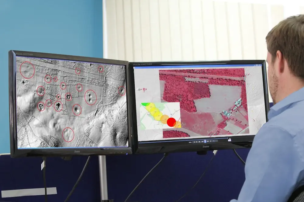
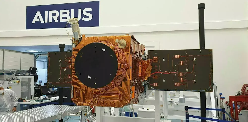
Apoco más de tres años de haber completado la Misión SAOCOM 1, con la puesta en órbita de dos satélites gemelos, únicos en el mundo, la Comisión Nacional de Actividades Espaciales (CONAE) está trabajando en el desarrollo de una nueva generación de satélites con Radar de Apertura Sintética (SAR) en banda L, denominada SAOCOM 2, ...
economicasbariloche.com.ar

L’occupation Des Sols, Thème Central Du Nouvel Atlas Des Cartes De “L’anthropocène” De L’ign

Publiée ce 4 octobre, la deuxième édition de l’atlas “Cartographier l’anthropocène” réalisée par l’Institut national de l’information géographique et forestière (IGN) aborde la question de l’occupation des sols face au changement climatique. Histoire, aménagement du territoire, environnement : la thématique est déclinée sous trois angles. Après une première édition sortie il y a un an, ...
banquedesterritoires.fr

Convenio Entre Mitma Y La Xunta De Galicia Para Obtener Imágenes Aéreas

El Consejo de Ministros ha autorizado la firma de un convenio entre el Ministerio de Transportes, Movilidad y Agenda Urbana (Mitma), a través del Instituto Geográfico Nacional (IGN) y el Organismo Autónomo Centro Nacional de Información Geográfica (CNIG), y la Xunta de Galicia para la obtención de una cobertura completa de imágenes aéreas y ortofotos ...
fly-news.es
Geospatial Data Used To Identify Geohazards For Site Investigations

Geospatial Data Used To Identify Geohazards For Site Investigations

Consultant Card Geotechnics (CGL) has applied aerial laser surveying to pinpoint natural hazards on development sites across the UK. CGL is using geospatial data from aerial survey and geographic data company Bluesky. The data has formed part of the investigation stage on projects ranging from proposed residential developments to long, linear overhead powerlines. High-resolution aerial ...
geplus.co.uk
Google Launches Flood Hub In The U.S., Which Predicts When Rivers Will Flood And Warns People To Evacuate

Google Launches Flood Hub In The U.S., Which Predicts When Rivers Will Flood And Warns People To Evacuate

In August, when heavy rain hit parts of Chile, tens of thousands of people had to evacuate their homes as their communities flooded. Many got a warning a couple of days in advance, thanks to a tool from Google called Flood Hub that rolled out in the country earlier this year. Before Flood Hub existed, ...
fastcompany.com

FAO Broadens Scope Of Innovative Water Monitoring Tool To Include The Whole World

WaPOR, as it is widely known, is expanding its geospatially driven coverage to the whole world, following six years of successful use in Africa and the Near East. The new and improved version was launched today at the Food and Agriculture Organization of the United Nations (FAO) at the 2nd Rome Water Dialogue and on ...
reliefweb.int
Measuring Nutrition In Crops From Space

Measuring Nutrition In Crops From Space

With many people around the world suffering from various forms of malnutrition it’s important that the absolute basics such as rice, soya and wheat are as nourishing as possible. ESA-funded research shows that the Copernicus Sentinel-2 mission and the Italian Prisma mission could be used to monitor the nutritional content of staple crops. This could, ...
esa.int
Tribal Leaders And Researchers Have Mapped The Ancient ‘Lost Suburbs’ Of Los Angeles

Tribal Leaders And Researchers Have Mapped The Ancient ‘Lost Suburbs’ Of Los Angeles

For millions of Los Angeles-area motorists, the Whittier Narrows Recreation Area flashes by in an instant — a tattered oasis of wetlands, sycamore and oak that punctuates the monotonous sprawl of industrial parks, cinder-block sound walls and residential cul-de-sacs along the 60 Freeway and Rosemead Boulevard. But to Andrew Salas, chairman of the Gabrieleño-Kizh tribe, ...
latimes.com
RD Y Cuba Unirán Capacidades Para Desarrollar Atlas De Riesgo Climático

RD Y Cuba Unirán Capacidades Para Desarrollar Atlas De Riesgo Climático

República Dominicana y Cuba exploran vías de intercambio y colaboración para impulsar los Atlas de Riesgo Climático de ambos países, basándose en las capacidades y fortalezas que cada uno de ellos ha desarrollado en materia de observación geoespacial; recolección y sistematización de datos; y desarrollo de las plataformas tecnológicas. “Cuba ha desarrollado y actualiza cada ...
visitantes.do
THEOS-2 Airbus-built Satellite For Thailand Successfully Launched

THEOS-2 Airbus-built Satellite For Thailand Successfully Launched

The Airbus-built THEOS-2 Earth observation satellite has been successfully launched on a Vega rocket from Kourou, Europe’s spaceport in French Guiana. The Geo-Informatics and Space Technology Development Agency of Thailand (GISTDA) selected Airbus as partner for its next-generation national geo-information system in 2018. Jean-Marc Nasr, Head of Space Systems at Airbus, said: “This successful launch ...
airbus.com
Geospatial Analysis Identifies Areas With Individuals Eligible For Lung Cancer Screening

Geospatial Analysis Identifies Areas With Individuals Eligible For Lung Cancer Screening

A model that incorporates demographic and smoking history data has identified regions populated with individuals eligible for lung cancer screening, according to study results presented at the CHEST annual meeting. “Geospatial techniques allow us to look at population-level trends as part of identifying next steps in lung cancer screening outreach and resource planning,” Christine Lambert, ...
healio.com
New AI Algorithm Transforms 2D Photos Into 3D Maps

New AI Algorithm Transforms 2D Photos Into 3D Maps

A new method named MonoXiver uses AI to build up reliable 3D maps of a camera’s surroundings based only on 2D photos. The technology could be especially useful for navigation in self-driving cars. As 2D representations of a 3D world, photos are missing a huge amount of information about the actual sizes of the objects ...
freethink.com

Esri Launches Online GIS Course For Climate Action

As the impacts of climate change increase and intensify around the world, one aspect that has become clear is the geographic nature of the issue. The ability to tackle such a wide-reaching geographic challenge requires technology that gives context, which location intelligence provides. To support the individuals working toward this goal, Esri, the global leader ...
businesswire.com

Powstaje Mapa, Która Pomoże W Bezpiecznym Lataniu Dronami

Od kilkunastu dni, częściej niż zwykle, nad podwarszawskimi gminami można zobaczyć drony. W ten sposób realizowany jest projekt unijny „Usługi cyfrowe dla Bezzałogowych Statków Powietrznych”, w ramach którego powstanie specjalna mapa zwiększająca bezpieczeństwo lotów bezzałogowymi statkami powietrznymi (BSP). Drony tworzą mapę terenu, która w przyszłości pomoże w bezpiecznym poruszaniu się takich urządzeń nad danym terenem. ...
gisplay.pl

La UCLM Y El MNCN Desarrollan Un Método Que Obtiene Mapas Más Fiables Del Riesgo De Las Inundaciones Fluviales

Cuando un río se desborda, inunda los terrenos que lo rodean provocando numerosos daños y situaciones de peligro. La Directiva Europea de Inundaciones regula, entre otras materias, qué se puede cultivar, edificar o programar en las vegas de los ríos con la intención de minimizar los efectos indeseados de un desbordamiento. Un equipo de investigadores ...
lacerca.com
StarNav Receiver Produces Positioning And Timing Results Using Simulated Xona PULSAR Signals

StarNav Receiver Produces Positioning And Timing Results Using Simulated Xona PULSAR Signals

In a recent demonstration, a StarNav receiver yielded 20 cm positioning precision from a cold start using simulated Xona PULSAR signals. StarNav’s receiver tracked up to 13 signals from Xona PULSAR satellites, StarNav CEO Joshua Morales said. The signals were simulated by a Safran simulator. Morales showcased the results at ION GNSS+ in Denver earlier ...
insidegnss.com

In A First, CIDCO To Use AI, Satellite Imagery To Detect Illegal Structures

The City and Industrial Development Corporation (CIDCO for the first time is eyeing the possibility of using automated technology to identify illegal constructions happening in its area. The application that CIDCO plans to develop will enable officials to do extensive area-based study with the help of high resolution satellite imagery. “This technological intervention will supplement ...
hindustantimes.com
HHS Launches Climate And Health Outlook Portal To Identify Counties At Risk Of Climate-related Hazards

HHS Launches Climate And Health Outlook Portal To Identify Counties At Risk Of Climate-related Hazards

Today, in coordination with the White House Summit on Building Climate Resilient Communities, the U.S. Department of Health and Human Services’ (HHS) Office of Climate Change and Health Equity (OCCHE) and Administration for Strategic Preparedness and Response’s (ASPR) Geospatial Team launched the Climate and Health Outlook Portal , an interactive tool that provides actionable, county-level ...
hhs.gov
Ecologists Use Satellite Images To Predict Wheat Yield With 98% Accuracy Via Satellite Imagery

Ecologists Use Satellite Images To Predict Wheat Yield With 98% Accuracy Via Satellite Imagery

RUDN University ecologists found a parameter in satellite images that allows accurately calculating and increasing the wheat yield. Such technology helps agronomists monitor crops and make decisions. These results were published in The Egyptian Journal of Remote Sensing and Space Science. Low crop yields are usually associated with disturbances in agro-climatic conditions, improper or untimely ...
phys.org

Esri España Celebra Su Conferencia Geoespacial Con El Agua Como Temática De Análisis

La Conferencia Esri España, el mayor evento sobre tecnología geoespacial de Europa, organizado anualmente por Esri España, reúne el 4 y 5 de octubre en Ifema (Madrid) algunos de los proyectos más innovadores en la aplicación de tecnología geoespacial en España, entre ellos sobre agua. Bajo el lema ´Creando el mundo que queremos ver´, el ...
tecnoaqua.es

Trimble And Kyivstar Partner To Provide GNSS Correction Services For Agriculture, Construction And Geospatial Applications In Ukraine

Trimble and Kyivstar, Ukraine’s largest telecommunications company, are partnering to install a new Continuously Operating Reference Station (CORS) network to provide Global Navigation Satellite System (GNSS) correction services across the country. Available to users as an annual subscription service, the new network will be built using Trimble’s hardware and software positioning technology, which provides customers ...
agritechtomorrow.com

As Wildfires Worsen, Canada’s Space Agency Wants To Become Firefighters’ Eye In The Sky

Canada’s fire forecasters will be getting a new tool in their battle against out-of-control blazes. In this year’s record-scorching fire season, provincial and federal wildfire agencies had to rely on a mix of European and NASA satellite instruments to help monitor and predict fire behaviour. Now, however, the Canadian Space Agency is preparing to launch ...
cbc.ca

ISRO Working To Expand Navigation System NaVIC Coverage To 3,000 Km From 1,500 Km Beyond India

Isro is working on increasing the coverage of its Indian Regional Navigation Satellite System or NaVIC to 3,000 km from the existing 1,500 km (from beyond the Indian boundary), Isro chairman S Somanath informed on Tuesday. During the CSIR Foundation Day event at Bharat Mandapam, Somanath gave a presentation of the space agency’s activities where ...
timesofindia.indiatimes.com

NWS Unveils New Experimental Flood Inundation Maps For Much Of East Texas, Central Pennsylvania And Parts Of The Northeast

Flooding is the most frequent severe-weather related threat and the costliest natural disaster in the United States. To improve flood warning communication and help emergency managers prepare for and respond to flooding, the National Weather Service (NWS) has begun to add new experimental flood inundation mapping services to its suite of forecast products. These new ...
weather.gov
Photogrammetry App In Major New Release Of Smart Drone Survey Software

Photogrammetry App In Major New Release Of Smart Drone Survey Software

Virtual Surveyor has added drone photogrammetry capabilities to the latest release of its popular Virtual Surveyor smart drone surveying software. The new Terrain Creator app photogrammetrically processes drone photos to generate survey-grade terrains which then transfer seamlessly into the traditional Virtual Surveyor workspace where the real survey work can be performed. “Virtual Surveyor software is ...
amerisurv.com

Cuba Se Apresta A Celebrar La X Convención De Agrimensura 2023

El citadino Hotel Tryp Habana Libre, acoge la X Convención de Agrimensura 2023, cuyas sesiones de debates y feria expositiva se extenderán desde este 25 al 30 de septiembre próximos, informó el Comité Organizador. Antonio Guerrero Rodríguez, presidente de la Unión Nacional de Arquitectos e Ingenieros de la Construcción de Cuba (UNAICC), organizador del encuentro, ...
excelenciascuba.com

Politechnika Lubelska Opracowuje Cyfrowego Bliźniaka Zamościa

Model cyfrowego bliźniaka Zamościa powstaje w ramach międzynarodowego projektu naukowego „Zero energy buildings for zero energy neighbourhoods ZEB4ZEN”. Jego budżet to ponad 2 miliony euro. Głównym celem przedsięwzięcia jest opracowanie ponadnarodowej metodologii i regionalnych planów działania, które pokażą, jak do roku 2050 przekształcić historyczne dzielnice miejskie w dzielnice o niemal zerowym zużyciu energii. „Miasta idealne” ...
geoforum.pl
Presentan Servicio De “Teledetección Con Drones” Para Digitalizar Y Registrar Información Geoespacial Forestal

Presentan Servicio De “Teledetección Con Drones” Para Digitalizar Y Registrar Información Geoespacial Forestal

En la Expoamazónica 2023, el Instituto Tecnológico de la Producción (ITP), a través del CITEforestal Maynas, presentó el servicio de “teledetección con drones”, el cual beneficiará al sector forestal de la región de Loreto. Durante la exhibición que albergó a un gran número de participantes, los especialistas del CITE mostraron como dicha tecnología de vanguardia, ...
agroperu.pe

Emater-MG Usa Imagens De Satélite Para Mapear A Citricultura Em Município Do Sul De Minas

A Empresa de Assistência Técnica e Extensão Rural de Minas Gerais (Emater-MG) está realizando um mapeamento pioneiro das áreas ocupadas com a citricultura em Campanha, no Sul do estado. O trabalho de georreferenciamento, que poderá servir de modelo para outros municípios mineiros, é um cruzamento de diversas informações geradas por satélites, por imagens feitas por ...
agenciaminas.mg.gov.br
PBH Apresenta Base De Dados Urbanos Em Evento Diálogos Urbanos

PBH Apresenta Base De Dados Urbanos Em Evento Diálogos Urbanos

A Prefeitura de Belo Horizonte realizará nesta quarta-feira (27), às 14h, no Teatro Francisco Nunes, o evento Diálogos Urbanos para apresentar as plataformas de dados públicos sobre o planejamento urbano da capital. A intenção é publicizar as ferramentas e permitir a participação da sociedade nas discussões. O evento é destinado a professores, estudantes, pesquisadores e ...
prefeitura.pbh.gov.br