Geomaticians

2023

Áncash Realizan Lanzamiento Del Observatorio Territorial Www.Infogel.Pe

Áncash: Realizan Lanzamiento Del Observatorio Territorial Www.Infogel.Pe

En las instalaciones de la Cámara de Comercio de Áncash, se realizó el lanzamiento del Observatorio Territorial INFOGEL, portal web que permite recopilar, analizar y difundir información relevante a través de datos espaciales, para tener conocimiento de lo que acontece en 20 distritos del área de influencia operativa de Antamina. Instituciones públicas de Áncash y ...
ancashnoticias.com
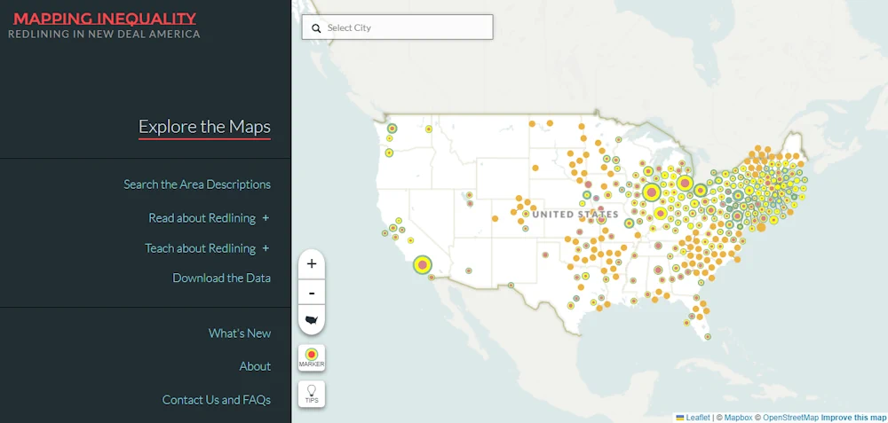
University Of Richmond ‘Mapping Inequality’ Project Releases New Redlining Maps And Other Features

University Of Richmond ‘Mapping Inequality’ Project Releases New Redlining Maps And Other Features

The Digital Scholarship Lab at the University of Richmond has released an updated version of its popular “Mapping Inequality” project. The award-winning, open-access project focuses on redlining — the practice of denying financial services to residents based on race or ethnicity. Mapping Inequality is the largest collection of maps produced by the Home Owners’ Loan ...
news.richmond.edu

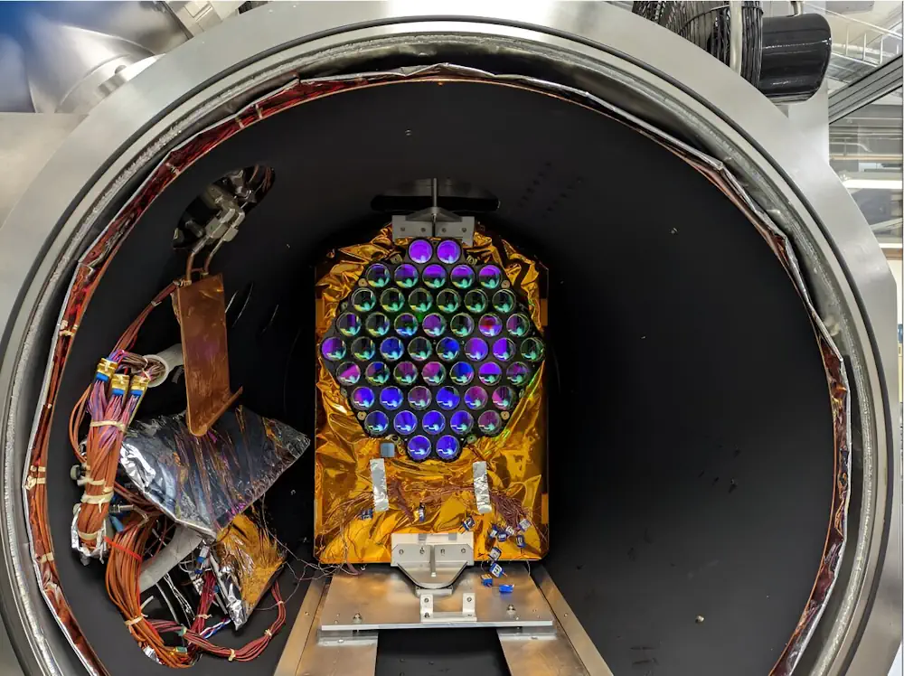
NASA Laser Reflecting Instruments To Help Pinpoint Earth Measurements

The best known use of GPS satellites is to help people know their location whether driving a car, navigating a ship or plane, or trekking across remote territory. Another important, but lesser-known, use is to distribute information to other Earth-viewing satellites to help them pinpoint measurements of our planet. NASA and several other federal agencies, ...
phys.org

Geo-Tagging Of Properties Mandatory To Avail Property Tax Exemption In Delhi: MCD

Municipal Corporation of Delhi has made geo-tagging of all kinds of properties mandatory to avail of the property tax exemption, an official statement said on Tuesday. If any taxpayer fails to geo-tag their properties by 31 January, they will not be able to avail 10 per cent rebate on lump sum advance payment of tax ...
realty.economictimes.indiatimes.com

Rwanda And UAE Sign MoU On Civil Space Activities

UAE and the Rwanda Space Agency have signed a memorandum of understanding with the UAE Space Agency to establish collaboration frameworks in civil space activities, fostering research and development, space technologies, geospatial data sharing, and initiating joint space sector projects. The agreement also offers opportunities for capacity building in space science and technology. This agreement ...
geospatialworld.net
Hastings Introduces Online Snowplow Tracking System

Hastings Introduces Online Snowplow Tracking System

To keep the public up to date on snow removal efforts, the City of Hastings is launching an online snowplow tracking system. The tracking system gives the almost-real time location of city snow-removal vehicles, and identifies with a color coded system where snow-removal vehicles have been. Two years ago, the city implemented AVL (Automatic Vehicle ...
central.newschannelnebraska.com
¿A Qué Huele Málaga Un Proyecto Permitirá Elaborar El Primer Mapa De Olores De La Ciudad

¿A Qué Huele Málaga? Un Proyecto Permitirá Elaborar El Primer Mapa De Olores De La Ciudad

¿A qué huele Málaga? A esta pregunta tratará de responder la Fundación Aula del Mar Mediterráneo (FAMM), que realizará el primer mapa de olores de la ciudad gracias a la colaboración ciudadana y técnicas de ‘big data’, es decir, de macrodatos. La iniciativa se enmarca en el proyecto LifeWatch Eric y en ella pueden participar ...
laopiniondemalaga.es
Visual AI Takes Flight At Canada’s Largest, Busiest Airport

Visual AI Takes Flight At Canada’s Largest, Busiest Airport

Toronto Pearson International Airport, in Ontario, Canada, is the country’s largest and busiest airport, serving some 50 million passengers each year. To enhance traveler experiences, the airport in June deployed the Zensors AI platform, which uses anonymized footage from existing security cameras to generate spatial data that helps optimize operations in real time. Using anonymized ...
blogs.nvidia.com

The Federal Geographic Information Center Launches The General Map Of The UAE

As the official reference for geographic information at the federal level and the authoritative body responsible for issuing official maps, the Federal Geographic Information Center proudly announces the launch of the General Map of the United Arab Emirates in both Arabic and English. This milestone symbolizes a commitment to geographical accuracy and national pride. Part ...
zawya.com

India’s Genesys To Digitally Map Mecca’s Holy City

Genesys International Corporation’s subsidiary in Saudi Arabia, Genesys Middle East Ltd., has been awarded the prestigious contract for the 3D Digital Twin mapping of the Holy City of Mecca by the Kingdom of Saudi Arabia. This pioneering project, valued at Rs. 26 crores in this phase marks a historic venture into utilizing digital twin mapping ...
geospatialworld.net

COP28: NICFI And Bezos Earth Fund To Provide Free Satellite Images

Norway’s International Climate and Forest Initiative (NICFI) and the Bezos Earth Fund announce a new partnership to continue providing the world with free access to high-resolution satellite data to support efforts to stop the destruction of the world’s rainforests. The partnership adds to the USD 43 million previously granted by NICFI to establish the NICFI ...
geospatialworld.net
GSA Created Buzz Around Google's Geospatial Software

GSA Created Buzz Around Google’s Geospatial Software

To inspire artists and creators to learn about and use Google’s new Geospatial Creator in Adobe Aero, Google Arts & Culture partnered with Global Street Art and three reknown artists to bring city streets in London, Mexico City and LA to life. The results picked up the AR/VR Award at The Drum Awards for Out ...
thedrum.com
Hanwha Systems Launches First Privately-Owned Earth Observation Satellite

Hanwha Systems Launches First Privately-Owned Earth Observation Satellite

South Korea’s first privately-owned commercial Earth observation satellite developed with purely Korean technology has successfully launched itself. Hanwha Systems announced that it successfully launched its indigenously developed and manufactured “Small Synthetic Aperture Radar (SAR) Satellite” from the sea south of Jeju Island at 2:00 p.m. on December 4. The launch of the Hanwha Systems “Small ...
koreaittimes.com
China Launches Remote-Sensing Satellite For Egypt

China Launches Remote-Sensing Satellite For Egypt

China launched a remote-sensing satellite for Egypt late on Sunday (Dec. 3) as space cooperation between the two countries deepens. A Long March 2C rocket lifted off from Jiuquan Satellite Launch Center in the Gobi Desert at 11:10 p.m. EST on Sunday (0410 GMT, or 12:10 p.m. Beijing time on Dec. 4), with insulation tiles ...
space.com

New RIEGL UAV-Lidar Scanning Solution Ready For Take-Off

RIEGL has recently added the VUX-18024, a lightweight and versatile UAV-Lidar sensor for high-speed surveying missions, to its portfolio. This once again underlines the Austrian company’s pioneering role as a provider of high-performance Lidar sensors and systems for integration with unmanned aerial systems (UASs). The new RIEGL VUX-18024 offers a wide field of view of ...
gim-international.com

Trimble Supports Indian Institute Of Technology With Inertial Navigation Solutions For UAV Industry Leadership

Trimble announced today a collaboration with the Indian Institute of Technology in Kanpur (IIT Kanpur) to support a new program in uncrewed aerial vehicles (UAV) to be offered by the Department of Aerospace Engineering. A signing ceremony to officially launch the program was held on October 26 and attended by Professor Tarun Gupta, dean of ...
uasweekly.com

IBM Advances Geospatial AI To Address Climate Challenges

IBM today announced new efforts that apply its geospatial AI technologies, including IBM’s geospatial foundation model developed in collaboration with NASA, to climate efforts including analysis of urban heat islands in the United Arab Emirates (UAE); reforestation across Kenya; and climate resiliency in the United Kingdom (UK). IBM continues to advance its AI model strategy ...
newsroom.ibm.com

Datos Satelitales Abiertos Permiten Desarrollar Modelo Que Conecta Polinización Y Terrenos Con Potencial Agrícola

Un innovador estudio que utiliza datos satelitales abiertos ayudará a desarrollar un modelo que integra la presencia de insectos polinizadores y la restauración de predios agrícolas. El estudio es de Laura Pérez, doctora en Ecología y Biología Evolutiva y postdoctorante de Data Observatory, Centro ANID, quien desarrolla hasta el 2025 esta investigación para una mejor ...
diariolagoranco.cl
Satellite Imagery Analysis Firm Launches Free Greenhouse Gas Tracker

Satellite Imagery Analysis Firm Launches Free Greenhouse Gas Tracker

French satellite imagery analysis provider Kayrros launched a free version of its global methane tracking map Nov. 29 to help hold governments and businesses to account for their emissions. The public platform uses data from the European Space Agency’s Sentinel-5P satellite and a sensor on the International Space Station to provide daily snapshots of the ...
spacenews.com
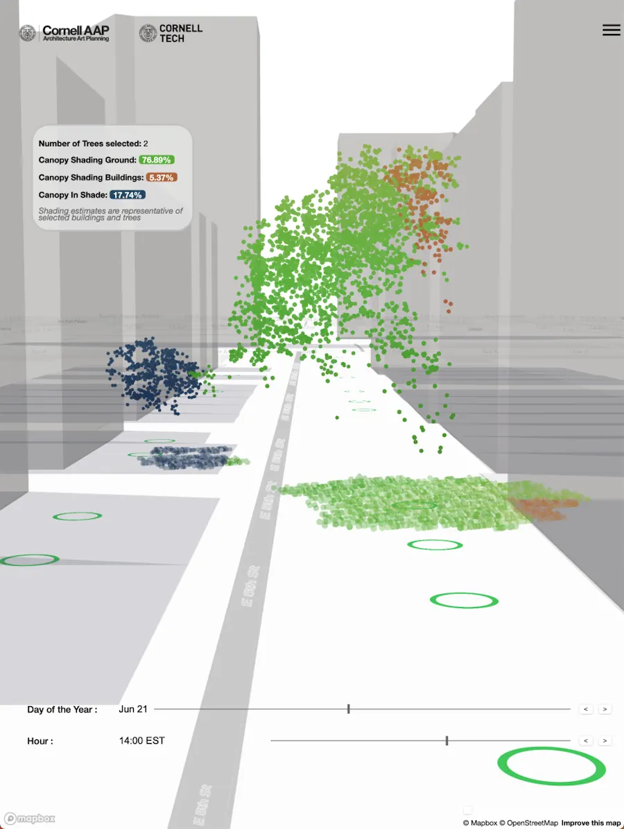
New York Will Plant Thousands Of Trees Using New Tech To Maximize Foliage Impact

New York Will Plant Thousands Of Trees Using New Tech To Maximize Foliage Impact

New York City is poised to get a lot more trees. Last month, the city council passed a measure calling for 30% canopy cover by 2035, up from its current cover of 22% – which could mean 250,000 new trees. More trees, with all their cooling benefits, is a clear win for the environmental justice ...
theguardian.com
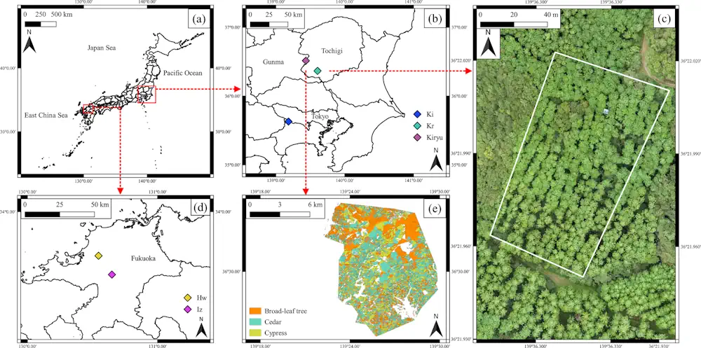
Satellite Remote Sensing Model For Wide-Area Prediction Of Transpiration Rates In Japanese Cypress Plantations

Satellite Remote Sensing Model For Wide-Area Prediction Of Transpiration Rates In Japanese Cypress Plantations

Forests, known as nature’s “green dams,” play a crucial role in replenishing Earth’s groundwater reserves. However, overcrowding in planted forests due to lack of maintenance activities, such as thinning practices, is a pressing concern in Japan. This overcrowding causes substantial water loss from these forests into the atmosphere through a combination of soil evaporation and ...
phys.org
Researchers Propose New Method for Large-Scale Urban Building Function Mapping Using Web-Based Geospatial Data

Researchers Propose New Method for Large-Scale Urban Building Function Mapping Using Web-Based Geospatial Data

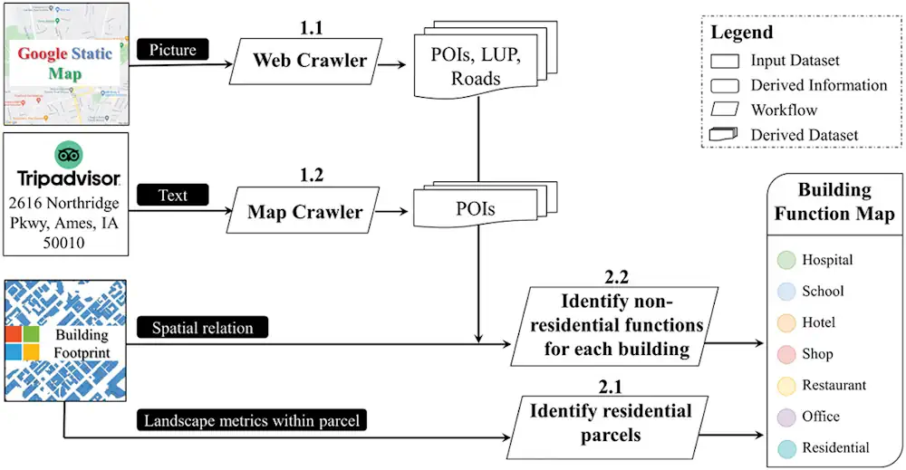
In a pioneering study published in Geo-spatial Information Science, a research group led by Yuyu Zhou from The University of Hong Kong developed an integrated framework that achieves 94% accuracy in mapping building functions across 50 U.S. cities using multi-source web-based geospatial data, offering potential for worldwide application. The team utilized TripAdvisor.com and Google Maps ...
newswise.com

Open Geospatial Consortium Wants Your View On Time

The Open Geospatial Consortium (OGC) is seeking comment on a candidate Abstract Specification Topic, ‘Topic 25 – Abstract Conceptual Model For Time’. The OGC points out that, “Historically, the coordinate systems used in geospatial communities are two- or three-dimensional with temporal aspects stored as attributes of the data rather than valid components of the coordinate ...
spatialsource.com.au
New Heat Map Explores Potential Benefits Of Philly Tree Plan With Block-by-Block Detail

New Heat Map Explores Potential Benefits Of Philly Tree Plan With Block-by-Block Detail

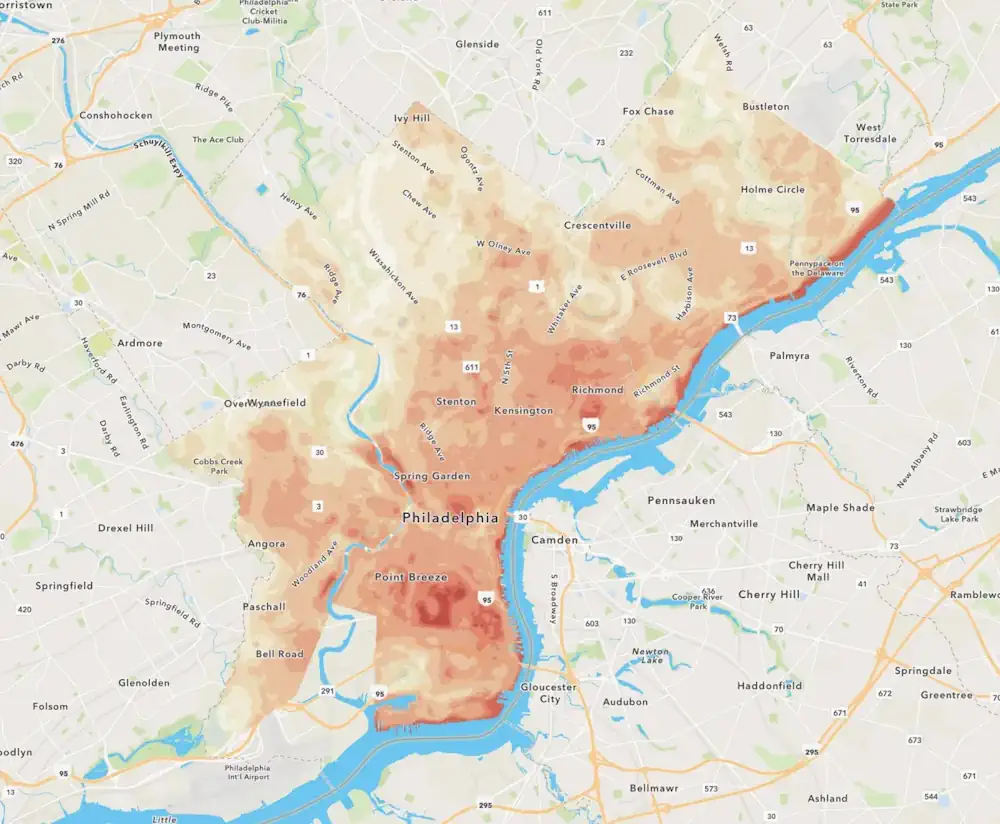
As Philadelphia plants thousands of trees to help cool heat-stricken sections of the city, residents can use a new online tool to see how the decade-long project might help their neighborhoods. You can slide between two overlapping maps of the city: one that reveals how bad the summer heat problem is on a detailed, block-by-block ...
billypenn.com
Près De 60 % Des Bâtiments Cartographiés Dans Le Cadre De La Plus Grande Recherche Canadienne Sur L'accessibilité Ne Sont Pas Accessibles

Près De 60 % Des Bâtiments Cartographiés Dans Le Cadre De La Plus Grande Recherche Canadienne Sur L’accessibilité Ne Sont Pas Accessibles

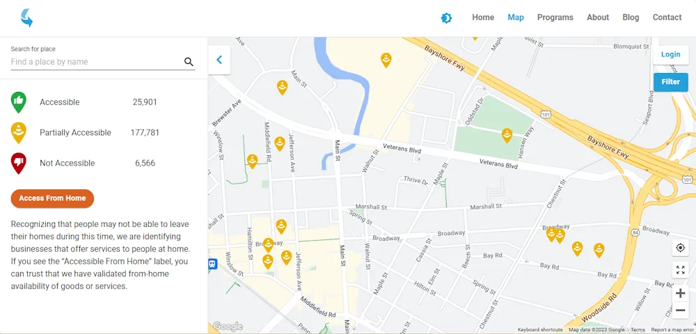
Une nouvelle recherche publiée aujourd’hui par AccessNow, une entreprise de technologie de l’accessibilité, en collaboration avec l’Université de Calgary, Lésions médullaires Canada et BDO, révèle que près de 60 % des bâtiments cartographiés à Vancouver, Calgary et Ottawa ne sont pas entièrement accessibles et met en évidence les zones où les villes et les propriétaires ...
ecranmobile.fr

New Flood Evacuation Tool Helps With Preparedness, Evacuation And Response

Four Clemson University researchers are part of a national team that has developed a Flood Evacuation Tool to help forecast floods, identify at-risk roads and verify safe evacuation routes. The tool partners artificial intelligence (AI) with human knowledge. Researchers are using this human-AI teaming (HAT) partnership to create an intelligent model for addressing flood evacuation ...
news.clemson.edu

Sino-Kenyan Forum Opens In Kenya To Boost Use Of Geospatial Technologies

A Sino-Kenyan forum started in the Kenyan capital, Nairobi, Wednesday to seek ways of promoting the use of geospatial technologies in agriculture, urban planning and natural resource management. The 2023 Supermap GIS software innovation conference that was jointly organized by Kenya’s Directorate of Resource Surveys and Remote Sensing and Chinese firm Supermap gathered government officials, ...
china.org.cn

UAE Launches Development Phase Of Sirb Satellite Programme

The project will enable partnerships with global institutions and offer incentives, as an extension of the Space Economic Zones project. The Sirb programme will enable the commercialisation of satellites and the data they generate on both national and international fronts. This milestone project will include three synthetic aperture radar (SAR) satellites that use advanced imaging ...
gulfbusiness.com

سومین نمایشگاه بین المللی «ایران ژئو» دی‌ماه برگزار می‌شود

این نمایشگاه با هدف ارتقای سطح فناوری و توسعه کسب و کارهای حوزه ژئوماتیک و همچنین ژئوانفورماتیک جمهوری اسلامی ایران هم در داخل و هم در گسترش صادرات خدمات فنی و مهندسی با استفاده از هم افزایی و به کارگیری حداکثر ظرفیت قابل دسترسی بین بخشی برپا شده است. رییس سازمان جغرافیایی خاطرنشان کرد: این ...
irna.ir

China’s GPS-Like Beidou Navigation System Recognised As Global Standard For Commercial Aviation In ‘Important Milestone’

China’s equivalent to the US’ Global Positioning System (GPS) has gained an international qualification that allows it to expand into global commercial aviation, with the “important milestone” a potential boost for the technology, analysts said. The home-grown BeiDou system has been recognised by the International Civil Aviation Organisation as one of its standards, becoming a ...
scmp.com