Geomaticians

2023

Korea To Begin Digital Management Of Roads, Infrastructure Renovation

Road maintenance and infrastructure renovation will be digitally managed and mediated by artificial intelligence (AI) and digital twin technologies to improve the accuracy of natural disaster predictability, the land ministry said, Friday. The Ministry of Land, Infrastructure and Transport said it signed a memorandum of understanding (MOU) with Gyeonggi Provincial Government and Gwangju Metropolitan City ...
koreatimes.co.kr

Saudi Transport Ministry, GASGI Form Partnership To Raise Geospatial Efficiency

In a joint effort aimed at enhancing the performance of the geospatial sector in Saudi Arabia, the Ministry of Transport and Logistic Services signed a partnership agreement with the General Authority for Survey and Geospatial Information to provide reliable geography and mapping information. The agreement, signed at the ministry’s headquarters in Riyadh, aims to raise ...
arabnews.com

Côte D’Ivoire Is Launching Its First Satellite For Earth Observation – And It’s Locally Made

Côte d’Ivoire has announced plans to launch its first satellite within the next two years. A team of scientists in the fields of astrophysics and geology tell The Conversation Africa about the potential benefits of this development and how the country plans to realise its space industry ambitions. YAM-SAT-CI 01 will be a nanosatellite for ...
theconversation.com

Evaluating Measurement Error In Remote-Sensing Deforestation Data

Remote sensing methods are transformative tools used to study deforestation, but they are by no means perfect. In the new paper “Remotely Incorrect? Accounting for Nonclassical Measurement Error in Satellite Data on Deforestation,” published in the Journal of the Association of Environmental and Resource Economists, authors Jennifer Alix-Garcia and Daniel L. Millimet discuss how errors ...
eurekalert.org
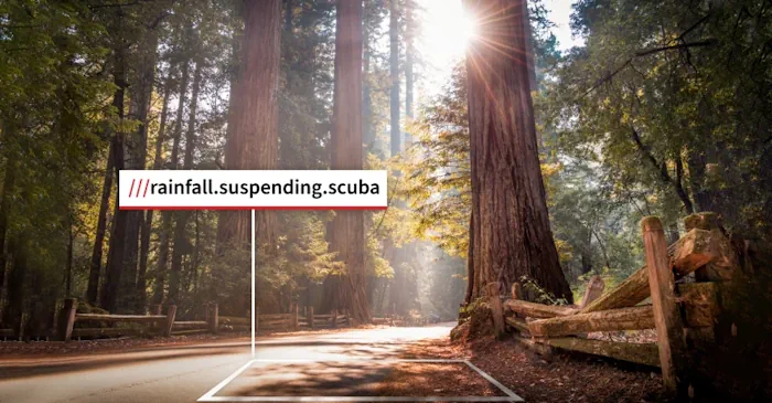
California State Parks Gets New Navigation Technology

California State Parks Gets New Navigation Technology

Last Week, The California State Parks System (CSP) Announced The Addition Of Location Technology To Improve Rescue Operations And The Park Visitor Experience. In Recent Years, New Technologies Like Drones And Robots Are Being Used In Places Like Travis County, Texas, To Improve Search And Rescue Operations. The Location Technology From What3words Has Been Implemented ...
govtech.com
'Underground Climate Change' Threatens To Destabilize Buildings

‘Underground Climate Change’ Threatens To Destabilize Buildings

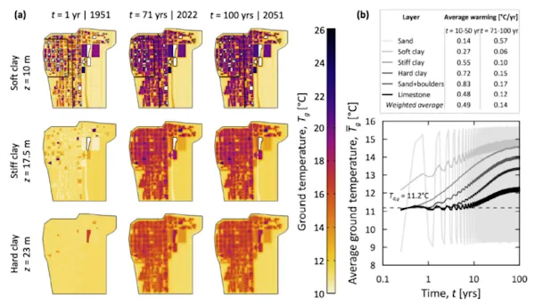
The earth beneath our major cities is heating up, morphing in ways that could damage buildings, bridges, and transport systems. Just ask any passenger sweltering on the London Underground or New York City subway, and they’ll perspire telling you about how underground transport systems are spewing heat. As that heat diffuses into the ground, it’s ...
sciencealert.com
On The Trail Of Landslides And Rockfalls Graz University Of Technology Measurement Method Uses Existing Fibre Optic Lines

On The Trail Of Landslides And Rockfalls: Graz University Of Technology Measurement Method Uses Existing Fibre Optic Lines

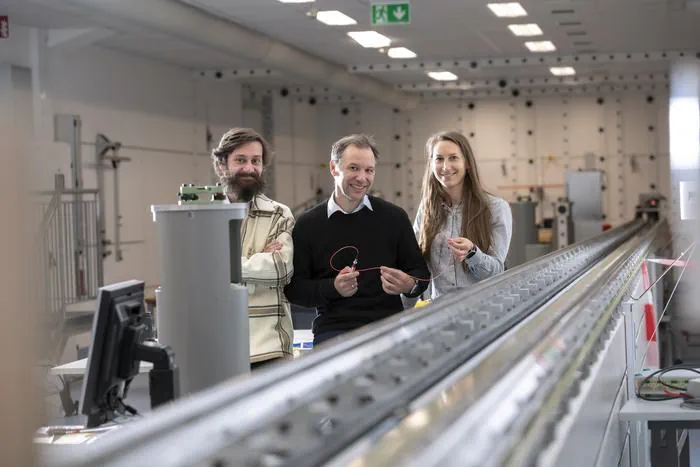
Landslides and rockfalls are increasingly becoming a real threat to people and infrastructure in light of the changing climate and the associated changes in soil and rock structure. The more precise the measurement, the earlier hazards can be detected, and consequently damage can be limited or even avoided altogether. A team at the Institute of ...
tugraz.at

Archeologia Italiana A Portata Di Click: Il Nuovo Geoportale Nazionale Svela I Segreti Del Nostro Patrimonio Storico

Il Geoportale Nazionale per l’Archeologia (GNA) è un punto di raccolta e di condivisione dei dati esito delle indagini archeologiche condotte sul territorio italiano, realizzato grazie alla collaborazione delle soprintendenze e degli archeologi, di altri enti e liberi professionisti. Si tratta di una mappa archeologica dinamica del territorio nazionale, di accesso libero e di facile ...
scintilena.com

New Trimble Terra Office Workflow Delivers Integration With Esri ArcGIS Pro

Trimble announced today the release of the Trimble® Terra™ Office add-in for Esri ArcGIS Pro. The add-in is a new product in Trimble’s Terra Office suite of desktop solutions for integrating Trimble TerraFlex® field data collection software with GIS systems of record. With a streamlined user interface, the new Terra Office add-in for ArcGIS Pro ...
directionsmag.com

Maxar Previews Its New Maxar® Geospatial Platform At Esri UC

Maxar Technologies, provider of comprehensive space solutions and secure, precise, geospatial intelligence, today announced the initial release of its new Maxar Geospatial Platform (MGP), enabling fast and easy access to the world’s most advanced Earth intelligence. MGP will simplify the discovery, purchasing and integration of geospatial data and analytics. MGP users will have access to ...
spaceref.com
Así Puedes Personalizar Los Mapas Cartográficos De Madrid Para Planificar Una Escapada Al Aire Libre

Así Puedes Personalizar Los Mapas Cartográficos De Madrid Para Planificar Una Escapada Al Aire Libre

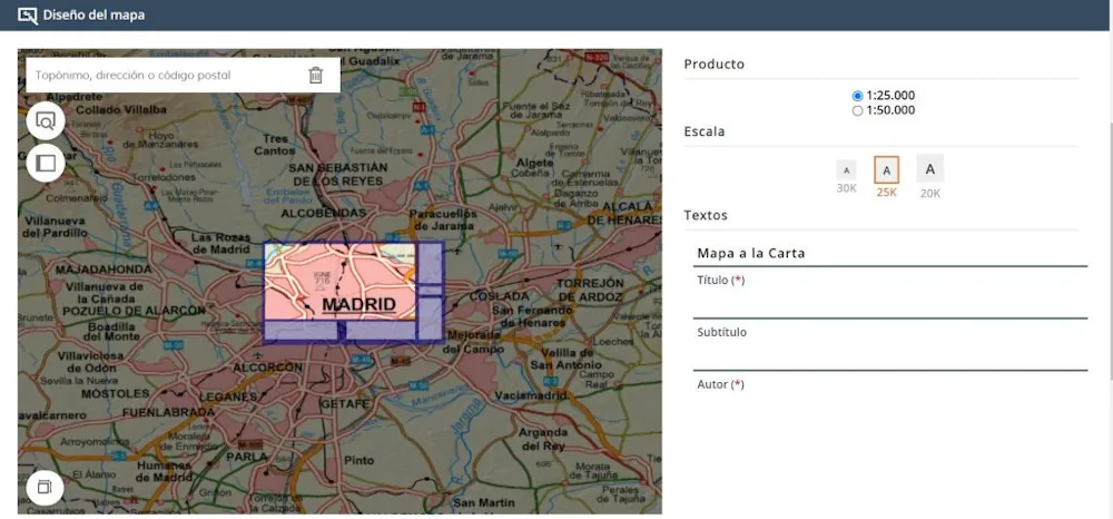
Con la llegada del verano y las vacaciones las ganas de descubrir nuevas rutas de senderismo, bicicleta o, en definitiva, para practicar cualquier disciplina deportiva al aire libre aumentan, con una Comunidad de Madrid en la que hay infinidad de rincones que son desconocidos… hasta ahora. Porque con el «Mapa a la Carta» del Ministerio ...
madridesnoticia.es
NETL CO2-locate Database To Enhance Carbon Capture And Storage Projects

NETL CO2-locate Database To Enhance Carbon Capture And Storage Projects

Creating a net-zero carbon emissions power sector and economy is an immense endeavor that requires a host of intricate technologies and applications, and the CO2-Locate database is a centralized platform that allows users to quickly and accurately obtain the data they need. Now published on the Energy Data eXchange® (EDX), CO2-Locate is one of several ...
netl.doe.gov

NSW To Build Out Digital Twin Features

New South Wales’ digital twin will undergo extensive work over the next 12 months to bring to life its next set of features, with the state government to enlist the help of a third-party delivery partner to build out the platform. But with funding provided by the former Coalition government to deliver a 4D model ...
innovationaus.com

L’observatoire Des Forêts Françaises Est Lancé

Le ministre de l’Agriculture Marc Fesneau et le ministre de la Transition écologique Christophe Béchu lancent l’Observatoire des forêts françaises, afin de rassembler et proposer en un lieu unique les informations indispensables au pilotage des forêts. Cet observatoire a « pour vocation de constituer un centre de partage et de production de données indispensables pour ...
lafranceagricole.fr

Sri Lanka To Cooperate With Foreign Company For Real-time Satellite Imagery On Oil Spills

Sri Lanka’s cabinet has approved a proposal to sign a memorandum of understanding with a foreign company for real-time satellite imagery on oil spills, an official told reporters on Tuesday. Cabinet spokesman Bandula Gunawardena said the number of ships operating in Sri Lankan territorial waters is increasing due to the growth of shipping and port ...
english.news.cn
Huawei Has Filed A Patent To Include Cameras Inside Their Future Earwear As A Pedestrian Safety Feature

Huawei Has Filed A Patent To Include Cameras Inside Their Future Earwear As A Pedestrian Safety Feature

Over the years there have been many headlines regarding teens having been killed, maimed or severely injured due to wearing earbuds and not paying attention to their surroundings, especially near crosswalks. One report pointed to the Toronto Police mentioning Apple’s AirPods as a problem, though it’s more of generic earphones issue in general. The issue ...
patentlyapple.com

Open-Source Online Tool To Optimize Wind-Solar Projects

Scientists At The University Of Murcia Have Developed Climax, An Open-source Tool That Uses The Synergy Between Wind And PV To Reduce The Variability Of Their Combined Production. Climax Identifies Regions With Consistent Temporal Resource Variability And Determines The Optimal Allocation Of Each Technology In Those Regions. The researchers have developed an approach that goes ...
pv-magazine.com
Oregon Beginning Work On Revised 'Wildfire Hazard' Map

Oregon Beginning Work On Revised ‘Wildfire Hazard’ Map

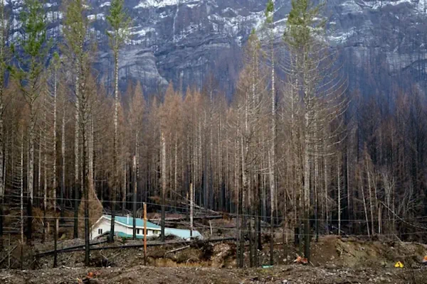
What was called the ‘wildfire risk map’ is now the ‘wildfire hazard map.’ The map is intended to educate homeowners about their exposure to wildfire risk, determine where fire mitigation resources should be prioritized and identify where future state rules on home hardening and defensible space will apply. The name change reflects a shift by ...
ijpr.org
State-owned Aerospace Giant To Build 300-Satellite Constellation At Very Low Earth Orbit By 2030 For Better, More Economic Remote Sensing Services

State-owned Aerospace Giant To Build 300-Satellite Constellation At Very Low Earth Orbit By 2030 For Better, More Economic Remote Sensing Services

China Unveiled Plans To Build A New Satellite Constellation At The Very Low Earth Orbit (VLEO) That Would Comprise 300 Satellites Orbiting The Globe By 2030 And Provide Ultra-fast Remote Sensing And Communication Services, With The First Satellite To Be Launched December This Year , The Global Times Learned From Developers On Wednesday. The Second ...
globaltimes.cn
Thermal Imagery Sector Heats Up

Thermal Imagery Sector Heats Up

British investment firm Seraphim Space surveyed the Earth observation sector a few years ago, categorizing startups by sensor type. Analysts determined that firms focused on electro-optical and synthetic aperture radar were advancing rapidly. Thermal imagery startups were not. “Much to our surprise, it was the only sensor area that didn’t have any companies that had ...
spacenews.com

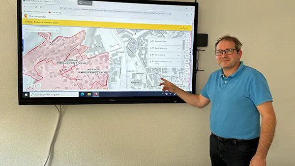
Geoinformationen Für Stadtkreis Baden-baden Öffentlich Zugänglich – Fachbereichsleiter Stefan Hetzel Präsentiert Neues Portal

Die Web-Anwendung wartet jetzt mit einer Reihe neuer Funktionen auf und bietet noch mehr Möglichkeiten, verschiedenste geografische Daten interaktiv zu entdecken. Mit dem neuen Portal bieten wir weitere Möglichkeiten und das nicht nur für Fachleute, sondern auch für die breite Öffentlichkeit», so Hetzel weiter. Das Geoportal wurde 2017 mit dem Ziel ins Leben gerufen, Geoinformationen ...
goodnews4.de
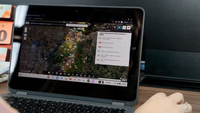
GeoSuzano Oferece Novas Camadas De Funcionalidades

GeoSuzano Oferece Novas Camadas De Funcionalidades

O portal de georreferenciamento de informações GeoSuzano, executado pela Prefeitura de Suzano por meio da Secretaria Municipal de Planejamento Urbano e Habitação, passa a oferecer novas funcionalidades a fim de contemplar o Plano Municipal de Conservação e Recuperação da Mata Atlântica (PMMA). Essa é a quinta atualização da ferramenta, que visa a democratização dos dados ...
suzano.sp.gov.br
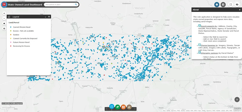
Tennessee Department Of General Services Launches New GIS Map To Display State-owned Land

Tennessee Department Of General Services Launches New GIS Map To Display State-owned Land

The Tennessee Department of General Services is pleased to announce the launch of the new State-Owned Land Dashboard, a Geographic Information System (GIS) public-facing map displaying all the land the state owns. The map gives users access to a comprehensive list of state-owned properties with numerous data points for each property, including address, District, State ...
clarksvilleonline.com

UNBC Research Project To Examine How Mountain Communities Can Better Prepare For Geohazards

If you live in a community in the mountains like Valemount, McBride or Dunster, you are more than aware that rockfalls, landslides, mudslides and floods are facts of life, and as climate change is making those events more common, a new UNBC research project is looking at how mountain communities can better prepare for these ...
ckpgtoday.ca
EUSI Invests In Ground Station Upgrade At The German Aerospace Center (DLR) For The Fastest VHR Satellite Imagery Delivery In Europe

EUSI Invests In Ground Station Upgrade At The German Aerospace Center (DLR) For The Fastest VHR Satellite Imagery Delivery In Europe

European Space Imaging (EUSI), the leading provider of Very High Resolution (VHR) satellite imagery in Europe, is thrilled to announce a multi-million euro investment into their ground station located at the German Aerospace Center (DLR) near Munich. This strategic upgrade extends the ability for EUSI to deliver imagery with unprecedented speed and efficiency, solidifying its ...
directionsmag.com
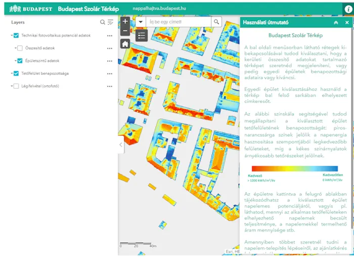
Mapping The Solar Transformation In Budapest

Mapping The Solar Transformation In Budapest

The city’s municipality has created an online solar map which provides the first ever estimation of the solar possibilities for every rooftop in Budapest. Using the solar map as its first step, the ultimate goal of the project is to increase the use of solar energy across the city, leading to greater production of clean ...
eurocities.eu
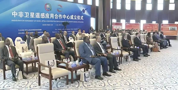
The China-Africa Cooperation Centre On Satellite Remote Sensing Application Takes Off

The China-Africa Cooperation Centre On Satellite Remote Sensing Application Takes Off

Today, the Ministry of Natural Resources (MNR) of the People’s Republic of China welcomed African delegates to inaugurate the China-Africa Cooperation Centre on Satellite Remote Sensing Application. This momentous occasion marked a significant step forward in the collaboration between China and Africa in utilising remote sensing technologies for the sustainable development of natural resources. The ...
africanews.space

New Study Finds Gaps In Maternal Immunization Data Sets

A study led by a University of Canterbury geospatial and population health expert has uncovered gaps in nationwide data that tracks maternal immunization rates. The study has been published in the New Zealand Medical Journal. Health Senior Lecturer Dr. Matt Hobbs is also co-director of the GeoHealth Laboratory in the University of Canterbury (UC) Geospatial ...
medicalxpress.com
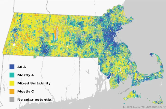
A New State Study Shows Where Solar Is Most Suitable In Mass. — Including Your Home

A New State Study Shows Where Solar Is Most Suitable In Mass. — Including Your Home

For Massachusetts to meet it ambitious clean energy goals, the state needs to build between 25 and 35 gigawatts of solar capacity by 2050. Currently, there are about 3 gigawatts installed — so it’s a tall order. But according to a new study from the state’s Department of Energy Resources, there’s more than enough suitable ...
wbur.org

Le Symposium De Mi-parcours Sera Organisé À Belém, Du 4 Au 8 Novembre 2024

Dans le cadre de la présidence franco-brésilienne 2022-2026 de la Commission III « Remote Sensing » de la Société Internationale de Photogrammétrie et de Télédétection (ISPRS), le symposium de mi-parcours, en partenariat avec le SFPT (France), sera organisé à Belém, du 4 au 8 novembre 2024, ainsi que le symposium latino-américain sur la télédétection SELPER. ...
ird.fr