Geomaticians

September

Using Satellite Data To Enhance Global Food Security

Using Satellite Data To Enhance Global Food Security

Real-time crop monitoring has become increasingly important, particularly for addressing climate-induced losses and damages, as discussed during the last United Nations Framework Convention on Climate Change (UNFCCC) Conference of the Parties (CoP27). Initiatives like GEOGLAM and the Agricultural Market Information System (AMIS) have traditionally contributed to monitoring global food security by relying on existing data ...
phys.org
Nowa Strona Internetowa Serwisu Geoportal.Gov

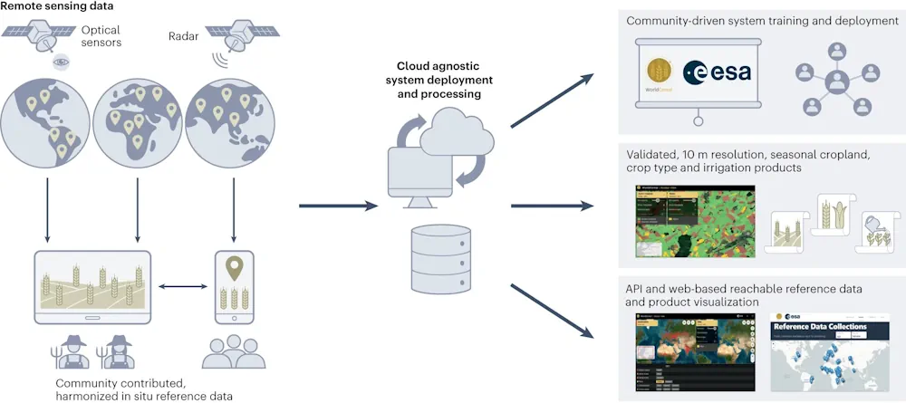
Nowa Strona Internetowa Serwisu Geoportal.Gov.Pl

Jak podkreśla GUGiK, nowa odsłona strony www.geoportal.gov.pl, która oparta jest o nowoczesny System Zarządzania Treścią (CMS), charakteryzuje się przejrzystą szatą graficzną. Nowa strona jest w pełni responsywna, co oznacza, że zapewnia komfortowy dostęp zarówno z komputera stacjonarnego, jak i urządzeń mobilnych. Dostępna jest także anglojęzyczna wersja serwisu. Wraz z aktualizacją strony dodano nową kompozycję mapową ...
gisplay.pl

LINZ Takes New Zealand To The Cloud With 20TB Aerial Data

Land Information New Zealand has made 20TB of aerial imagery available for free for the first time in a cloud-optimized format on Amazon Web Services (AWS), making it easier and faster to access these large datasets over the internet. It includes the latest high-resolution imagery of the New Zealand landscape and imagery flown for emergency ...
gim-international.com
Google Sued For Negligence After Man Drove Off Collapsed Bridge While Following Map Directions

Google Sued For Negligence After Man Drove Off Collapsed Bridge While Following Map Directions

The family of a North Carolina man who died after driving his car off a collapsed bridge while following Google Maps directions is suing the technology giant for negligence, claiming it had been informed of the collapse but failed to update its navigation system. Philip Paxson, a medical device salesman and father of two, drowned ...
ctvnews.ca

Leica Geosystems Upgrades Lidar UAV

Leica Geosystems, part of Hexagon, has added new capabilities to the Leica BLK2FLY. It now has the ability to scan indoors, providing expanded coverage for complex scanning projects, and the ability to create digital twins for entire structures, both indoors and outdoors. Hexagon upgraded the autonomous UAV scanning system to allow for safe, effective indoor ...
gpsworld.com

Esri NA Signs Deal To Provide Egypt With GIS Programs

Egyptian Ministry of Communications and Information Technology has signed an agreement with the geographic information system (GIS) software firm Esri North Africa (Esri NA) to provide the latter’s latest GIS programs to the Egyptian universities, a statement showed. The deal also aims to build the capacities of the Egyptian staff in the field of GIS ...
zawya.com

Dubai Municipality Launches Digital Platform Empowering Senior Leaders With Customer Requests

Dubai Municipality has launched an innovative ‘Services 360’ policy digital platform, leveraging cutting-edge technologies and Geographic Information System (GIS), to provide its senior leaders and executives with real-time insights into customer requests and communications. This innovative platform empowers executives to oversee the progress of specialised tasks, ensure adherence to the highest service standards, and accelerate ...
wam.ae
Training Deep Machine Learning To Identify PV, Solar Thermal Systems In Aerial Images

Training Deep Machine Learning To Identify PV, Solar Thermal Systems In Aerial Images

A Swedish research group has found that using deep machine learning to identify solar energy systems in aerial images may not be so accurate in non-densely populated countries such as Sweden. They have also found, however, that this technique may be trained via an iterative process and achieve satisfying results. According to the research group, ...
pv-magazine.com
CTrees Launches Forest Disturbance Alert System For Global Monitoring

CTrees Launches Forest Disturbance Alert System For Global Monitoring

Non-profit organization CTrees launched Land Use Change Alert (LUCA), the world’s first global radar-based forest disturbance alert system. Unique in its ability to cover all forest biomes, LUCA leverages data from the European Space Agency’s Sentinel 1 radar satellite system to fill a critical gap in global forest monitoring. It revolutionizes the understanding of forest ...
lesprom.com
A Laser Gyroscope Measured Tiny Variations In The Lengths Of Days On Earth

A Laser Gyroscope Measured Tiny Variations In The Lengths Of Days On Earth

Using a laser gyroscope, scientists have measured variations in Earth’s rotation rate smaller than a millionth of a percent. The technique could help scientists understand the complex flows of water and air that cause the tiniest of tweaks to the planet’s spin. Earth’s rotation isn’t perfectly steady. The planet speeds up and slows down as ...
sciencenews.org

Hexagon Releases Power Portfolio 2023

Hexagon’s Safety, Infrastructure & Geospatial division announced the launch of Power Portfolio 2023, the latest version of its leading GIS, remote sensing, photogrammetry and geospatial data management products. Power Portfolio 2023 brings the most extensive upgrade to ERDAS APOLLO in a decade. Now built on LuciadFusion, a scalable platform for geospatial data management and publication, ...
directionsmag.com

Esri Canada Acquires Ratio.City To Help Address Canada’s Housing Crisis

Esri Canada, today announced its acquisition of Ratio.City, a Toronto-based urban planning software and data company. This acquisition expands Esri Canada’s community planning solutions portfolio, enabling customers to better collaborate within the land development and planning community, and accelerating the design and approval of more affordable housing. “Ratio.City’s extensive expertise in planning, design and development ...
directionsmag.com

Bayanat Partners With HySpecIQ And AzurX To Enable Hyperspectral Imaging And Analysis For The UAE

HySpecIQ, a hyperspectral imaging and data analytics company, today announced a partnership with Bayanat, an ADX-listed public company and provider of AI-powered geospatial solutions. The relationship between HySpecIQ and Bayanat will support the creation of hyperspectral data applications as well as the development of systems that can combine hyperspectral with other geospatial data to produce ...
geospatialworld.net
New Pittsburgh Database Can Help You Find Recycling Locations

사천시, 디지털트윈 스마트도시 구축 현실화

사천시가 지난 13일 한국국토정보공사(LX) 경남지역본부(본부장 배종욱)와 ‘디지털트윈 기반 스마트도시 구축을 위한 업무협약’을 체결했다고 14일 밝혔다. 양 기관은 이번 협약을 통해 디지털트윈(가상모형) 플랫폼 구축 및 서비스, 인프라 지원·협력과 3차원 데이터 구축 등에 대한 상호협력을 약속했다. 주요 내용은 △디지털트윈 기반 스마트도시 실현을 위한 정보 및 기술 공유 △한국국토정보공사(LX) 플랫폼 기반 행정 및 산업서비스 모델 공동 활용 △스마트 ...
gnmaeil.com
New Pittsburgh Database Can Help You Find Recycling Locations

New Pittsburgh Database Can Help You Find Recycling Locations

Responsible recycling in Allegheny County just got easier. County officials this week launched the Recycling Drop-Off Finder, an online database and map that identifies drop-off locations, including places to take hard-to-recycle items. The site, a collaboration between county health, sustainability and information technology departments, is now live. The tool will also be helpful for residents ...
pittsburghmagazine.com
DOE Unveils New Interactive Map Showcasing Clean Energy Investment Announcements Nationwide

DOE Unveils New Interactive Map Showcasing Clean Energy Investment Announcements Nationwide

The U.S. Department of Energy (DOE) today released a new interactive map series showcasing, in localized detail, where clean energy investments are occurring across the United States thanks to President Biden’s Investing in America agenda. This new interactive tool will serve as a valuable resource for tracking the industrial revitalization happening across the country, fostered ...
energy.gov
Images Of Simulated Cities Help Artificial Intelligence To Understand Real Streetscapes

Images Of Simulated Cities Help Artificial Intelligence To Understand Real Streetscapes

Recent advances in artificial intelligence and deep learning have revolutionized many industries, and might soon help recreate your neighborhood as well. Given images of a landscape, the analysis of deep-learning models can help urban landscapers visualize plans for redevelopment, thereby improving scenery or preventing costly mistakes. To accomplish this, however, models must be able to ...
techxplore.com
Geoportal Und Stadtplan Überarbeitet

Geoportal Und Stadtplan Überarbeitet

Das Geoportal der Stadt Mannheim erscheint ab sofort in neuem Gewand und ist auf allen Endgeräten abrufbar. Federführend ist dabei nach Angaben der Kommune das Geodatenkompetenzzentrum im Fachbereich Geoinformation und Stadtplanung. „Im Sinne einer modernen Stadtverwaltung optimieren wir stetig unsere digitalen Angebote. Das Geoportal bietet kostenfrei und von überall zugänglich eine Vielzahl an nützlichen Informationen ...
kommune21.de
IA Torna Mais Preciso O Mapeamento Da Intensificação Agrícola No Cerrado

IA Torna Mais Preciso O Mapeamento Da Intensificação Agrícola No Cerrado

Metodologia pioneira, desenvolvida com suporte da Inteligência Artificial (IA), permitiu o alcance de um nível de acurácia de até 97%, quando aplicada em análises de imagens de satélite do Cerrado do município de Sorriso (MT), um dos principais produtores agrícolas do País. A acurácia é um aspecto relevante nos levantamentos realizados por meio de sensoriamento ...
mundogeo.com

AWS Ties Up With ISRO And IN-SPACe To Advance India’s Space Capabilities With Cloud Technologies

Amazon Web Services (AWS) India Private Limited has signed a strategic Memorandum of Understanding with the Indian Space Research Organization (ISRO) and Indian National Space Promotion and Authorization Centre (IN-SPACe) to support space-tech innovations through cloud computing. This collaboration will give space startups, research institutes and students access to cutting edge cloud technologies that accelerate ...
aboutamazon.in
Microsoft And Esri To Speed Up Access To Earth-Observation Data

Microsoft And Esri To Speed Up Access To Earth-Observation Data

To speed up access to Earth observation data for millions of customers, Esri is closely integrating its ArcGIS geographic mapping platform with Microsoft Azure Space. “We’re putting the entire technology stack in Azure Space data centers,” Richard Cooke, Esri, imagery and remote sensing director, told SpaceNews at the World Satellite Business Week conference here. “We ...
spacenews.com

Calling On OEMS To Take Part In Survey To Enhance Precise Positioning Through SouthPAN

The Australian and New Zealand governments, with support from FrontierSI, are conducting a survey with Original Equipment Manufacturers (OEMs) to understand the opportunities and barriers for integrating SouthPAN signal support in your GNSS chips, devices and equipment. SouthPAN is the first Satellite-Based Augmentation System (SBAS) in the Southern Hemisphere and provides improved positioning and navigation ...
insidegnss.com

공공데이터포털 전면 개편…246억 원 투입해 융합·분석 플랫폼으로

정부가 공공데이터포털의 데이터 접근성과 활용성을 사용자 중심으로 획기적으로 높이기 위해 본격적으로 전면 개편한다. 지능형 검색과 맞춤형 데이터를 추천하는 공공데이터 융합,분석 플랫폼으로 ‘업그레이드’하고자 오는 2026년까지 246억 원을 투입하기로 한 것이다. 한편 공공데이터포털은 2013년 서비스를 시작해 현재 8만 3000여 개 공공데이터를 개방하고 있는 명실상부 정부 대표 데이터플랫폼이다. 이 플랫폼에서 주요 공공데이터를 개방해 지금까지 공공데이터 민간활용 건수가 5300만 ...
shtimes.kr

German Start-Up And Airbus Defence Space Team Up On Datacubes

German Start-up Rasdaman GmbH and Airbus Defence and Space announce a collaboration towards the next generation of Earth Observation exploitation services, centred around spatio-temporal datacubes, to pave the way for a dynamic version of the CopDEM for analytics in the cloud. “We add new features by the week, inspired by the impressive quality the data ...
geospatialworld.net

جامعة الملك عبدالعزيز تقدّم مشروع “أطلس الوديان في المملكة”

قدّم مركز أبحاث المياه بجامعة الملك عبدالعزيز، مشروعًا جديدًا يُعنى بأطلس الوديان في بعض مناطق المملكة، ضمن مبادراته العملية للحفاظ على الماء بوصفه من أهم الموارد الطبيعية لحياة الإنسان وجميع أنشطته الاجتماعية والاقتصادية في مختلف المجالات، وخاصة في مجال الزراعة والصناعة. تأتي فكرة المشروع مع تزايد النمو السكاني وازدياد استهلاك المياه من مختلف القطاعات التنموية، ...
alyaum.com
Desarrollan Una Plataforma Con Información Espacial Para La Vigilancia De Enfermedades

Desarrollan Una Plataforma Con Información Espacial Para La Vigilancia De Enfermedades

La Comisión Nacional de Actividades Espaciales (CONAE) finalizó el desarrollo de un sistema integrado de vigilancia basado en información espacial para enfermedades transmitidas por vectores, que próximamente estará online para el uso del público en general, gobiernos locales e instituciones de la salud pública. La herramienta fue desarrollada completamente con software libre y de código ...
argentina.gob.ar

Survey And Geospatial Information Authority Releases Official Map Of Saudi Arabia

Saudi Arabia’s General Authority for Survey and Geospatial Information announced on Monday that it is the national authority responsible for producing the official map of the Kingdom with approved international borders. It also said it is responsible for providing maps to all government agencies, the private sector, the academic sector, individuals, and the media, Saudi ...
arabnews.com
Galileo Becomes Faster For Every User

Galileo Becomes Faster For Every User

ESA satnav receiver vans – driving between the busy heart of Rotterdam, quiet countryside, and the Agency’s ESTEC technical centre – have confirmed that Galileo signals now provide a first position fix more rapidly, while also offering improved robustness in challenging environments and streamlined access to time information. The improvement comes from a new so-called ...
esa.int

Association For Royal Geographical Society Renew Collaboration

The Association for Geographic Information (AGI), the UK membership organisation for companies and individuals working in the geospatial sector, and the Royal Geographical Society (with the Institute of British Geographers) (RGS-IBG) have signed a new Memorandum of Understanding (MoU). This strategic alliance, in alignment with both organisation’s objectives and strategies, will strengthen communications to maximise ...
directionsmag.com
¿Sabías Que Hay Un Portal Web Con Más De 2.200 Datos Sobre Bogotá Conócelo Aquí

¿Sabías Que Hay Un Portal Web Con Más De 2.200 Datos Sobre Bogotá? Conócelo Aquí

El portal web Datos Abiertos Bogotá es una plataforma digital que reúne un vasto y diverso conjunto de datos geográficos y alfanuméricos que pueden ser útiles para investigadores, docentes, veedores, estudiantes y ciudadanía, interesados en explorar el pulso de la ciudad. El portal alberga una colección de más de 2.200 conjuntos de datos, publicados de ...
bogota.gov.co