Geomaticians

03

Kaleiçi’ndeki Haritalandırma Çalışması Tamamlandı Kaynak Kaleiçi’ndeki Haritalandırma Çalışması Tamamlandı

Kaleiçi’ndeki Haritalandırma Çalışması Tamamlandı Kaynak: Kaleiçi’ndeki Haritalandırma Çalışması Tamamlandı

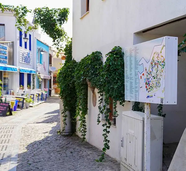
Türkiye’nin ilk sakin şehri Seferihisar’ın, tarihi Kaleiçi bölgesi ile ilgili yapılan haritalandırma çalışması tamamlandı. Kaleiçi’ne gelen ziyaretçiler, giriş noktalarına yerleştirilen haritalar üzerindeki karekodu okutarak, gitmek istedikleri adrese kolaylıkla ulaşabilecekler.Seferihisar Belediyesi, Sığacık’ta bulunan tarihi Kaleiçi bölgesi ile ilgili haritalandırma çalışması yaptı.Her yıl, on binlerce yerli ve yabancı turistin ziyaret ettiği ve araç girişinin olmadığı bölgede, adreslerin ...
turkiyeturizm.com

Le Géoportail De Santé Publique : Un Allié Pour Les Interventions En Santé

Le Géoportail de santé publique du Québec est une plateforme cartographique qui permet de visualiser la variation géographique d’indicateurs de santé et de ses déterminants partout au Québec. La plateforme est accessible à tous les organismes ainsi qu’au grand public. Des indicateurs sont aussi disponibles en lien avec la qualité de l’air et bruit environnemental, ...
cdeacf.ca

Ecuador Crea Su Primer Atlas Geográfico Y Estadístico Ambiental Y De Los Recursos Hídricos

Ecuador presentó su primer Atlas Geográfico y Estadístico Ambiental y de los Recursos Hídricos para facilitar el acceso a información oficial actualizada, validada y confiable sobre el patrimonio natural y los recursos hídricos, informó este viernes el Ministerio del Ambiente, Agua y Transición Ecológica. Esta herramienta de información está dividida en cinco secciones que contienen ...
lavanguardia.com

Iran Prepares New Satellite For Launch

The “Tolu’-3” (Sunrise-3) satellite, manufactured by Iran Electronics Industries, a subsidiary of the Iranian Defense Ministry, was delivered to the Space Organization on Saturday after passing the final tests. The homegrown satellite weighs over 100 kilograms and offers a resolution of 5 meters in panchromatic mode and 10 meters in multispectral mode. Tolu’-3 will be ...
tasnimnews.com

Chicago Uses Tech, Resident Input To Improve Services

The map-based Chicago Recovery Plan was created with feedback from residents. It also allows them to track progress on city projects to create safe neighborhoods and drive equitable economic growth. Launched in May 2023, the tool is “opening the books on neighborhood investments in a simple, accessible digital format,” Chief Technology Officer Nick Lucius said ...
govtech.com

Saint Louis University Receives $1 Million NGA Grant To Establish Midwestern Satellite Calibration Network

Saint Louis University has received a $1 million grant from the National Geospatial-Intelligence Agency (NGA) to create a satellite calibration network to improve the accuracy of satellite observations and the geospatial tools used to monitor global change, infrastructure resilience, and natural disasters such as landslides, volcanic eruptions, and flooding. The project, “Developing global InSAR solutions ...
slu.edu
What Are The Privacy Concerns When Using Satellite Imagery To Solve Crimes

What Are The Privacy Concerns When Using Satellite Imagery To Solve Crimes?

Once the sole domain of meteorologists and geographers, satellite imagery has become an increasingly useful tool for criminal investigations. Law enforcement agencies across the globe have taken advantage of the high-resolution images offered by satellite technology and are using greater quantities of such images than ever before to aid with investigations. In criminal cases where ...
aerotime.aero
AI2 Researchers Introduce Satlas A New AI Platform For Exploring Global Geospatial Data Generated By Artificial Intelligence From Satellite Imagery

AI2 Researchers Introduce Satlas: A New AI Platform For Exploring Global Geospatial Data Generated By Artificial Intelligence From Satellite Imagery

Manual curation of geospatial data, especially in the realm of renewable energy infrastructure and natural resource monitoring, involves a thorough process of aggregating, cleaning, and correcting datasets from various sources, often across multiple countries. This challenge has hindered efforts in emissions reduction, disaster relief, urban planning, and more, where precise geospatial insights are paramount. While ...
marktechpost.com