Geomaticians

01

안동시, 국내 석학 초청해 공간정보 발전 포럼 개최

안동시는 지난 29일 국내 공간정보 분야 석학을 초청해 ‘안동시 공간정보 발전 포럼’을 29일 시청 웅부관 청백실에서 개최했다. 시는 최근 국토교통부 ‘디지털 트윈 국토사업’과 국토지리정보원 ‘고정밀 전자지도 챌린저 공모사업’에 선정됐다. 디지털 트윈으로 대표되는 3차원 공간에 안동의 문화유산 콘텐츠와 수자원 인프라 등을 구현해 문화시설과 콘텐츠를 담은 고정밀 전자지도를 구축하고 홍수와 가뭄 등 재해에도 선제적으로 대응하는 다양한 시정 ...
metroseoul.co.kr
El Mapa De Calor Del Ayuntamiento De Madrid Descubre Si Vives En Una Zona Con Temperaturas “Extremadamente Altas”

El Mapa De Calor Del Ayuntamiento De Madrid: Descubre Si Vives En Una Zona Con Temperaturas “Extremadamente Altas”

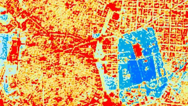
El Ayuntamiento de Madrid ha publicado un mapa en el que cada vecino puede comprobar si vive en un lugar afectado por su isla de calor o, por el contrario, resulta beneficiado gracias a la cercanía de parques como el Retiro, Casa de Campo o espacios de la periferia como Pradolongo, Entrevías o Valdebebas. Estos ...
eldiario.es

Das Geodatenportal Gibt’s Neu Auch In 3D

Das liechtensteinische Geoportal ermöglicht die Suche nach digitalen geographischen Informationen. Es enthält eine Fülle von Informationen übers Land – von sehr spezifischen Fakten wie etwa die Solarengerie-Eignung der Dächer, aber auch allgemeine Basis-Landkarten, raumplanerische Angaben oder Informationen über die Bodennutzung. Wie das Amt für Tiefbau und Geoinformation mitteilt, gibt’s das Ganze jetzt auch dreidimensional. Das ...
vaterland.li

با اتمام مرحله اول طرح «آمایش ملی فضاها، منابع و خدمات کتابخانه‌های عمومی کشور؛ سرور‌های نهاد کتابخانه‌‌های عمومی به نسخه پایه سامانه WebGIS مجهز می‌شود

جلسه ارائه گزارش مرحله اول طرح «آمایش ملی فضاها، منابع و خدمات کتابخانه‌های عمومی کشور در سامانه WebGIS، ۵ شهریورماه ۱۴۰۲ در کتابخانه مرکزی پارک شهر تهران برگزار شد. سید‌عباس رجایی، رئیس مؤسسۀ جغرافیای دانشگاه تهران، اظهار داشت: «فارغ از آمایش و نمایش اطلاعات کتابخانه‌ها بر روی وب، تحلیل‌ها و تعیین محدوده‌های خدمت نیز مطرح ...
ibna.ir
Ejecutivo Destinará Más De 12 Millones De Pesos A Fortalecer Gestión Territorial De Intendencias

Ejecutivo Destinará Más De 12 Millones De Pesos A Fortalecer Gestión Territorial De Intendencias

El ministro de Vivienda y Ordenamiento Territorial (MVOT), Raúl Lozano, suscribió convenios de cooperación financiera y técnica para el desarrollo y planificación territorial de los departamentos de Artigas, Cerro Largo, Durazno, Maldonado, Montevideo, Río Negro, Rivera, Rocha, Salto, Soriano, Tacuarembó y Treinta y Tres. Cada intendencia recibirá 1.100.000 pesos y se prevé ampliar dicho acuerdo ...
gub.uy
Mapping Rivers And Lakes With An Autonomous Watercraft

Mapping Rivers And Lakes With An Autonomous Watercraft

Surveying bodies of water accurately is a challenging task. Authorities and port operators are required to provide up-to-date maps of riverbeds and port facilities. Until now, this has required the use of special mapping vessels and a great deal of manpower. It is costly and is not being carried out with the frequency and precision ...
iosb.fraunhofer.de
New USGS National Map Data Reveals The Potomac River’s Submerged Topography

New USGS National Map Data Reveals The Potomac River’s Submerged Topography

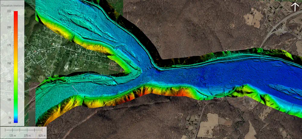
The U.S. Geological Survey recently published a new topobathymetric lidar dataset for the Potomac River as part of its 3D Elevation Program (3DEP). Topobathymetric lidar provides 3D maps of the submerged riverine topography. The maps were produced in two phases for more than 120 river miles of the Potomac River through a data-acquisition contract with ...
marinetechnologynews.com
Satellites Detect Where Locust Infestations Begin

Satellites Detect Where Locust Infestations Begin

Locusts can destroy grain crops and pastures, threatening people’s livelihoods. In an international project, researchers from the German Aerospace Center (Deutsches Zentrum für Luft- und Raumfahrt; DLR) have now developed methods to help detect locust outbreaks as early as possible and take action against them. Earth observation images acquired by satellites play a central role ...
dlr.de