Geomaticians

25

Septentrio Introduces New Open-Source Projects

Septentrio Introduces New Open-Source Projects

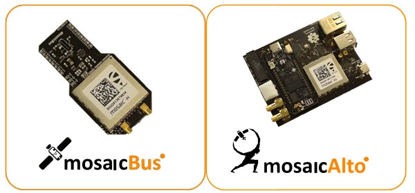
Septentrio has introduced two new open-source hardware projects available to integrators of satellite-based positioning. By expanding their ecosystem of open-source hardware and software, Septentrio aims to make reliable GNSS positioning more accessible to integrators and developers. The first project, mosaicBus, is a reference design of a board compatible with mikroBUS add-on board standards primarily used ...
gpsworld.com
Trimble Launches Technology To Reduce GNSS Signal Interruptions

Trimble Launches Technology To Reduce GNSS Signal Interruptions

Referred to as solar activity, ionospheric disturbances peak every 11 years. The next major disruption, Solar Cycle 25, is expected to peak between 2024 and 2026. Ionospheric activity can directly impact the quality of GNSS signals, leading to the degradation of position accuracy. While this type of disturbance has the greatest impact on high precision ...
gpsworld.com
City Planning Announces NYC Street Map To Show Historical Information About City

City Planning Announces NYC Street Map To Show Historical Information About City

On October 12, 2023, Department of City Planning Director Dan Garodnick announced that the NYC Street Map will now include access to the original street mapping of the City. Users can see the width, angles, and other dimensions of the City’s over 32,000 streets when utilizing the interactive map for requests to change their street, ...
citylandnyc.org

Transportes Firma Un Convenio Con La Asociación Española De Geografía Para Asegurar La “Excelencia” Del Atlas Nacional De España

El Ministerio de Transportes, Movilidad y Agenda Urbana ha firmado, a través del Instituto Geográfico Nacional (IGN) y el Centro Nacional de Información Geográfica (CNIG), un convenio con la Asociación Española de Geografía (AGE) para “asegurar la excelencia científica” del Atlas Nacional de España. Según el departamento dirigido por Raquel Sánchez, el objeto de este ...
lavanguardia.com
How This App Is Helping The Visually Impaired Navigate Around Airports

How This App Is Helping The Visually Impaired Navigate Around Airports

Ever wonder where you were at an airport or transit station and needed to find your gate or a restroom? GoodMaps, based out of Louisville, Kentucky, is working on an app to use your smartphone’s features to help you find your place. GoodMaps will come to a venue like an airport or a transit agency ...
simpleflying.com
Google Maps And Waze Temporarily Disable Live Traffic Data In Israel

Google Maps And Waze Temporarily Disable Live Traffic Data In Israel

Google is temporarily disabling live traffic conditions on its mapping service apps, Google Maps and Waze, in Israel, the tech company confirmed Monday, as the country prepares for a potential ground invasion into Gaza. “As we have done previously in conflict situations and in response to the evolving situation in the region, we have temporarily ...
cnn.com
Imágenes Satelitales Ópticas Y De Radar, Claves Para El Monitoreo De Cultivos De Papa

Imágenes Satelitales Ópticas Y De Radar, Claves Para El Monitoreo De Cultivos De Papa

La producción de papa, uno de los tubérculos más importantes para la canasta básica diaria familiar de los colombianos, además de presentar desafíos como el incremento de los costos de transporte e insumos para su cultivo que afectan el bolsillo de los productores, es constantemente vulnerable a que la sobreoferta, producto muchas veces de la ...
agronegocios.co
Seminario Revelará Proyecto Que Utiliza Sensores Remotos Para Impulsar La Apicultura Natural Regenerativa

Seminario Revelará Proyecto Que Utiliza Sensores Remotos Para Impulsar La Apicultura Natural Regenerativa

Un enfoque que destaca la conservación de la diversidad floral natural como base para la alimentación de las abejas melíferas, es el que tiene el proyecto “Sensores remotos y apicultura natural regenerativa”, que desde 2022 desarrollan investigadores de INIA Quilamapu en la región de Ñuble. El investigador y director del proyecto, Marcelino Claret, indicó que ...
mundoagro.cl
New Study Shows Surprising Effects Of Fire In North America’s Boreal Forests

New Study Shows Surprising Effects Of Fire In North America’s Boreal Forests

A new study, using a first-of-its-kind approach to analyze satellite imagery from boreal forests over the last three decades, found that fire may be changing the face of the region in a way researchers did not previously anticipate. Historically, fires in North American boreal forests have led to coniferous trees being supplanted by deciduous trees, ...
eurekalert.org
KICT Develops Scan To BIM For Reverse Engineering From 3D Vision Data

KICT Develops Scan To BIM For Reverse Engineering From 3D Vision Data

Korea Institute of Civil Engineering and Building Technology (KICT, President Kim Byung-suk) has developed building scan to BIM (Building Information Modeling)-based reverse engineering technology required for 3D geospatial information modeling domains such as digital twin information modeling. Scan to BIM-based reverse engineering technology was studied to prevent errors and rework caused by manual work when ...
eurekalert.org