Geomaticians

May

Could AI Save The Amazon Rainforest

Could AI Save The Amazon Rainforest?

The tool, PrevisIA, is an artificial intelligence platform created by researchers at environmental nonprofit Imazon. Instead of trying to repair damage done by deforestation after the fact, they wanted to find a way to prevent it from happening at all. According to SAD, Imazon’s Deforestation Alert System, deforestation this March tripled compared to the same ...
theguardian.com

Tracasa Global Implantará El Sistema GIS Para Gestionar Las Redes De Agua En 11 Municipios De La Costa Del Sol

Tracasa Global, empresa pública del Gobierno de Navarra, implantará el sistema de información geográfica (GIS) para la gestión de redes de agua en Acosol, que da servicio a 11 municipios de la Costa del Sol, en la provincia de Málaga. La empresa navarra, que comenzará a introducir sus servicios GeoSAS -con la tecnología Utility Network ...
aguasresiduales.info

Pianificazione Forestale Di Precisione E Tecnologia Lidar

Come ha dimostrato la tempesta Vaia e l’attuale epidemia di bostrico, i cambiamenti climatici possono mettere a dura prova le foreste dell’arco alpino. Anche la programmazione della gestione forestale deve essere affrontata con strumenti al passo con i tempi. In Provincia di Bolzano l’intera superficie forestale viene gestita attraverso strumenti di pianificazione decennali attraverso circa ...
news.provincia.bz.it
Instituto Pereira Passos E Rice University Firmam Acordo De Cooperação Para Enriquecer Atlas Digital Sobre O Rio De Janeiro

Instituto Pereira Passos E Rice University Firmam Acordo De Cooperação Para Enriquecer Atlas Digital Sobre O Rio De Janeiro

O Instituto Pereira Passos, órgão da Prefeitura do Rio, anunciou nesta terça-feira (02/05) um acordo com a Rice University, instituição de ensino superior americana sediada em Houston, para cooperação em cima da plataforma imagineRio, um atlas digital pesquisável que ilustra a evolução social e urbana da cidade ao longo de toda a sua história. Com ...
prefeitura.rio
Morelia, Tarímbaro Y Charo, Suman Esfuerzos Para Un Desarrollo Metropolitano En Orden

Morelia, Tarímbaro Y Charo, Suman Esfuerzos Para Un Desarrollo Metropolitano En Orden

Al determinar que a través del trabajo coordinado se avanza mucho mejor en el desarrollo de los municipios, el Alcalde, Alfonso Martínez Alcázar, auguró que será de gran apoyo la firma de convenio de colaboración entre Morelia, Charo y Tarímbaro en aras de establecer un mejor intercambio y transferencia de información geográfica y estadística, con ...
morelia.gob.mx

RGPH 2024 : Lancement Des Travaux Cartographiques Préparatoires

Cette opération, qui va se dérouler pendant 14 mois sur le terrain, consiste à géoréférencer l’ensemble des logements, des établissements économiques et administratifs et des équipements socio-culturels existants sur l’ensemble du territoire national et de subdiviser ce dernier en unités géographiques dites “districts de recensements”, indique un communiqué du HCP. La cartographie des établissements économiques ...
perspectivesmed.com
Antarktika Bilim Seferi'nin Haritacıları, Beyaz Kıta'da Piri Reis'in Izinde

Antarktika Bilim Seferi’nin “Haritacıları”, Beyaz Kıta’da Piri Reis’in Izinde

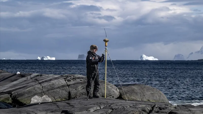
Milli Savunma Bakanlığına bağlı Harita Genel Müdürlüğü ve Türk Deniz Kuvvetleri Seyir, Hidrografi ve Oşinografi Dairesi Başkanlığı, 7. Ulusal Antarktika Bilim Seferi’ne katılarak, Piri Reis’in izinde, kıtada denizden ve karadan koordinatları belirlemeye yönelik ölçümler yaptı. Cumhurbaşkanlığı himayelerinde, Sanayi ve Teknoloji Bakanlığı uhdesinde, TÜBİTAK MAM Kutup Araştırmaları Enstitüsü koordinasyonunda gerçekleştirilen 7. Ulusal Antarktika Bilim Seferi kapsamında, ...
aa.com.tr

GeoComm Announces Availability Of School Mapping Solution Designed To Accelerate School Incident Response

GeoComm, provider of Public Safety Location Intelligence®, is excited to announce the availability of GeoComm School Safety, a digital mapping solution which leverages the latest Esri ArcGIS technology to support faster response to school emergencies. The solution provides detailed indoor maps of schools and surrounding grounds, along with critical information needed by school safety authorities, ...
directionsmag.com
ICEYE Announces Beta Release Of Wildfire Data Product

ICEYE Announces Beta Release Of Wildfire Data Product

ICEYE, a provider of natural catastrophe insights, has announced the beta release of its Wildfire Insights product. ICEYE Wildfire uses artificial intelligence and machine learning to provide building-level impact data for wildfires in near real time based on satellite imagery. The product captures data for any wildfire that impacted communities throughout the US, ICEYE said. ...
insurancebusinessmag.com
Cold Atoms For New Physics

Cold Atoms For New Physics

On 13 and 14 March CERN hosted an international workshop on atom interferometry and the prospects for future large-scale experiments employing this quantum-sensing technique. This quantum sensing technology holds great promise for making ultra-sensitive measurements in fundamental physics. Like light interferometry, atom interferometry involves measuring interference patterns, but between atomic wave packets rather than light ...
cerncourier.com
Map Shows Heartworm Rates Continue To Increase In Hot Spots, New Locations

Map Shows Heartworm Rates Continue To Increase In Hot Spots, New Locations

Incidence of heartworm disease has continued to rise not only in previously known hot spots but also in unexpected locations with previously low heartworm rates, according to the 2022 Heartworm Incidence Map from the American Heartworm Society (AHS). “For many pet owners—and even veterinarians—it can be all too easy to assume that heartworm isn’t common ...
avma.org
New 3D Maps Reveal Hundreds Of Ancient Landslides South Of Auckland

New 3D Maps Reveal Hundreds Of Ancient Landslides South Of Auckland

Just-released maps have revealed hundreds of ancient landslides around Pukekohe, while offering a multi-dimensional view of the region’s active faults and volcanic features. Capturing more than 830 square kilometres, from Manukau Harbour’s southern shoreline to the lower Waikato River, the new GNS Science-produced maps show Auckland’s rolling southern landscapes as they’ve never been seen. It ...
nzherald.co.nz
Mapping And Health Equity Project Created By UIC Alum, Student Addresses Chicago’s Health Disparities

Mapping And Health Equity Project Created By UIC Alum, Student Addresses Chicago’s Health Disparities

Near the end of the 2019 fall semester, Sonya Gupta was a University of Illinois Chicago undergraduate conducting research on the location and extent of healthcare deserts in the Chicago area and the potential of mobile health clinics to bridge the gap … In the fall of 2020, biological sciences major Ryan Zomorrodi started research ...
today.uic.edu

Synspective And Thaicom Partner On Disaster Response In Southeast Asia

Imagery startup Synspective and regional operator Thaicom are partnering to jointly offer synthetic aperture radar (SAR) for disaster response in Thailand. The two companies announced Tuesday they plan to offer a solution to government, defense, agriculture, and finance sectors in Thailand, with Synspective’s SAR technology and Thaicom’s knowledge of the satellite and space sector in ...
satellitetoday.com
Nexar Revolutionizes Map-Making With 40x Reduction In Real-time Mapping Costs

Nexar Revolutionizes Map-Making With 40x Reduction In Real-time Mapping Costs

Nexar, the leading real-time mapping company, announced today it has achieved a dramatic 40x reduction in the cost of real-time mapping by leveraging cutting-edge technologies, edge AI, change detection and crowdsourcing. As a result, Nexar’s CityStream Live platform is making real-time mapping data more accessible to the mobility industry than ever before. Nexar dramatically reduces ...
prnewswire.com
Overture Maps Foundation Releases Preliminary Map Dataset

Overture Maps Foundation Releases Preliminary Map Dataset

The Overture Maps Foundation, a community-driven effort to develop an open map dataset built for map service providers, last month announced the first public showing of their work in what they are referring to as a “pre-release.” The Overture Maps Foundation was officially formed last December in an effort headed by the Linux Foundation with ...
geoweeknews.com
Leica Geosystems Introduces The Next Evolution In Smart, Autonomous Mobile Mapping

Leica Geosystems Introduces The Next Evolution In Smart, Autonomous Mobile Mapping

Leica Geosystems, part of Hexagon, today announced the latest addition to its Leica Pegasus TRK portfolio of mobile mapping solutions, the Leica Pegasus TRK100. Specifically designed for GIS professionals, the new mobile mapping system is a powerful, easy-to-use geospatial solution built for large-scale infrastructure measurement and digital twin creation. The Pegasus TRK100 is designed to ...
directionsmag.com

Sanborn, An Authority In 3D Models, Pioneers The Digital Twin Base Map

Developed by leading tech firm The Sanborn Map Company (Sanborn), this innovative technology sets a new standard for urban analysis, implementation of Digital Cities, navigation, and planning with a fundamental transformation from a 2D map environment to a 3D environment. Sanborn’s Digital Twin Base Map is a high-resolution 3D map providing reliable mapping information with ...
businesswire.com
Mapeamento Por Imagens De Satélite Identifica Viveiros De Produção Aquícola No Brasil

Mapeamento Por Imagens De Satélite Identifica Viveiros De Produção Aquícola No Brasil

A Embrapa mapeou, com imagens de satélite, mais de 78 mil hectares de viveiros escavados para produção aquícola no Brasil. A pesquisa gerou um banco de dados inédito no País, com a localização e os limites de 48,5 mil conjuntos de viveiros – chamados de baterias. Em cada estado, foram analisados os municípios que respondem ...
embrapa.br
Estudian Con Realidad Virtual El Impacto Del Fracking En Vaca Muerta

Estudian Con Realidad Virtual El Impacto Del Fracking En Vaca Muerta

El impacto de la industria petrolera en Vaca Muerta y el avance del fracking en las zonas productivas se investiga y mide en la región. Van identificando las áreas de riesgo. El uso de realidad virtual fue el gran atractivo. La mayoría de los participantes se colocaron los anteojos y navegaron la Cuenca del Comahue. ...
rionegro.com.ar
A Map Of Every Tree In Africa Will Help Monitor Deforestation

A Map Of Every Tree In Africa Will Help Monitor Deforestation

High-resolution satellite imagery has been used to map every single tree in Africa, demonstrating a technique that could help improve the monitoring of deforestation across the world. Florian Reiner at the University of Copenhagen, Denmark, and his colleagues used images from satellites operated by US firm Planet and machine-learning models to map canopy cover across ...
newscientist.com
자율주행용 정밀도로지도, 일반 국도까지 지원한다

자율주행용 정밀도로지도, 일반 국도까지 지원한다

국토교통부 국토지리정보원은 고속국도와 일반국도를 대상으로 자율주행의 핵심 인프라인 정밀도로지도 구축을 완료하고 지난달 27일부터 무상으로 제공하고 있다. 정밀도로지도는 차선, 표지, 도로시설 등을 도로 디지털트윈으로 구현한 고정밀 전자지도로 차선 단위의 차량위치 결정이 가능해 자율주행을 지원하도록 제작된 지도를 말한다. 자율주행 뿐만 아니라 고정밀 내비게이션과 운전 중 발생할 수 있는 상황을 차량이 스스로 인지해 판단하는 전자 제어 시스템인 ADAS(Advanced ...
hellot.net
광주시, AI·빅데이터 활용 미래형 스마트 교통도시로 거듭난다

광주시, AI·빅데이터 활용 미래형 스마트 교통도시로 거듭난다

광주시는 지능형교통체계(ITS) 스마트 횡단보도를 구축하고 교통안전시설물 관리시스템을 추진하는 등 미래형 스마트 교통도시로 거듭난다고 2일 밝혔다. 시는 광주경찰청 교통안전시설 담당자들과 워크숍을 열어 교통시설 추진정책 및 확충분야를 심도 있게 논의, 시민 불편은 줄이고 교통안전은 높이는 ‘2023년 미래형 교통시설 중점 추진 정책’을 마련해 이날 발표했다. 먼저 AI 센서와 빅데이터를 활용한 ITS 스마트횡단보도 구축사업을 추진한다. 스마트횡단보도는 첨단센서 기술로 보행자와 ...
chum-dan.net
El Primer Mapa De Riesgos Climáticos En Canarias Detalla Qué Municipios Sufrirán Más Los Efectos Del Calentamiento Global

El Primer Mapa De Riesgos Climáticos En Canarias Detalla Qué Municipios Sufrirán Más Los Efectos Del Calentamiento Global

El impacto de la crisis climática no será igual en toda Canarias. Nuevos datos difundidos por el Gobierno regional revelan que municipios como Pájara, en Fuerteventura, o Haría, en Lanzarote, sufrirán más los efectos del calentamiento global en sus costas que otras regiones del Archipiélago. Los resultados concluyen, de nuevo, que la dependencia del turismo ...
eldiario.es

پرتاب سری «ماهواره‌های پارس» و «طلوع» در سال جاری

رئیس سازمان فضایی ایران از پرتاب ماهواره‌هایی در سال جاری خبر داد و گفت: در سال جاری سری ماهواره‌های پارس (پارس ۱ و ۲) به عنوان جفت ماهواره، ماهواره طلوع با دقت ۱۰ متر رنگی آماده پرتاب می‌شوند. رئیس سازمان فضایی ایران ادامه داد: علاوه بر آن قرارداد، در حال پیگیری انعقاد قرارداد برای ساخت ...
khabaronline.ir

Integran En Una Plataforma Información Sobre El Envejecimiento En México

Esta plataforma de libre acceso fue desarrollada por el Instituto de Geografía (IGg) de la UNAM, el Instituto Nacional de Geriatría (INGER), la Universidad de Colima y CHRISTUS Centro de Excelencia e Innovación. En la conformación del SIESDE colaboraron médicos, geógrafos, demógrafos, ingenieros y científicos de datos, en un trabajo enmarcado en la perspectiva del ...
dgcs.unam.mx
Track, Trace And Triumph How Utah Division Of Wildlife Resources And Google Public Sector Are Setting The Standard To Protect The State’s Wildlife

Track, Trace And Triumph: How Utah Division Of Wildlife Resources And Google Public Sector Are Setting The Standard To Protect The State’s Wildlife

Fast forward to 2023, and now Utah DWR officials can get real-time location data for thousands of animals without leaving their office. What’s more, they can overlay today’s location data with up to 20 years of historical information to make data-driven decisions to improve wildlife habitat and populations using the state’s Wildlife Tracker application, running ...
utahbusiness.com
El Nuevo Sistema De La UMA Que Detecta Las Zonas De Humedales

El Nuevo Sistema De La UMA Que Detecta Las Zonas De Humedales

Este sistema, según Christoph Schröder , especialista en Sistemas de Información Geográfica del ETC-UMA, se encarga de mapear con imágenes satélite las extensiones de agua de los humedales, a partir de una herramienta que desde la nube ‘Google Earth Engine’ calcula y observa la evolución de una serie de indicadores como pueden ser el agua ...
malagahoy.es
Geographic Technology Provides Landowners With Precise Tools When Making Land Management Decisions

Geographic Technology Provides Landowners With Precise Tools When Making Land Management Decisions

According to Lee Burras and Bradley Miller, agronomists at Iowa State University, advances in geospatial technology coupled with more traditional farming knowledge have allowed researchers and landowners to understand the land more intimately than ever before. Miller, who began his career working in water quality, has seen firsthand how soil can be impacted by the ...
extension.iastate.edu
Geospatial World Forum 2023 To Be Held In Rotterdam In May

Geospatial World Forum 2023 To Be Held In Rotterdam In May

The Geospatial World Forum (GWF) is gearing up for its 14th edition, and it promises to be a must-attend event for professionals in the geospatial industry. With expected participation of 800+ attendees from more than 75 countries, the GWF is set to be a global gathering of industry leaders, innovators, and experts. More than 300 ...
geospatialworld.net