Geomaticians

May

Desmatamento Em Terras Públicas Não Destinadas-4 A Área De Estudo

Desmatamento Em Terras Públicas Não Destinadas-4: A Área De Estudo

O estudo foi realizado no distrito de Santo Antônio do Matupi. “Distritos” são unidades administrativas dentro de um município, neste caso o município de Manicoré na porção sul do estado do Amazonas. O distrito de Matupi, também conhecido como “km 180”, está localizado na rodovia Transamazônica (BR-230). Esta estrada principal faz a ligação com o ...
amazoniareal.com.br
Google Maps Is Expanding Immersive View To Routes

Google Maps Is Expanding Immersive View To Routes

Google Maps is expanding the Immersive View format it revealed last year to an important part of the app: routes. When you look for directions in Google Maps on iOS and Android in select cities, you’ll see a more detailed view of the route. The feature isn’t just about making your journey look nicer than ...
engadget.com

NavVis Releases VLX 3 Mobile Mapping System

On Tuesday, NavVis, one of the leaders in wearable mobile mapping technologies, unveiled their next generation of wearable technology, the NavVis VLX 3. This is, as the name implies, the third generation of their wearable VLX system, with the NavVis VLX 2 having been released almost two years ago in July of 2021. In their ...
geoweeknews.com
인파 밀집 ‘위험 경보’ 시스템 만든다…5분 단위로 데이터 수집

인파 밀집 ‘위험 경보’ 시스템 만든다…5분 단위로 데이터 수집

행정안전부는 기지국 접속 정보와 공간 정보 등을 수집, 분석해 밀집도를 모니터링하는 현장인파관리시스템 구축사업을 이달 중 착수해 올해 안에 완료하겠다고 10일 밝혔다. 지난달 4월 27일 국회를 통과한 뒤 9일 국무회의에서 의결된 ‘재난안전법’ 개정안은 기지국 접속 정보를 정부나 지방자치단체가 요청할 경우 이동통신사가 즉시 제공할 수 있도록 하는 내용을 담고 있다. 행안부가 구상하는 ‘현장인파관리시스템’은 이 개정안을 근거로 유동인구를 ...
hani.co.kr

Nowa Aplikacja Bukle App Do Planowania Podróży Komunikacją Miejską

Najważniejszą funkcją systemu to możliwość dodania do niego rozkładów jazdy dowolnej firmy transportowej. Celem projektu jest dotarcie do lokalnych przewoźników i przekonanie ich do umieszczenia i (regularnego) aktualizowania swoich rozkładów jazdy, ponieważ serwis pozwala na samodzielne zarządzanie rozkładem przez firmy transportowe. Aplikacja wyznacza połączenia między dwoma miejscami z możliwymi przesiadkami, pozwala zobaczyć czasy odjazdów czy ...
gisplay.pl
3D-Modell Und Sensoren - Memmingen Digital

3D-Modell Und Sensoren – Memmingen Digital

Wieviele Fußgänger sind in Memmingen gerade in der Kramerstraße unterwegs? Wie ist die aktuelle Temperatur am Weinmarkt? Wie voll sind die Wertstoffcontainer am Westertor? Das alles messen neu installierte Sensoren – und ihr könnt diese Infos einfach online über den Digitalen Zwilling der Stadt Memmingen per Maus-Klick abrufen. Das Projekt ist jetzt auch dem Memminger ...
imsueden.de

Gemeinsam Zum Ziel: Citizen Science Liefert Wertvollen Beitrag Zur Verhaltensbeobachtung Von Vögeln

Langfristige Aufzeichnungen von Daten über das Verhalten von Tieren stellen für die Wissenschaft wichtige Quellen für die Entwicklung von neuen, überprüfbaren Hypothesen dar. Für die Erfassung solcher Langzeitdaten ist die Einbeziehung und Beteiligung von Bürgerwissenschafter*innen ein Gewinn für Wissenschaft und Gesellschaft. Inwieweit die so erhobenen Daten auch verlässlich sind, hat ein Forschungsteam rund um Didone ...
idw-online.de
Un Sistema Basado En Sensores Ópticos Y Algoritmos Detectará Fisuras En Las Vías Férreas

Un Sistema Basado En Sensores Ópticos Y Algoritmos Detectará Fisuras En Las Vías Férreas

La Escola de Enxeñaría Aeronáutica e do Espazo del campus de Ourense reunió este martes a expertos en infraestructuras y mantenimiento en el sector ferroviario para conocer los avances del proyecto RIIM, en el que trabajan investigadores del grupo de Ingeniería Física de este centro y la empresa Copasa. El objetivo de esta investigación, explicaron, ...
Map Of Crimes In Park Ridge Will Update Every Week, Per Police

Map Of Crimes In Park Ridge Will Update Every Week, Per Police

The Park Ridge Police Department has rolled out an interactive map to track where criminal activity takes place across Park Ridge. The map, available on the Park Ridge Police Department website, is a response to a request from aldermen earlier this year to have a better idea of where crimes are occurring in Park Ridge. ...
chicagotribune.com
NASA, Rocket Lab Launch Tropical Storm Observing CubeSats

NASA, Rocket Lab Launch Tropical Storm Observing CubeSats

NASA and Rocket Lab launched two of the agency’s CubeSats on Sunday to study tropical cyclones with greater frequency than existing satellites, according to an agency announcement. The CubeSats were launched on an Electron Rocket from Rocket Lab’s Launch Complex in New Zealand at 9pm EDT on Sunday—or 1pm NZST on Monday. The launch was ...
nextgov.com
Submerged Lidar Acquires 3D Images Underwater

Submerged Lidar Acquires 3D Images Underwater

A project from Heriot-Watt University and the University of Edinburgh has now developed what it says is the first fully submerged lidar underwater transceiver system based on single-photon detection, and published the results in Optics Express. Heriot-Watt employed a CMOS-fabricated silicon single-photon avalanche diode (SPAD) detector to measure photon time-of-flight using picosecond resolution time-correlated single-photon ...
optics.org
I Turisti Mappati Dal Cellulare

I Turisti Mappati Dal Cellulare

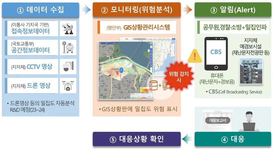
I dati di telefonia mobile possono aiutare la gestione dei flussi turistici, attraverso la produzione di statistiche complementari a quelle ufficiali esistenti, che possono innovare e migliorare le stesse. È la conclusione, che conferma le sperimentazioni internazionali, alla quale sono arrivati i ricercatori che, sulla base della collaborazione tra Istat e Vodafone Business Italia. I ...
metropolitano.it
Using Reflections To See The World From New Points Of View

Using Reflections To See The World From New Points Of View

A new computer vision system turns any shiny object into a camera of sorts, enabling an observer to see around corners or beyond obstructions. researchers from MIT and Rice University have created a computer vision technique that leverages reflections to image the world. Their method uses reflections to turn glossy objects into “cameras,” enabling a ...
news.mit.edu
SAS Seeks Crowd-driven AI To Protect Endangered Sea Turtles In Galapagos

SAS Seeks Crowd-driven AI To Protect Endangered Sea Turtles In Galapagos

As an organization dedicated to responsible innovation and using technology to ignite positive change, SAS will apply crowd-driven AI and machine learning to help protect endangered sea turtles. Similar to SAS’ recent project to help track deforestation in the Amazon, the analytics leader is now working with the UNC Center for Galapagos Studies (CGS) to ...
research.unc.edu
Earth’s Climate Is Changing. IBM’s New Geospatial Foundation Model Could Help Track And Adapt To A New Landscape

Earth’s Climate Is Changing. IBM’s New Geospatial Foundation Model Could Help Track And Adapt To A New Landscape

Nearly a quarter of the world’s population now lives in a flood zone, and that number is expected to climb as rising seas and heavier storms triggered by a changing climate put more people at risk. The ability to accurately map flooding events can be key to not only protecting people and property now but ...
research.ibm.com

Altair Releases SimSolid Cloud Simulation Software

Late last month, simulation and artificial intelligence specialist Altair announced the release of their latest software offering, Altair SimSolid Cloud. The cloud-native simulation software offers convenience, with the ability to be used on any web browser from any device, and improved efficiency. To that latter point, Altair says “SimSolid Cloud eliminates geometry simplification and meshing, ...
geoweeknews.com
A NEW ‘Bird’s Eye View’ Map Of Glasgow Has Been Created By A City Artist – Almost 160 Years After The Original Caused A Sensation.

A NEW ‘Bird’s Eye View’ Map Of Glasgow Has Been Created By A City Artist – Almost 160 Years After The Original Caused A Sensation.

Will Knight used drones to help him make the artwork, which is an incredibly detailed snapshot of modern Glasgow, while his predecessor, Thomas Sulman, did his research in a hot air balloon. Now, both the Sulman map of 1864 and the Knight map are being displayed side by side in an exhibition at the New ...
glasgowtimes.co.uk
Understanding Flood Behavior With Underground Lidar Data

Understanding Flood Behavior With Underground Lidar Data

Mobile lidar scanners are mapping underground spaces in Belfast to better understand and prepare for coastal flooding. The use of SLAM-based systems provides greater clarity of large flood risk areas for surveyors, through the creation of flood models. Globally, lidar solutions help to create the foundations for flood modeling of large areas, however, they seldom ...
geoweeknews.com
OpenAI’s Shap-E Model Makes 3D Objects From Text Or Images

How Space Will Help Football Fans To Celebrate Sport

Millions of supporters avidly follow football clubs across Europe, from Manchester United to Bayern Munich. Now ESA is partnering with UEFA to use space to help ensure the safety of football fans and the sustainability of the sport – as well as exploring other ways in which space can help promote football. he project aims ...
esa.int
Trees Are Moving North From Global Warming. Look Up How Your City Could Change.

Trees Are Moving North From Global Warming. Look Up How Your City Could Change.

As greenhouse gas emissions nudge temperatures higher, trees’ growing ranges are shifting northward, projections from the U.S. Forest Service show. Trees near the southern edge of their geographic ranges — what scientists refer to as “plant hardiness zones” — will be left behind, while northern latitudes will welcome new species from the south. Plant hardiness ...
washingtonpost.com
OpenAI’s Shap-E Model Makes 3D Objects From Text Or Images

OpenAI’s Shap-E Model Makes 3D Objects From Text Or Images

Recently, we’ve seen AI models that produce detailed text-to-video or use run a chatbot on your phone. Now, OpenAI, the company behind ChatGPT, has introduced Shap-E, a model that generates 3D objects you can open in Microsoft Paint 3D or even convert into an STL file you can output on one of the best 3D ...
tomshardware.com
European Environment And Health Atlas Goes Live

European Environment And Health Atlas Goes Live

The interactive online tool, a first on such a scale for all of Europe, allows users to visualise how the environment around them affects their health and well-being via set of detailed maps. It covers topics like air quality, noise and quietness, green and blue spaces and climate change throughout the member and collaborating countries ...

Collecte De Données Satellitaires : Le Projet SenSpatial En Mode Décollage

En matière de données géospatiales, le Sénégal vise très haut. Les acteurs de l’écosystème, regroupés au sein du Groupe Interinstitutionnel de Coordination et de Concertation en Géomatique (GICC), ont tenu ce jeudi le premier Comité de Pilotage de lancement du projet SEN Spatial. Un projet ambitieux qui va permettre de poursuivre l’apprentissage pour faire du ...
seneweb.com

Scientists From Country’s Top Space Research Institutes Join Climate Change Deliberations At Kashmir University

Distinguished scientists from the country’s top research organisations involved in satellite earth observation including ISRO and other institutions of national importance joined deliberations on the use of satellite earth observation for climate services during a national-level workshop on ‘Earth Observations for Climate Services’ at the University of Kashmir on Thursday. Vice-Chancellor Prof Nilofer Khan inaugurated ...
greaterkashmir.com

Cispa-forscher Christoph Lenzen Erhält Erneut Proof Of Concept Grant Vom ERC

Der aktuelle Mobilfunkstandard 5G sowie das in der Entwicklung befindliche 6G versprechen immens schnelle Datenübertragungsraten und eröffnen damit ganz neue Möglichkeiten. Das in der Informatik altbekannte Problem, große verteilte Netzwerke zeitlich synchron zu halten, sorgt allerdings dafür, dass das volle Potenzial der neuen Technologien kaum ausgeschöpft werden kann. CISPA-Faculty Dr. Christoph Lenzen und sein Team ...
idw-online.de
Entwicklung Neuer Messtechniken In Der Geodäsie

Entwicklung Neuer Messtechniken In Der Geodäsie

Im EU-Forschungsprojekt „Large-scale dimensional measurements for geodesy“ (GeoMetre) entwickelten Forschende der Frankfurt University of Applied Sciences (Frankfurt UAS) und weiterer europäischer Wissenschaftsinstitutionen feldtaugliche Systeme und Analysestrategien zur Verbesserung der Genauigkeit und Rückführbarkeit geodätischer Längenmessungen. Das vom Forschungs- und Innovationsprogramm der Europäischen Union Horizon 2020 (18SIB01) geförderte Projekt verzeichnet schon Erfolge: Die neuen Messinstrumente und -techniken ...
innovations-report.de
Spacex Wyniesie Polskiego Satelitę. Start Już W Tym Roku

Spacex Wyniesie Polskiego Satelitę. Start Już W Tym Roku

W październiku br. będziemy świadkami wyniesienia w przestrzeń kosmiczną kolejnego satelity pochodzącego z Polski. Celem misji kosmicznej Intuition-1 jest wykonywanie zobrazowań Ziemi z wykorzystaniem satelity z instrumentem hiperspektralnym oraz zaawansowaną jednostką do przetwarzania danych na pokładzie opartej o głębokie sieci neuronowe w postaci komputera pokładowego – Leopard. Będzie to pierwszy na świecie satelita o mocy ...
space24.pl
Per Migliorare La Produzione Del Fotovoltaico Sul Tetto Arriva Il Catasto Solare 3D Di ENEA

Per Migliorare La Produzione Del Fotovoltaico Sul Tetto Arriva Il Catasto Solare 3D Di ENEA

Un potenziale incredibile non sfruttato, è quello rappresentato dalle coperture degli edifici nelle città italiane. Installare il fotovoltaico sul tetto potrebbe contribuire significativamente alla produzione energetica nazionale fornendo addirittura tra i 70 e i 90 GW di potenza complessiva. Per calcolare il potenziale di energia fotovoltaica installabile sui tetti e su ogni superficie urbana idonea, ...
rinnovabili.it
Realiza UNAM Monitoreo Satelital Permanente Para Detectar Incendios Forestales

Realiza UNAM Monitoreo Satelital Permanente Para Detectar Incendios Forestales

Ante el incremento de incendios forestales en nuestro país, el año pasado consumieron más de 730,000 hectáreas de bosques y selvas, investigadores del Instituto de Geografía (IGf) de la UNAM, realizan un monitoreo satelital permanente a través de un sistema automatizado de visualización para la detección de puntos de calor que permite alertar de forma ...
imagenagropecuaria.com
New Startup Nuview Targets Commercial Lidar Satellite Constellation

New Startup Nuview Targets Commercial Lidar Satellite Constellation

New geospatial satellite startup Nuview emerged from stealth mode on Thursday, with plans to build the first commercial LiDAR satellite constellation. A Nuview representative told Via Satellite the company aims to have a 20-satellite constellation, with tentative launch of the first satellites in 24 to 36 months. The company plans to launch satellites in groups ...
satellitetoday.com