Geomaticians

May

A Better Way To Match 3D Volumes

A Better Way To Match 3D Volumes

By mapping the volumes of objects, rather than their surfaces, a new technique could yield solutions to computer graphics problems in animation and CAD. In computer graphics and computer-aided design (CAD), 3D objects are often represented by the contours of their outer surfaces. Computers store these shapes as “thin shells,” which model the contours of ...
news.mit.edu

인천 중·북부 상수도 시설,, 지리정보 시스템 갖춘다

인천시는 22일 북부, 중부의 총 133.56㎞에 달하는 상수도 시설물의 위치와 깊이 등 정보의 정확도를 높이기 위한 ‘2023년 상수도 지리정보시스템(GIS 정보 수정・갱신사업)’의 착수했다. 이번 사업은 기존에 단순 도면 전산화로 구축한 기존 상수관로 지리정보시스템(GIS) 정보를 위성통신을 활용해 상수시설물의 위치, 깊이, 관 재질 등 정보를 갱신하고 측정 정보 지리정보시스템(GIS)을 개선하는 사업이다. 부평정수장 탐사측량 시연회에서 전자유도탐사기·토탈스테이션 등의 장비를 동원해 ...
newsfreezone.co.kr
Un Proyecto Realizará Un Mapa Actualizado De La Presencia De Garrapatas En España

Un Proyecto Realizará Un Mapa Actualizado De La Presencia De Garrapatas En España

La importancia de las garrapatas ha trascendido el ámbito veterinario y se ha convertido en un problema sanitario de creciente actualidad. Enfermedades como Lyme, Rickettsiosis o Enfermedad Hemorrágica Crimea Congo son habitualmente diagnosticadas en nuestro país. Además, el cambio global está permitiendo la dispersión de algunas especies de garrapatas produciendo una creciente alarma social. En ...
interempresas.net
Alumnos De La UJED Destacan En Congreso Nacional De Geomática

Alumnos De La UJED Destacan En Congreso Nacional De Geomática

En este congreso, tres estudiantes de la maestría tuvieron la oportunidad de presentar sus trabajos de investigación, lo cual es fundamental para su formación profesional y les permite intercambiar conocimientos y generar nuevas ideas junto a sus compañeros de otras instituciones. Maritza Acosta Flores presentó su investigación titulada “Evaluación del Daño de Muérdago con sensores ...
elsiglodedurango.com.mx

Dubai Signs Deal To Enhance Drone Flight Routes

The Dubai Civil Aviation Authority (DCAA) and Dubai Municipality announced the signing of a Memorandum of Understanding (MoU) to collaborate on the Dubai Horizons project. The new initiative focuses on the planning of drone flight routes and landing sites. Over a three-year period, both parties will combine their expertise in generating geospatial data for the ...
itp.net
Mapeamento Identifica Conservação De Manguezais Da Grande Reserva Mata Atlântica

Mapeamento Identifica Conservação De Manguezais Da Grande Reserva Mata Atlântica

Pela primeira vez, pesquisadores de diferentes áreas de conhecimento se reúnem para entender como está a saúde dos manguezais na linha de costa, na área conhecida como Grande Reserva Mata Atlântica. A pesquisa envolve trabalho de campo, nos bosques de mangue, e um mapeamento aéreo feito por drones equipados com câmeras altamente tecnológicas e imagens ...

Forest Remote Sensing Faces New Era With 10-cm Satellite Imagery

Scientists from the Aerospace Information Research Institute (AIR), Chinese Academy of Sciences (CAS), have proposed a new algorithm called AGAR, which makes it possible to detect tree heights only using 10-cm stereoscopic imagery, according to a study published in Remote Sensing of Environment on May 10. Current knowledge on the limitation of stereoscopic imagery is ...
miragenews.com
Study Reveals Generation Mechanism Of Radiative Effects On Novel Active Optical Hyperspectral Lidar System

Study Reveals Generation Mechanism Of Radiative Effects On Novel Active Optical Hyperspectral Lidar System

Both the geometric and spectral information of the target are available with the hyperspectral light detection and ranging (LiDAR) in a single measurement. This advanced technique extends the scope of imaging spectroscopy to spectral three-dimensional (3D) sensing. However, two major geometric radiative effects exist in hyperspectral LiDAR, namely, the distance effect and incidence angle effect, ...
phys.org
산림청-한국국토정보공사, 산림공간 디지털플랫폼 구현 업무협약 체결

산림청-한국국토정보공사, 산림공간 디지털플랫폼 구현 업무협약 체결

산림청은 이번 업무협약을 계기로 디지털트윈 국토 플랫폼을 활용한 △탄소중립 달성을 위한 디지털 산림 플랫폼 구현 △산림공간 디지털플랫폼 추진전략 기술 지원 △산불·산사태 등 산림재난 대응과 산림 관리를 위한 디지털트윈·확장 가상세계(메타버스) 서비스모델 발굴 및 공동 활용 △디지털트윈 정보 교류·기술 협력·자문 등을 상호 협력해 나갈 예정이다. 또한, 디지털플랫폼 정부 실현 기조에 따라 현행 아날로그 행정체계를 디지털 산림 플랫폼을 ...
boannews.com
Lanzan En Viña Del Mar Primer Observatorio Turístico Municipal De Chile

Lanzan En Viña Del Mar Primer Observatorio Turístico Municipal De Chile

La entrada en funcionamiento del primer Observatorio Turístico Municipal de Chile concretó el municipio de Viña del Mar, en conjunto con la Universidad de Valparaíso, con el objetivo de profundizar en el estudio del fenómeno turístico de la ciudad, a través de la gestión de información verídica, relevante y oportuna, para orientar la toma de ...
epicentrochile.com

Raj Govt Approves Proposal To Create GIS-based 3D Models Of 4 Cities

Rajasthan government has approved a proposal for developing Geographic Information System (GIS) based 3D models of Jodhpur, Udaipur, Kota and Ajmer. According to an official statement, the state government will develop GIS-based 3D models of the four cities for better planning and management of urban development. Apart from this, a ‘repository’ of satellite imagery of ...
devdiscourse.com

نقشه‌برداری و آشکارسازی تغییرات تالاب‌ها و پهنه‌های آبی ایران با استفاده از تصاویر ماهواره‌ای

محققان دانشکده مهندسی نقشه‌برداری و اطلاعات مکانی دانشگاه تهران، تغییرات تالاب‌ها و پهنه‌های آبی ایران را با استفاده از تصاویر ماهواره‌ای مشخص کردند. دکتر مهدی حسنلو، دانشیار دانشکده مهندسی نقشه‌برداری و اطلاعات مکانی دانشگاه تهران و مجری طرح «نقشه‌برداری و آشکارسازی تغییرات تالاب‌ها و پهنه‌های آبی با استفاده از تصاویر ماهواره‌ای»، درباره ضرورت انجام این ...
news.ut.ac.ir
DragGAN Transforming Image Manipulation With Interactive Point-based Control

DragGAN: Transforming Image Manipulation With Interactive Point-based Control

The ability of AI tools to manipulate images continues to grow. The latest example is shown in a research paper from the Max Planck Institute. For now, it’s “only” a research paper, but a very impressive one, letting users drag elements of a picture to change their appearance. Not only can you change the dimensions ...
innovationorigins.com
Itaipu Encerra Fase De Escaneamento 3D Da Usina

Itaipu Encerra Fase De Escaneamento 3D Da Usina

A empresa responsável pelo escaneamento tridimensional da Itaipu finalizou os trabalhos na primeira quinzena de maio. Encerrada essa primeira fase, será possível agora concluir a modelagem 3D de toda a Área Industrial para dar continuidade aos projetos executivos na Atualização Tecnológica da Binacional. Esse modelo 3D digital substituirá os documentos estáticos e permitirá, a partir ...
mundogeo.com

Tanzania To Join Regional Peers In Plan To Own Satellite In Space

Tanzania plans to join regional peers with the launch of its own satellite in space to better monitor weather trends and environmental developments and improve communications and surveillance of its territory from outer space. President Samia Suluhu Hassan said on Thursday that discussions are ongoing to build and launch its space station but did not ...
theeastafrican.co.ke
Enter The Orlandoverse Why The Florida City Built A 3D Map Of The Region

Enter The Orlandoverse: Why The Florida City Built A 3D Map Of The Region

The city of Orlando wants to remind people it has more to offer than theme parks and tourism with a virtual representation of 800 square miles of the city and its surrounding area designed to help establish the region as an emerging tech hub. City officials developed the 3D map in partnership with video game ...
emergingtechbrew.com

Türkiye’nin Su Kıtlığı Ve Arazi Tahribatı Haritası Hazırlandı

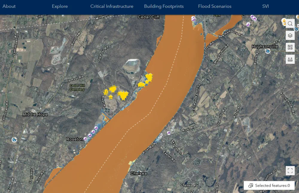
Bartın Üniversitesi (BARÜ) öncülüğünde iklim değişikliği üzerine 3 yıldır sürdürülen TÜBİTAK’ın desteklediği proje kapsamında, su kıtlığı ve arazi tahribatı haritası hazırlandı. Proje yürütücüsü BARÜ Orman Fakültesi Öğretim Üyesi Prof. Dr. Ayhan Ateşoğlu, “Haritaların bir sonraki aşamada özellikle iklim değişikliği temelinde, arazi ve arazi kullanımına yönelik farklılıklara da destek vereceğini söyleyebiliriz. Haritalar sadece ormancılık değil, tarım, ...
dha.com.tr
UAF Scientists To Hunt For Clues About Arctic Ocean Glaciation

UAF Scientists To Hunt For Clues About Arctic Ocean Glaciation

Evidence indicates a thick ice sheet, not annual sea ice and icebergs, covered the Arctic Ocean at some point during the last 140,000 years. Now, University of Alaska Fairbanks scientists will be looking for more geologic proof of the ice sheet’s existence, sources, behavior and extent. UAF Geophysical Institute scientists will focus on the Beaufort ...
kinyradio.com
Study Wildfire Spread Risk Increases Where Trees, Shrubs Replace Grasses

Study: Wildfire Spread Risk Increases Where Trees, Shrubs Replace Grasses

A new study, led by University of Florida forest management researcher Victoria Donovan, found that as woody plants like shrubs and trees replace herbaceous plants like grasses, spot fires can occur farther away from the original fire perimeter. This “woody encroachment” is not only a major issue in grasslands where the study takes place, but ...
eurekalert.org

CSIC Maps Mediterranean Seabed Via Satellite Images

Satellite-derived bathymetry continues to advance and improve rapidly. A recent scientific study has confirmed the effectiveness of a methodology developed to obtain bathymetric data from satellite images in the Western Mediterranean. The results of this research, published in the prestigious International Journal of Applied Earth Observation and Geoinformation, reaffirm the value of this tool for ...
miragenews.com
Mapping And AI Apps Suggest Ceasing Management Of Forests Not Enough To Offset Carbon Emissions

Mapping And AI Apps Suggest Ceasing Management Of Forests Not Enough To Offset Carbon Emissions

A team of atmospheric and climatic scientists from several institutions in Europe has found that even if all human management of forestry land stopped immediately, it would not be sufficient to offset global carbon emissions. In their study, reported in the journal Science, the group used mapping and AI applications to model how much forest ...
phys.org
El Ayuntamiento Renueva Su Portal De Visor Geográfico En Internet Con 49 Capas Geográficas De Información

El Ayuntamiento Renueva Su Portal De Visor Geográfico En Internet Con 49 Capas Geográficas De Información

El Ayuntamiento de Las Palmas de Gran Canaria, a través del área de Innovación Tecnológica, ha desplegado una nueva versión de su portal Geovisor, que dispone de una interfaz mejorada, moderna e intuitiva para acceder a través de internet a la información geográfica de interés que publica el consistorio. A través de dicho portal se ...
laspalmasgc.es

Nigeria Joins South Africa In Earth Observation Group

Nigeria on Wednesday joined South Africa to be the second country on the continent to be part of the Group on Earth Observations (GEO) GEO-Nigeria, for the promotion of access to data and information. The National Space Research and Development Agency (NASRDA) represents Nigeria at the global level. The group is an intergovernmental partnership that ...
gazettengr.com
Rainfall Extremes Are Becoming More Probable In Parts Of SA – UP Experts

Rainfall Extremes Are Becoming More Probable In Parts Of SA – UP Experts

Researchers at the University of Pretoria have found that the amount of rainfall in certain parts of South Africa has increased or become more extreme over the past 50 years or so. These investigations were part of a study led by Charlotte McBride of the South African Weather Service and a PhD candidate in UP’s ...
iol.co.za
3D “Digital Twin” Showcases Wreck Of Titanic In Unprecedented Detail

3D “Digital Twin” Showcases Wreck Of Titanic In Unprecedented Detail

The RMS Titanic sank to the bottom of the North Atlantic in 1912, but the fate of the ship and its passengers has fascinated the popular imagination for more than a century. Now we have the first full-size 3D digital scan of the complete wreckage—a “digital twin” that captures Titanic in unprecedented detail. Magellan Ltd, ...
arstechnica.com
Uconn Researchers Take A More Innovative Approach To Investigating Inequity In Parks

Uconn Researchers Take A More Innovative Approach To Investigating Inequity In Parks

‘While many studies looked at these topics at the city level, I was able to explore the local patterns within the city, not just talk about the fact that there is unequal access to parks, but I was able to identify neighborhoods that should be improved’. Not everyone has equal access to green spaces, and ...
today.uconn.edu
New Mapper Opens Up Access To Flood Planning In New York State

New Mapper Opens Up Access To Flood Planning In New York State

An accessible new mapping tool will make it easier for individuals and communities to plan for flooding and sea level rise. Developed by the NASA Socioeconomic Data and Applications Center (SEDAC) at Columbia Climate School’s CIESIN, the mapper visualizes spatial data for infrastructure across nearly all of New York State, except New York City. The ...
news.climate.columbia.edu
Pełny Obraz W Jednym Miejscu. Powiat Opolski Chce Mieć Cyfrową Ewidencję Dróg

Pełny Obraz W Jednym Miejscu. Powiat Opolski Chce Mieć Cyfrową Ewidencję Dróg

Dzięki cyfrowej bazie interweniujący czy planujący prace na trasach będą mieli szybki dostęp do pełnej informacji. Z drugiej strony będą tam trafiać wszystkie informacje o prowadzonych remontach, objazdach, także tych związanych z wypadkami. To będzie pierwsza taka baza danych o drogach w województwie – mówi Edyta Wenzel-Borkowska, naczelnik Wydziału Geodezji i Kartografii w Starostwie Powiatowym ...
radio.opole.pl
Cambrils Pone En Marcha Un Geoportal De Consulta Urbanística

Cambrils Pone En Marcha Un Geoportal De Consulta Urbanística

El Ayuntamiento de Cambrils ha puesto en marcha un Geoportal que permite a la ciudadanía consultar de manera más intuitiva y rápida los datos disponibles de los emplazamientos del municipio en referencia al planeamiento urbanístico, tanto municipal como supramunicipal. La nueva herramienta pone al alcance de toda la ciudadanía informaciones urbanísticas y cartográficas como la ...

Bayanat And Yahsat Announce Space Programme To Build Satellite Capabilities

Bayanat, a geospatial data products and services provider, and Abu Dhabi’s Al Yah Satellite Communications, better known as Yahsat, have launched a space programme aimed at building national satellite remote sensing and earth observation (EO) capabilities within the UAE. The space programme will look for business opportunities in the local and global EO market, Bayanat ...
thenationalnews.com