Geomaticians

05

Collecte De Données Satellitaires : Le Projet SenSpatial En Mode Décollage

En matière de données géospatiales, le Sénégal vise très haut. Les acteurs de l’écosystème, regroupés au sein du Groupe Interinstitutionnel de Coordination et de Concertation en Géomatique (GICC), ont tenu ce jeudi le premier Comité de Pilotage de lancement du projet SEN Spatial. Un projet ambitieux qui va permettre de poursuivre l’apprentissage pour faire du ...
seneweb.com

Scientists From Country’s Top Space Research Institutes Join Climate Change Deliberations At Kashmir University

Distinguished scientists from the country’s top research organisations involved in satellite earth observation including ISRO and other institutions of national importance joined deliberations on the use of satellite earth observation for climate services during a national-level workshop on ‘Earth Observations for Climate Services’ at the University of Kashmir on Thursday. Vice-Chancellor Prof Nilofer Khan inaugurated ...
greaterkashmir.com

Cispa-forscher Christoph Lenzen Erhält Erneut Proof Of Concept Grant Vom ERC

Der aktuelle Mobilfunkstandard 5G sowie das in der Entwicklung befindliche 6G versprechen immens schnelle Datenübertragungsraten und eröffnen damit ganz neue Möglichkeiten. Das in der Informatik altbekannte Problem, große verteilte Netzwerke zeitlich synchron zu halten, sorgt allerdings dafür, dass das volle Potenzial der neuen Technologien kaum ausgeschöpft werden kann. CISPA-Faculty Dr. Christoph Lenzen und sein Team ...
idw-online.de
Entwicklung Neuer Messtechniken In Der Geodäsie

Entwicklung Neuer Messtechniken In Der Geodäsie

Im EU-Forschungsprojekt „Large-scale dimensional measurements for geodesy“ (GeoMetre) entwickelten Forschende der Frankfurt University of Applied Sciences (Frankfurt UAS) und weiterer europäischer Wissenschaftsinstitutionen feldtaugliche Systeme und Analysestrategien zur Verbesserung der Genauigkeit und Rückführbarkeit geodätischer Längenmessungen. Das vom Forschungs- und Innovationsprogramm der Europäischen Union Horizon 2020 (18SIB01) geförderte Projekt verzeichnet schon Erfolge: Die neuen Messinstrumente und -techniken ...
innovations-report.de
Spacex Wyniesie Polskiego Satelitę. Start Już W Tym Roku

Spacex Wyniesie Polskiego Satelitę. Start Już W Tym Roku

W październiku br. będziemy świadkami wyniesienia w przestrzeń kosmiczną kolejnego satelity pochodzącego z Polski. Celem misji kosmicznej Intuition-1 jest wykonywanie zobrazowań Ziemi z wykorzystaniem satelity z instrumentem hiperspektralnym oraz zaawansowaną jednostką do przetwarzania danych na pokładzie opartej o głębokie sieci neuronowe w postaci komputera pokładowego – Leopard. Będzie to pierwszy na świecie satelita o mocy ...
space24.pl
Per Migliorare La Produzione Del Fotovoltaico Sul Tetto Arriva Il Catasto Solare 3D Di ENEA

Per Migliorare La Produzione Del Fotovoltaico Sul Tetto Arriva Il Catasto Solare 3D Di ENEA

Un potenziale incredibile non sfruttato, è quello rappresentato dalle coperture degli edifici nelle città italiane. Installare il fotovoltaico sul tetto potrebbe contribuire significativamente alla produzione energetica nazionale fornendo addirittura tra i 70 e i 90 GW di potenza complessiva. Per calcolare il potenziale di energia fotovoltaica installabile sui tetti e su ogni superficie urbana idonea, ...
rinnovabili.it
Realiza UNAM Monitoreo Satelital Permanente Para Detectar Incendios Forestales

Realiza UNAM Monitoreo Satelital Permanente Para Detectar Incendios Forestales

Ante el incremento de incendios forestales en nuestro país, el año pasado consumieron más de 730,000 hectáreas de bosques y selvas, investigadores del Instituto de Geografía (IGf) de la UNAM, realizan un monitoreo satelital permanente a través de un sistema automatizado de visualización para la detección de puntos de calor que permite alertar de forma ...
imagenagropecuaria.com
New Startup Nuview Targets Commercial Lidar Satellite Constellation

New Startup Nuview Targets Commercial Lidar Satellite Constellation

New geospatial satellite startup Nuview emerged from stealth mode on Thursday, with plans to build the first commercial LiDAR satellite constellation. A Nuview representative told Via Satellite the company aims to have a 20-satellite constellation, with tentative launch of the first satellites in 24 to 36 months. The company plans to launch satellites in groups ...
satellitetoday.com
Could AI Save The Amazon Rainforest

Could AI Save The Amazon Rainforest?

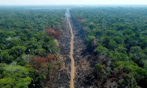
The tool, PrevisIA, is an artificial intelligence platform created by researchers at environmental nonprofit Imazon. Instead of trying to repair damage done by deforestation after the fact, they wanted to find a way to prevent it from happening at all. According to SAD, Imazon’s Deforestation Alert System, deforestation this March tripled compared to the same ...
theguardian.com