Geomaticians

March

From Tires To Brakes, U Of T Researchers Tackle ‘Non-tailpipe’ Air Pollution From Vehicles

From Tires To Brakes, U Of T Researchers Tackle ‘Non-tailpipe’ Air Pollution From Vehicles

While the push to mandate EVs aims to reduce tailpipe emissions such as carbon dioxide — the federal government has set a target of complete EV adoption by 2035 — swapping every vehicle on the road still won’t eliminate all the sources of air pollution that can impact human health. That’s because brake pads, rotors ...
news.engineering.utoronto.ca

Prepared Partners With NextNav On Vertical Location Intelligence

Prepared, the provider of mission-critical emergency multimedia services, has partnered with NextNav Pinnacle to power its z-axis location ecosystem. Prepared’s software currently enables 9-1-1 dispatch centers to livestream from the scene of an incident. It receives multimedia content, and pinpoint mobile callers’ location data to build real-time, big-picture assessments and improve overall emergency responses. Through ...

Alunos Da UFMG Criam Solução Para Detectar E Emitir Alertas De Desmatamento

Um grupo de alunos do Programa de Pós-graduação em Análise e Modelagem de Sistemas Ambientais, do Instituto de Geociência da Universidade Federal de Minas Gerais (IGC/UFMG), desenvolveu um programa capaz de detectar e emitir alertas de desmatamento usando, entre outras coisas, inteligência artificial e imagens de satélite. Chamado de TerraChange, a plataforma é um produto ...
em.com.br

Dresden Maps All Roofs In The City, To See If They’re Suitable For Solar

Last week, local authorities in Dresden, Germany, unveiled several new digital tools that would greatly help the city’s private residents adopt solar energy. Officials published two interactive maps of the city, one 3D and one flat, to give people an overview of the suitability of their houses for roof or façade photovoltaics. The maps were ...

인천시, 스마트 기술로 악취 저감

인천광역시는 올해 스마트 광역 종합관제센터 구축, 시료자동채취장치 확대 설치 등 3개 분야 11개사업, 130억원 규모의 악취 저감 사업을 추진한다고 15일 밝혔다. 악취 저감사업 3개 분야는 △사물인터넷(IoT) 기반 악취관리 체계 구축 △악취배출사업장 집중관리 △행정ㆍ재정적 지원을 통한 악취 저감사업이다. 올해는 스마트 광역 미세먼지ㆍ악취 종합관제센터 구축, 이동식 미세먼지ㆍ악취 시료 자동채취차량 제작 등 사물인터넷(IoT) 기반 악취관리 체계를 중점 추진할 ...
kgdm.co.kr

مسیریاب نشان، ویژگی‌های «ذخیره‌‌ باتری»، «پیاده‌روی» و «کنکاش» جدید را معرفی کرد

با فعال‌کردن «حالت ذخیره باتری»، برخی عملکردهای مسیریابی تغییر می‌کنند تا مصرف باتری کمتر شود. در یکی از مهم‌ترین تغییرات، سرعت دریافت GPS کاهش می‌یابد و به موازات این کاهش انیمیشن‌های مرتبط حرکت نرم نشان‌گر نیز خاموش می‌شوند. به‌این‌ترتیب نشانگر همچون گذشته روان و نرم حرکت نمی‌کند، اما در مقابل مصرف باتری کاهش پیدا خواهد ...
digiato.com

EagleView Unveils Geospatial Platform For Industries And Public Sector

EagleView Technologies, an aerial imagery, software, and analytics provider, is opening its platform for strategic customer and partner access. The EagleView Platform will provide customers and partners the capabilities to access interactive experiences, improve current workflows and create services and solutions with the same core capabilities and tools that power EagleView’s renowned products and services. ...
geospatialworld.net

Mach9 Launches High-speed Geospatial Production Software

The new product leverages artificial intelligence (AI) and computer vision to produce 2D and 3D CAD and GIS engineering deliverables faster than ever before, according to Mach9. This product launch comes amidst the company’s pivot to a software-first business model – a move driven by the rising demand for tools that accelerate geospatial data processing ...
gim-international.com

Esri GIS Helps Identify Gaps In Mental Health Service Provision

The Association of Mental Health Providers (AMHP) has created the first ever complete picture of mental health service provision across England, via a freely available interactive map, working in partnership with Esri UK. By combining data from the AMHP’s members and other mental health service providers, alongside demographic data, the map helps users understand where ...
directionsmag.com

China Launches 2nd Horus Remote-Sensing Satellite For Egypt

China has launched a second remote-sensing satellite for Egypt, just weeks after lofting the first in the series to orbit. A Long March 2C rocket lifted off from Jiuquan Satellite Launch Center in the Gobi Desert at 12:02 a.m. EDT on March 13 (0402 GMT, or 12:02 p.m. Beijing time). Orange exhaust pushed the rocket ...
space.com

Tracking Land Use And Deforestation In The Amazon

Scientists monitoring the region via satellite found that between 2000 and 2021, the average deforestation rate in nonprotected areas was about 14 times higher than in protected areas and Indigenous lands. The research contributes to an ongoing conversation about conservation of the Amazon, said study lead author Yuanwei Qin, a research scientist at the University ...
eos.org

IBGE Atualiza Lista Dos Municípios Utilizada Em Bases Geográficas E Estatísticas

O Instituto Brasileiro de Geografia e Estatística (IBGE) acaba de realizar mais uma atualização na lista de subdivisões municipais do país. Em relação ao ano anterior, o atual levantamento, referente a 2022, identificou o acréscimo de 28 novos distritos municipais, sendo 16 em Minas Gerais, 9 em Pernambuco, 1 no Amazonas, 1 em Rondônia e ...
mundogeo.com

Drones E Modelagem 3D Auxiliarão A Recuperação De Florestas

A popularização dos drones comerciais, das inteligências artificiais e dos softwares de modelagem 3D permitiram o desenvolvimento de um novo método para controlar áreas de reflorestamento. Durante seu doutorado no Instituto de Energia e Ambiente (IEE) da USP, o engenheiro florestal e pesquisador Rafael Walter de Albuquerque criou um procedimento mais rápido e capaz de ...
Indonesia, South Korea Strengthen Cooperation In Maritime Affairs

Indonesia, South Korea Strengthen Cooperation In Maritime Affairs

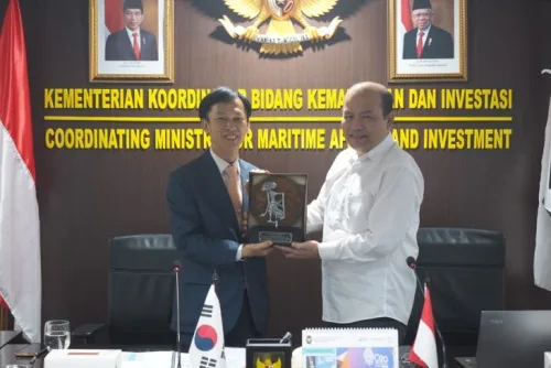
The Governments of Indonesia and South Korea held an annual Joint Commission meeting to intensify maritime and technological cooperation with discussions regarding climate change mitigation, blue economy, and marine aquaculture technology. Delegates that attended the meeting said that with the vast area of Indonesian waters, cooperation in the use of technology related to marine spatial ...
en.antaranews.com

WiMi Hologram Builds Intelligent Network System

WiMi Hologram Cloud, a Hologram Augmented Reality Technology provider, announced the construction of a holographic intelligent network system that integrates 6G and artificial intelligence technologies to promote holographic digital sensing, complete quantitative aggregation, refined control, smart execution, and integrated services in urban governance. The system can collect multi-source and multi-dimensional data, such as urban traffic ...
geospatialworld.net
Senzabarriere.App Arriva Ad Arezzo Al Via La Mappatura Dei Luoghi Pubblici

Senzabarriere.App Arriva Ad Arezzo: Al Via La Mappatura Dei Luoghi Pubblici

Una mappatura attenta e capillare del centro di Arezzo per comprendere, ed eventualmente migliorare, l’accessibilità dei luoghi pubblici della città. Grazie alla Fondazione Arezzo Comunità e al Comune di Arezzo arriva la Senzabarriere.app, un’applicazione che permette agli utenti di trovare i punti di interesse di un centro cittadino mostrandone il livello di accessibilità, rendendo così ...
arezzonotizie.it
Sevilla Presentará Su Estrategia Digital De Control De Sostenibilidad Turística Durante La Conferencia Esri De Andalucía

Sevilla Presentará Su Estrategia Digital De Control De Sostenibilidad Turística Durante La Conferencia Esri De Andalucía

Sevilla City Office, a través su Oficina de Turismo Inteligente (Smart Tourism Office), presentará el próximo 14 de marzo durante la Conferencia Esri de Andalucía su proyecto de Análisis de densidad y flujos turísticos, una de las iniciativas de digitalización del turismo más innovadoras de toda la Unión Europea, en la que han colaborado la ...
diariodesevilla.es

Cuidar Las Zonas Verdes Aplicando Tecnología Geoespacial E Inteligencia Artificial

Cuidar las zonas verdes aplicando tecnología geoespacial e inteligencia artificial ya es posible y Fuenlabrada será la primera ciudad de España en aplicar este innovador proyecto. A través de satélites y sensores, recopilan información más allá de la que se capta a simple vista proporcionando una completa y exhaustiva comprensión sobre lo que ocurre en ...
ondafuenlabrada.es
Phone-based Measurements Provide Fast, Accurate Information About The Health Of Forests

Phone-based Measurements Provide Fast, Accurate Information About The Health Of Forests

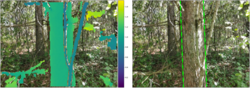
The researchers, from the University of Cambridge, developed the algorithm, which gives an accurate measurement of tree diameter, an important measurement used by scientists to monitor forest health and levels of carbon sequestration. “When you’re trying to figure out how much carbon a forest is sequestering, these ground-based measurements are hugely valuable, but also time-consuming,” ...
eurekalert.org
Lakes Can Change How Glaciers Move

Lakes Can Change How Glaciers Move

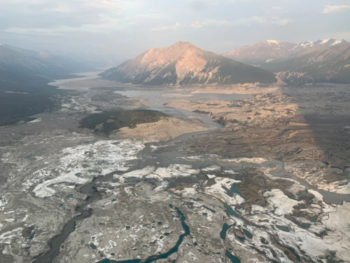
At the feet of mountain glaciers, melting ice forms pools of water that can be trapped behind moraines. And with warming temperatures, these pools are surging in both size and number. In Alaska and northwestern Canada, 183 new lakes appeared between 1984 and 2019, covering 483 square kilometers (190 square miles). New research showed that ...
eos.org

GeoComm And Esri Canada Collaborate On Indoor Mapping Capabilities For Better 9-1-1 Emergency Response

GeoComm, provider of Public Safety Location Intelligence®, and Esri Canada, a provider of geographic information system (GIS) solutions, have introduced a proof-of concept (PoC) solution that improves locating 9-1-1 callers inside buildings during an emergency event. The solution, unveiled at the Esri Partner Conference on March 6, 2023 in Palm Springs, California, aims to solve ...
directionsmag.com

Low-altitude Satellite Network To Be Launched For Better Remote Sensing

China Aerospace Science and Industry Corp, a major space contractor, is planning to deploy a remote-sensing satellite network in low-altitude orbits, according to a project leader. Song Xiaoming, president of the CASIC Second Academy, said that China intends to establish a space-based, high-performance infrastructure system for global remote-sensing operations. “To meet the urgent needs for ...
chinadaily.com.cn
Une Cartographie Des Sites D'aquaculture Sur Le Site Géolittoral

Une Cartographie Des Sites D’aquaculture Sur Le Site Géolittoral

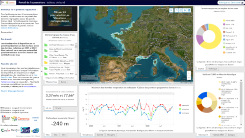
Le site Géolittoral s’enrichit d’une nouvelle rubrique qui donne accès à une cartographie et un tableau de bord des données sur les sites d’aquaculture et un visualiseur qui permet d’approfondir certaines thématiques. Elle a été développée à la demande de l’Etat par le Cerema, en collaboration avec les Centres techniques conchylicole (Capena, SMEL, Cepralmar, SMIDAP). ...
cerema.fr
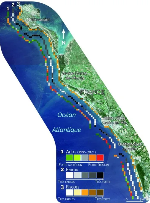
Les Données Satellitaires Au Service De La Gestion Des Littoraux Face Au Changement Climatique Bilan Du Programme Européen ‘ESA Coastal Erosion’ Mené Par I-sea

Les Données Satellitaires Au Service De La Gestion Des Littoraux Face Au Changement Climatique : Bilan Du Programme Européen ‘ESA Coastal Erosion’ Mené Par I-sea

Spécialisée dans la surveillance de la Biodiversité et du Littoral, l’entreprise bordelaise i-Sea est le chef de file de ESA Coastal Erosion, un programme européen de grande envergure initié en 2019 sous l’égide de l’ESA, l’Agence Spatiale Européenne. Basé sur l’observation satellitaire du littoral dans le but de prévenir et lutter contre le recul du ...
cdurable.info

Brasil E China Retomam A Parceria Para A Produção De Satélites

A Ministra da Ciência, Tecnologia e Inovação, Luciana Santos, confirmou nesta última terça-feira (28), anunciou que o Brasil quer começar a construção de um novo satélite do Programa de Satélites de Recursos Terrestres (CVBERS), com a China. De acordo com a ministra, a construção deve trazer de volta ao Brasil, o papel de protagonista perdido ...
diario24horas.com.br

NV5 Geospatial Begins Pilot Project To Analyze Climate Change For Caribbean Nations

NV5 Geospatial, North America’s most comprehensive geospatial science data firm, today announced that it will conduct aerial lidar and orthoimagery surveys across the Caribbean on behalf of the Caribbean Community Climate Change Centre (CCCCC). Funded by the Caribbean Development Bank (CDB), this pilot project will provide advanced geospatial data to help the island nations better ...
smartcitiesdive.com
Researchers To Explore Issues And Challenges To Suburban Densification

Researchers To Explore Issues And Challenges To Suburban Densification

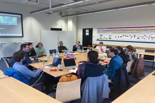
Researchers from the University of Liverpool are part of a new European project to explore the challenges, drivers and barriers of making suburban areas more populated. The SUBDENSE project, which involves TU Dortmund University, the Institut national de l’information géographique et forestière (IGN) and the IOER Leibniz Institute of Ecological Urban and Regional Development, was ...
news.liverpool.ac.uk
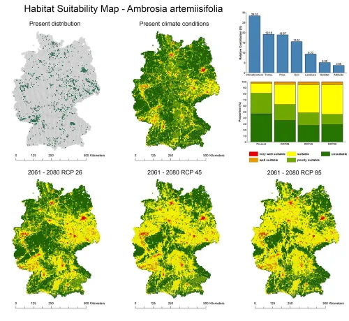
Invasive Plant Species Will Spread Even Further In Germany According To Simulation Study

Invasive Plant Species Will Spread Even Further In Germany According To Simulation Study

Many invasive plant species have not yet filled their potentially suitable habitat. This is what geographers at Leipzig University established in a recent simulation study. They coupled different data sets to predict the probability of occurrence of selected invasive plant species for any location in Germany. “Using satellite imagery to divide Germany into quadrants, I ...
phys.org
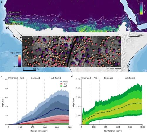
Tree Count In Africa Drylands Could Improve Conservation Study

Tree Count In Africa Drylands Could Improve Conservation: Study

A first count of trees in Africa’s drylands has enabled scientists to calculate how much carbon they store and could help devise better conservation strategies for the region and beyond, a study said Wednesday. The number of trees in the vast region—the count came to nearly 10 billion—has not been known up to now, and ...
phys.org

La Universidad De Alicante Acoge Un Congreso Internacional Sobre Geodesia

La Sede Universitaria Ciudad de Alicante de la Universidad de Alicante (UA), en su edificio de la calle San Fernando, acogerá desde el 1 al 3 de marzo un congreso internacional de Geodesia. Enmarcado en un grupo de trabajo específico del Servicio Internacional de Rotación terrestre y Sistemas de referencia (IERS), este encuentro recibirá a ...
elperiodic.com