Geomaticians

30

Satellogic Announces Integration With SkyFi

Satellogic Inc., a leader in sub-meter resolution Earth Observation (“EO”) data collection, today announced its partnership and integration with SkyFi, a leading provider of EO data. This partnership will allow SkyFi’s customers to task Satellogic satellites directly through the platform either at https://app.skyfi.com or on the SkyFi app. This capability is available to both businesses ...
spaceref.com

Des Chercheurs Suisses Se Lancent Dans Un Projet De Numérisation Pour Des Villes Durables En Afrique De L’ouest

À partir de septembre 2024, un groupe de recherche de l’École polytechnique fédérale de Lausanne se lancera dans le projet « Solutions numériques pour la ville durable en Afrique de l’Ouest » à Abidjan, en Côte d’Ivoire. L’initiative vise à numériser quatre villes de la sous-région, dont Abidjan, Bamako, Cotonou et Ouagadougou, et est cofinancée ...
afriqueitnews.com
광주시, 지적·공간정보 고정밀 구축에 드론 활용한다

광주시, 지적·공간정보 고정밀 구축에 드론 활용한다

광주시는 지난 2022년 6월 지적 확정 측량검사 및 3차원 공간정보 변화지역 갱신을 위해 정밀 측량용 드론을 도입, 지금까지 30개소 15㎢를 촬영했다. 촬영자료는 정사영상 제작 및 3차원 모델링 데이터로 구축, 경계 확인 및 3차원 공간정보 갱신자료로 활용되고 있다. 특히, 드론을 활용함으로써 약 1억원의 예산 절감 효과도 거뒀다. 광주시는 그동안의 운영 경험을 토대로 올해부터 부서 협업을 통해 ...
boannews.com
국토지리정보원, 국가기본도 고도화 추진…‘디지털 대한민국’ 앞당긴다

국토지리정보원, 국가기본도 고도화 추진…‘디지털 대한민국’ 앞당긴다

국가기본도가 다양한 공공·민간 데이터를 활용으로 최신성이 강화되고, 일관성 있는 데이터베이스로써 보다 폭넓은 분야와의 연계·활용이 가능해질 전망이다. 국토교통부 국토지리정보원은 29일 서울 영등포구 중소기업중앙회 K-Biz홀에서 ‘국가기본도 비전 선포식’을 개최했다고 밝혔다. 국토지리정보원에 따르면, 디지털 트윈 기술의 발전을 위해 지도의 최신성과 정확성이 강화되고 호환성이 향상돼야 한다는 요구가 커지고 있는 상황에서 자율주행이 가능하고 휠체어와 로봇이 자유롭게 이동할 수 있도록 현실 ...
cenews.kr
Politechnika Gdańska Kupiła Pojazd Do Pomiaru Stopnia Zużycia Dróg

Politechnika Gdańska Kupiła Pojazd Do Pomiaru Stopnia Zużycia Dróg

Politechnika Gdańska pozyskała samochód badawczy wyposażony w system laserowy umożliwiający zaawansowane pomiary stopnia zużycia nawierzchni drogowych, autostradowych oraz lotniskowych. Nowe narzędzie badawcze ma pomóc w opracowywaniu wytycznych dla zarządców dróg, które pozwolą ograniczyć remonty i związane z nimi utrudnienia w ruchu. System ten z dużą czułością i dokładnością potrafi wyłapać uszkodzenia na większości typów nawierzchni ...
gisplay.pl
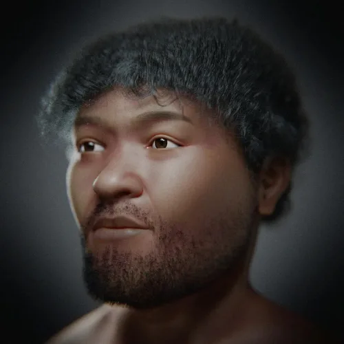
Brasileiros Recriam Rosto Do Homo Sapiens Mais Antigo Do Egito; Veja

Brasileiros Recriam Rosto Do “Homo Sapiens” Mais Antigo Do Egito; Veja

Uma dupla de pesquisadores brasileiros conseguiu reconstituir, a partir de técnicas de aproximação forense, o rosto de um fóssil com aproximadamente 35 mil anos de idade. O exemplar foi inicialmente descoberto em 1980, no Vale do Nilo, e é considerado como o Homo sapiens mais velho já registrado no Egito. “Esse fóssil passa por estudos ...
revistagalileu.globo.com

Brasil Teve O Território Expandido Em 2022, Aponta Levantamento Do IBGE

De acordo com levantamento divulgado pelo Instituto Brasileiro de Geografia e Estatística (IBGE), nesta quarta-feira (29/3), o Brasil aumentou os limites de seu território físico. Foram acrescentados aos domínios brasileiros 72,2 km², em 2022, o que fez o país passar de 8.510.345,540 km² para 8.510.417,771 km². A expansão geográfica se deve a edições de trechos ...
correiobraziliense.com.br

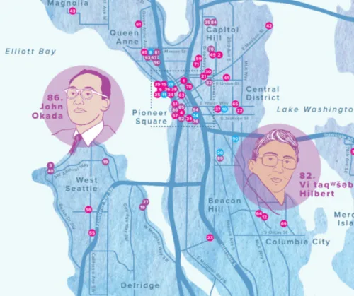
Seattle City Of Literature Debuts Map With Dozens Of South Ends Spots And Literary Heroes

Seattle City Of Literature Debuts Map With Dozens Of South Ends Spots And Literary Heroes

Last month Seattle City of Literature launched the Seattle Literary Map in print and digitally. The Literary Map is a guide to the people, places, businesses, and organizations that have made important contributions to Seattle’s literary scene. Seattle is one of only two UNESCO Cities of Literature in the United States. The Literary Map honors ...
‘A Network Of Belonging’ Meet The Woman Mapping Out The ’60s Scoop

‘A Network Of Belonging’: Meet The Woman Mapping Out The ’60s Scoop

Until she was in college, Colleen Cardinal thought she and her sisters were the only Indigenous people taken from their families at birth and adopted by a white family. Since learning she isn’t alone, Cardinal wants to make sure her story, and the stories of thousands of others, are heard. “I wanted to find all ...
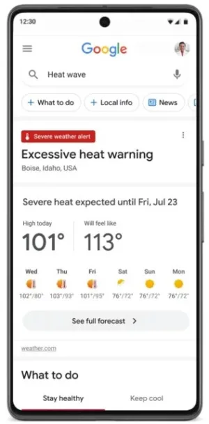
New Google Search Advisory Extreme Heat Alerts

New Google Search Advisory: Extreme Heat Alerts

Google has announced a series of measures to provide up-to-date and actionable information to help people and cities cope with rising temperatures due to climate change. These initiatives include new extreme heat alerts on Google Search, the expansion of the Tree Canopy tool for urban planning, and a $5 million investment in the World Resources ...
searchenginejournal.com
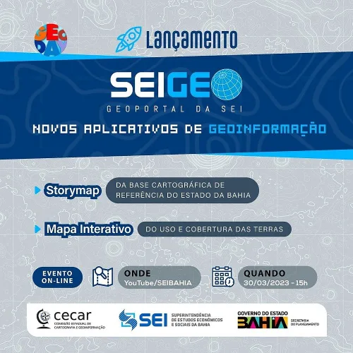
SEI Lança Novos Aplicativos De Geoinformação Em Evento On-line

SEI Lança Novos Aplicativos De Geoinformação Em Evento On-line

A plataforma SEIGEO, portal oficial de geoinformação da Superintendência de Estudos Econômicos e Sociais da Bahia (SEI), disponibiliza para os usuários dois novos aplicativos: o Storymap da Base Cartográfica de Referência do Estado da Bahia e o Mapa Interativo do Uso e Cobertura das Terras. As ferramentas serão lançadas em evento on-line, a ser realizado ...
correio24horas.com.br