Geomaticians

29

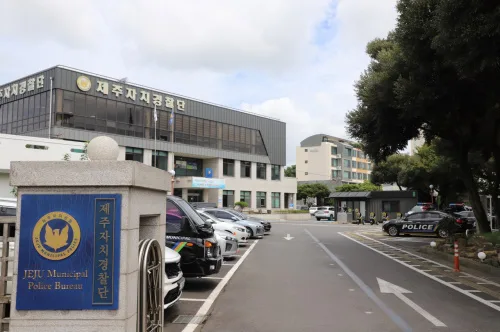
제주도, 교통통합플랫폼 연계 군중밀집도 분석 시스템 구축

제주도, 교통통합플랫폼 연계 군중밀집도 분석 시스템 구축

제주특별자치도 자치경찰단은 지난해 발생한 이태원 참사를 계기로 유동인구가 많은 제주시청 일대의 인파사고에 대비하고자 교통관제용 폐쇄회로텔레비전 (CCTV)을 활용한 ‘공간 군중밀집도 분석시스템’을 도내 최초로 구축할 계획이라고 27일 밝혔다. 올 상반기 중 도입할 공간 군중밀집도 분석 시스템은 현재 자치경찰단 교통정보센터에서 구축 중인 ‘제주형 교통통합 플랫폼’과 연계해 실시간 영상분석을 바탕으로 위험 발생 시 인근 도로안내 전광판 등에 위험상황을 알리는 ...
koit.co.kr

Investigadores Da Universidade De Évora Dão Contributos Para Planos De Gestão De Risco De Inundações!

Um dos pilares do Laboratório Associado CHANGE – Instituto para as Alterações Globais e Sustentabilidade, coordenado pelo MED, da Universidade de Évora, é a produção de conhecimento que apoie o desenvolvimento de políticas públicas inovadoras. Investigadores do MED, uma das unidades de investigação e desenvolvimento que constituem o CHANGE, desenvolveram um trabalho que foi tomado ...
radiocampanario.com
BİLSEM Öğrencilerinden Örnek Proje

BİLSEM Öğrencilerinden Örnek Proje

Yüksel Bahadır Alaylı Bilim ve Sanat Merkezi Öğrencileri “Konya Kitabelerinin Kültürel Kodları” projesi kapsamında Konya’nın tarihi yapıları ve bu yapılarda yer alan kitabeleri tanıtan web tabanlı coğrafi bilgi sistemi hazırladı. BİLSEM öğrencileri Fatih Dağ, Melis Akgöz ve Hilal Reyyan Konuk tarafından Tarih Öğretmeni Osman Kaynar danışmanlığında hazırlanan ve yürütülen projenin Konya’nın tarihi ve kültürel değerlerinin ...
yenikonya.com.tr
UP42 Expands Aerial Imagery And Geospatial Data Portfolio With Vexcel

UP42, the geospatial developer platform and marketplace, has significantly expanded its aerial imagery and elevation data portfolio through a partnership with Vexcel. The Vexcel Data Program delivers geospatial data products with high accuracy, spatial resolution, and consistency. Vexcel’s aerial data collection initiative is capturing ultra-high-resolution imagery (at 7.5 to 15cm resolution) and related geospatial data ...
.geospatialworld.net

Advanced Satellite Images Released To Public

The China National Space Administration published the first images taken by an advanced Chinese Earth-observation satellite on Tuesday afternoon. The 14 images were taken by the world-class apparatus on the Hyperspectral Multifunctional Observation Satellite, including a wide thermal infrared imager and an advanced hyper-spectral imager. They will help scientists track greenhouse gases such as nitrogen ...
chinadaily.com.cn
Water-Tracking Satellite Reveals First Views

Water-Tracking Satellite Reveals First Views

The international Surface Water and Ocean Topography (SWOT) mission—led by NASA and the Centre National d’Études Spatiales (CNES)—has sent back some of its first glimpses of water on the planet’s surface, showing ocean currents like the Gulf Stream in unprecedented detail. The spatial resolution of SWOT ocean measurements is 10 times greater than the composite ...
earthobservatory.nasa.gov
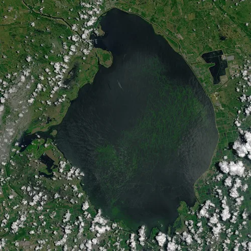
How A Florida Water District Uses Google Tools For Quality Management

How A Florida Water District Uses Google Tools For Quality Management

The South Florida Water Management District oversees water resources for more than 9 million residents, from Orlando to the Florida Keys. That means monitoring water quality, especially in Lake Okeechobee, the largest freshwater lake in the state and the 10th largest lake in the country. That’s no small task. In partnership with Google Public Sector, ...
statetechmagazine.com