Geomaticians

March

Planet Acquires Slovenian EO Company To Expand Data Platform

Planet, an Earth observation data and insights company, has announced its acquisition of Sinergise, a Slovenian cloud-based geospatial data platform provider. The acquisition aims to expand Planet’s data analysis platform, aiding the company to provide a more comprehensive set of geospatial data services to its customers. Planet aims to continue expanding into new vertical markets ...
geospatialworld.net

Texas Energy Company Recieves GPS Signals From Vialite Communications

The IT systems at CenterPoint Energy, Texas-based energy company have been given a boost and are now receiving high accuracy GPS timing signals over fiber optic links from ViaLite Communications. The RF over fiber connections enable the essential timing and synchronization signals to be sent over long distances without experiencing the attenuation inherent with coaxial ...
geospatialworld.net

Esri To Provide Malta Agencies With GIS Solutions

The Malta Information Technology Agency (MITA) has signed an enterprise agreement with Esri to enhance its GIS capabilities. The three-year agreement will provide Esri software, professional services and technical support to MITA and 22 other agencies across the Maltese government. Agencies such as health, communications and infrastructure organisations that do not currently benefit from enterprise ...
China Launches Wheel-like Constellation Of Remote-sensing Satellites

China Launches Wheel-like Constellation Of Remote-sensing Satellites

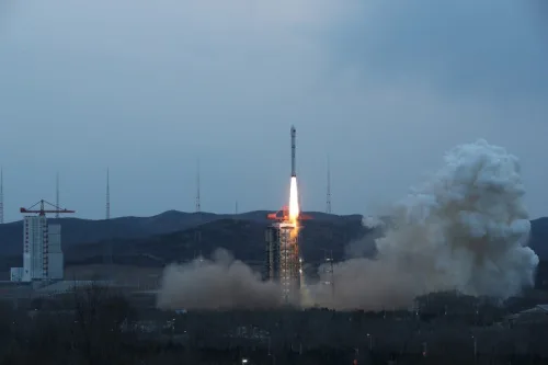
China launched a Long March-2D carrier rocket into space on Thursday evening carrying a wheel-like formation of four remote sensing satellites, the first formation of its kind in the world. The satellites of the PIESAT-1 constellation were launched at 6:50 p.m. (Beijing Time) from the Taiyuan Satellite Launch Center in northern China’s Shanxi Province, and ...
english.news.cn
Mapping Pedestrian Street Behavior Using Unmanned Aerial Vehicles

Mapping Pedestrian Street Behavior Using Unmanned Aerial Vehicles

A new study published in PLOS ONE tests the performance of UAV-based observation techniques in measuring pedestrian activity in two comparative settings in Santiago de Chile. Scientists developed an alternative approach of systematic behavioral observation of daily activities in the street based on the use of a UAV. They adapted the data acquisition techniques of ...
techexplorist.com

Satellogic Announces Integration With SkyFi

Satellogic Inc., a leader in sub-meter resolution Earth Observation (“EO”) data collection, today announced its partnership and integration with SkyFi, a leading provider of EO data. This partnership will allow SkyFi’s customers to task Satellogic satellites directly through the platform either at https://app.skyfi.com or on the SkyFi app. This capability is available to both businesses ...
spaceref.com

Des Chercheurs Suisses Se Lancent Dans Un Projet De Numérisation Pour Des Villes Durables En Afrique De L’ouest

À partir de septembre 2024, un groupe de recherche de l’École polytechnique fédérale de Lausanne se lancera dans le projet « Solutions numériques pour la ville durable en Afrique de l’Ouest » à Abidjan, en Côte d’Ivoire. L’initiative vise à numériser quatre villes de la sous-région, dont Abidjan, Bamako, Cotonou et Ouagadougou, et est cofinancée ...
afriqueitnews.com
광주시, 지적·공간정보 고정밀 구축에 드론 활용한다

광주시, 지적·공간정보 고정밀 구축에 드론 활용한다

광주시는 지난 2022년 6월 지적 확정 측량검사 및 3차원 공간정보 변화지역 갱신을 위해 정밀 측량용 드론을 도입, 지금까지 30개소 15㎢를 촬영했다. 촬영자료는 정사영상 제작 및 3차원 모델링 데이터로 구축, 경계 확인 및 3차원 공간정보 갱신자료로 활용되고 있다. 특히, 드론을 활용함으로써 약 1억원의 예산 절감 효과도 거뒀다. 광주시는 그동안의 운영 경험을 토대로 올해부터 부서 협업을 통해 ...
boannews.com
국토지리정보원, 국가기본도 고도화 추진…‘디지털 대한민국’ 앞당긴다

국토지리정보원, 국가기본도 고도화 추진…‘디지털 대한민국’ 앞당긴다

국가기본도가 다양한 공공·민간 데이터를 활용으로 최신성이 강화되고, 일관성 있는 데이터베이스로써 보다 폭넓은 분야와의 연계·활용이 가능해질 전망이다. 국토교통부 국토지리정보원은 29일 서울 영등포구 중소기업중앙회 K-Biz홀에서 ‘국가기본도 비전 선포식’을 개최했다고 밝혔다. 국토지리정보원에 따르면, 디지털 트윈 기술의 발전을 위해 지도의 최신성과 정확성이 강화되고 호환성이 향상돼야 한다는 요구가 커지고 있는 상황에서 자율주행이 가능하고 휠체어와 로봇이 자유롭게 이동할 수 있도록 현실 ...
cenews.kr
Politechnika Gdańska Kupiła Pojazd Do Pomiaru Stopnia Zużycia Dróg

Politechnika Gdańska Kupiła Pojazd Do Pomiaru Stopnia Zużycia Dróg

Politechnika Gdańska pozyskała samochód badawczy wyposażony w system laserowy umożliwiający zaawansowane pomiary stopnia zużycia nawierzchni drogowych, autostradowych oraz lotniskowych. Nowe narzędzie badawcze ma pomóc w opracowywaniu wytycznych dla zarządców dróg, które pozwolą ograniczyć remonty i związane z nimi utrudnienia w ruchu. System ten z dużą czułością i dokładnością potrafi wyłapać uszkodzenia na większości typów nawierzchni ...
gisplay.pl
Brasileiros Recriam Rosto Do Homo Sapiens Mais Antigo Do Egito; Veja

Brasileiros Recriam Rosto Do “Homo Sapiens” Mais Antigo Do Egito; Veja

Uma dupla de pesquisadores brasileiros conseguiu reconstituir, a partir de técnicas de aproximação forense, o rosto de um fóssil com aproximadamente 35 mil anos de idade. O exemplar foi inicialmente descoberto em 1980, no Vale do Nilo, e é considerado como o Homo sapiens mais velho já registrado no Egito. “Esse fóssil passa por estudos ...
revistagalileu.globo.com

Brasil Teve O Território Expandido Em 2022, Aponta Levantamento Do IBGE

De acordo com levantamento divulgado pelo Instituto Brasileiro de Geografia e Estatística (IBGE), nesta quarta-feira (29/3), o Brasil aumentou os limites de seu território físico. Foram acrescentados aos domínios brasileiros 72,2 km², em 2022, o que fez o país passar de 8.510.345,540 km² para 8.510.417,771 km². A expansão geográfica se deve a edições de trechos ...
correiobraziliense.com.br
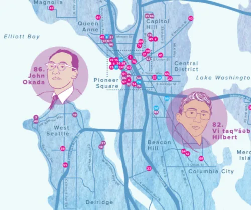
Seattle City Of Literature Debuts Map With Dozens Of South Ends Spots And Literary Heroes

Seattle City Of Literature Debuts Map With Dozens Of South Ends Spots And Literary Heroes

Last month Seattle City of Literature launched the Seattle Literary Map in print and digitally. The Literary Map is a guide to the people, places, businesses, and organizations that have made important contributions to Seattle’s literary scene. Seattle is one of only two UNESCO Cities of Literature in the United States. The Literary Map honors ...
‘A Network Of Belonging’ Meet The Woman Mapping Out The ’60s Scoop

‘A Network Of Belonging’: Meet The Woman Mapping Out The ’60s Scoop

Until she was in college, Colleen Cardinal thought she and her sisters were the only Indigenous people taken from their families at birth and adopted by a white family. Since learning she isn’t alone, Cardinal wants to make sure her story, and the stories of thousands of others, are heard. “I wanted to find all ...
New Google Search Advisory Extreme Heat Alerts

New Google Search Advisory: Extreme Heat Alerts

Google has announced a series of measures to provide up-to-date and actionable information to help people and cities cope with rising temperatures due to climate change. These initiatives include new extreme heat alerts on Google Search, the expansion of the Tree Canopy tool for urban planning, and a $5 million investment in the World Resources ...
searchenginejournal.com
제주도, 교통통합플랫폼 연계 군중밀집도 분석 시스템 구축

제주도, 교통통합플랫폼 연계 군중밀집도 분석 시스템 구축

제주특별자치도 자치경찰단은 지난해 발생한 이태원 참사를 계기로 유동인구가 많은 제주시청 일대의 인파사고에 대비하고자 교통관제용 폐쇄회로텔레비전 (CCTV)을 활용한 ‘공간 군중밀집도 분석시스템’을 도내 최초로 구축할 계획이라고 27일 밝혔다. 올 상반기 중 도입할 공간 군중밀집도 분석 시스템은 현재 자치경찰단 교통정보센터에서 구축 중인 ‘제주형 교통통합 플랫폼’과 연계해 실시간 영상분석을 바탕으로 위험 발생 시 인근 도로안내 전광판 등에 위험상황을 알리는 ...
koit.co.kr

Investigadores Da Universidade De Évora Dão Contributos Para Planos De Gestão De Risco De Inundações!

Um dos pilares do Laboratório Associado CHANGE – Instituto para as Alterações Globais e Sustentabilidade, coordenado pelo MED, da Universidade de Évora, é a produção de conhecimento que apoie o desenvolvimento de políticas públicas inovadoras. Investigadores do MED, uma das unidades de investigação e desenvolvimento que constituem o CHANGE, desenvolveram um trabalho que foi tomado ...
radiocampanario.com
BİLSEM Öğrencilerinden Örnek Proje

BİLSEM Öğrencilerinden Örnek Proje

Yüksel Bahadır Alaylı Bilim ve Sanat Merkezi Öğrencileri “Konya Kitabelerinin Kültürel Kodları” projesi kapsamında Konya’nın tarihi yapıları ve bu yapılarda yer alan kitabeleri tanıtan web tabanlı coğrafi bilgi sistemi hazırladı. BİLSEM öğrencileri Fatih Dağ, Melis Akgöz ve Hilal Reyyan Konuk tarafından Tarih Öğretmeni Osman Kaynar danışmanlığında hazırlanan ve yürütülen projenin Konya’nın tarihi ve kültürel değerlerinin ...
yenikonya.com.tr

UP42 Expands Aerial Imagery And Geospatial Data Portfolio With Vexcel

UP42, the geospatial developer platform and marketplace, has significantly expanded its aerial imagery and elevation data portfolio through a partnership with Vexcel. The Vexcel Data Program delivers geospatial data products with high accuracy, spatial resolution, and consistency. Vexcel’s aerial data collection initiative is capturing ultra-high-resolution imagery (at 7.5 to 15cm resolution) and related geospatial data ...
.geospatialworld.net

Advanced Satellite Images Released To Public

The China National Space Administration published the first images taken by an advanced Chinese Earth-observation satellite on Tuesday afternoon. The 14 images were taken by the world-class apparatus on the Hyperspectral Multifunctional Observation Satellite, including a wide thermal infrared imager and an advanced hyper-spectral imager. They will help scientists track greenhouse gases such as nitrogen ...
chinadaily.com.cn
Water-Tracking Satellite Reveals First Views

Water-Tracking Satellite Reveals First Views

The international Surface Water and Ocean Topography (SWOT) mission—led by NASA and the Centre National d’Études Spatiales (CNES)—has sent back some of its first glimpses of water on the planet’s surface, showing ocean currents like the Gulf Stream in unprecedented detail. The spatial resolution of SWOT ocean measurements is 10 times greater than the composite ...
earthobservatory.nasa.gov
How A Florida Water District Uses Google Tools For Quality Management

How A Florida Water District Uses Google Tools For Quality Management

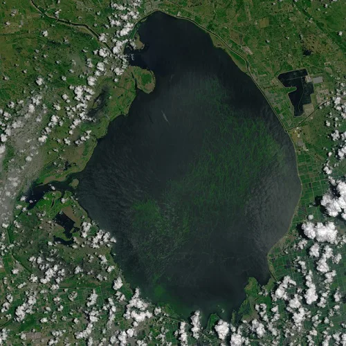
The South Florida Water Management District oversees water resources for more than 9 million residents, from Orlando to the Florida Keys. That means monitoring water quality, especially in Lake Okeechobee, the largest freshwater lake in the state and the 10th largest lake in the country. That’s no small task. In partnership with Google Public Sector, ...
statetechmagazine.com
땅 속 보이지 않는 파이프···3D로 생생하게 보다

땅 속 보이지 않는 파이프···3D로 생생하게 보다

복잡하게 매설되어 있는 파이프는 때때로 문제의 원인이 되기도 한다. 건물 건설에 앞서 지하기반 공사 과정에서 예상과 다른 파이프 위치로 인해 설계가 달라지거나, 혹은 파이프를 건드려 파손사고가 일어나는 경우가 있다. ‘파이프는 망가져야 고친다’라는 말처럼 파이프에 대한 정확한 정보의 부재로 인해 항상 사고가 터지고 사후 수습을 하는 형태. 이러한 문제점을 해결하기 위해 무브먼츠는 파이프를 3D 모델로 지상으로 ...
서울시립대-이지스 “산학 협력, 디지털 트윈 이끈다”

서울시립대-이지스 “산학 협력, 디지털 트윈 이끈다”

3차원 지리공간정보(GIS) 전문기업 이지스(대표 김성호)는 서울시립대와 최근 본교 21세기관 회의실에서 ‘디지털트윈 클라우드 교육 서비스 협력’을 위한 계약을 맺었다고 27일 밝혔다. 이지스는 이번 계약을 통해 지리 공간정보 기반 디지털트윈 클라우드 구독서비스 30개 계정을 교육용으로 제공하기로 했다. 이와 함께 교육·기술적 지원도 제공할 예정이다. 특히 영상, 드론, 라이다, 센서 데이터, 2D·3D 공간정보, 다양한 속성정보 등을 클라우드 플랫폼 상에서 ...

Smart City. Uno Scanner Laser Per Costruire Il Gemello Digitale Di Milano, Al Via Fase Di Test

Uno scanner laser sul tetto di un veicolo del Comune che scatta fotografie ad alta frequenza per produrre una ricostruzione digitale del territorio. I milanesi e le milanesi lo vedranno circolare da oggi fino al 7 aprile in alcune zone della città, in particolare quelle interessate dai grandi cantieri (ad esempio le aree degli ex ...

La Nueva Constelación De Satélites IRIDE Para Vigilar Italia Y Europa, Será Construida Por Thales Alenia Space

Con los contratos obtenidos de la ESA, Thales Alenia Space suministrará un primer lote de seis pequeños satélites con radar de apertura sintética (SAR) y un satélite basado en tecnología óptica para la constelación italiana de observación de la Tierra, IRIDE. Los satélites se construirán en Italia bajo la responsabilidad de Thales Alenia Space y ...
hispaviacion.es

Govt To Introduce GPS-based Toll System In Six Months

The Indian government has announced plans to implement a GPS-based toll system within the next six months, which will replace traditional toll plazas, said Union minister Nitin Gadkari. This new system will rely on GPS technology to track and charge vehicles as they use highways and other roads, eliminating the need for physical toll booths ...
Türkiye Maps Northwestern Forest Migration Amid Climate Change

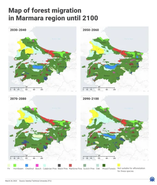
Türkiye Maps Northwestern Forest Migration Amid Climate Change

Türkiye on Friday released a map of the projected distribution of trees and the migration of forests around the country’s internal Marmara Sea until the end of this century. The initiative was part of a project carried out to explore the potential of the northwestern forests in the Marmara region to adapt to climate change. ...
aa.com.tr

Mapping The Risks Of Isolation Due To Sea Level Rise Associated With Global Warming

A trio of environmental engineers, two with the University of Canterbury in New Zealand, the third with the University of Maryland, has developed a way to illustrate the impact of sea level rise isolation associated with global warming. In their paper published in Nature Climate Change, Tom Logan, M. J. Anderson and Allison Reilly describe ...
phys.org

Indian Space Startup Pixxel Bags US Contract For Hyperspectral Imagery

Bengaluru-based space startup Pixxel has bagged a five-year contract for supplying technical hyperspectral imagery to United States’ National Reconnaissance Organization (NRO). Pixxel will provide technical hyperspectral imagery (HSI) remote sensing capabilities through modelling and simulation and data evaluation using its currently on-orbit pathfinder systems and future constellations. Last year, Pixxel had launched its hyper-spectral imaging ...
newsdrum.in