Geomaticians

21

RSA And Esri Sign MoU To Boost Geospatial Services For Rwanda’s Social-Economic Development

The CEO of the Rwanda Space Agency (RSA), Colonel Francis Ngabo, and the President of Esri, Jack Dangermond, signed a Memorandum of Understanding (MoU) to establish a collaborative partnership, setting the foundation for promoting geospatial services to drive social-economic development in Rwanda. The momentous event occurred on the sidelines of the 2023 Esri User Conference ...
africanews.space

Australia’s SmartSat Signs Agreement To Collaborate On Earth Observation

SmartSat Cooperative Research Centre (SmartSat), Australia’s space research centre, has signed a new agreement with European Space Agencys (ESA) Philab to collaborate on Earth Observation (EO) research. The European Space Agency’s Philab is a leading research centre with a mission to accelerate the future of Earth Observation through transformational innovations and new technologies, including artificial ...
itbrief.com.au

Ohla Empleará Gemelos Digitales GIS Y Tecnología De Drones En Un Proyecto Viario En Cáceres

Ohla ha iniciado las obras de construcción de la variante de Malpartida en la provincia de Cáceres (Extremadura), un proyecto adjudicado por el Ministerio de Transportes, Movilidad y Agenda Urbana (Mitma) por cerca de 45 millones de euros. Se trata de una de las primeras obras del Ministerio en la que se emplearán metodología BIM ...
interempresas.net

New Online App Launches To Map Out Public Art Across Fairfax County

ArtsFairfax wants you to help it keep track of all the public art popping up around Fairfax County. The county’s designated, nonprofit local arts agency recently launched an online Public Arts Locator to identify and map out murals, sculptures and other installations placed in the community, either permanently or on a temporary basis. The app ...
ffxnow.com

Stadt Bern Stellt Geodaten Der Öffentlichkeit Zur Verfügung

Wo darf mit welcher Parkkarte parkiert werden? Wo ist das Bauen aufgrund von Naturgefahren eingeschränkt? Die Stadt Bern nutzt als Grundlage für ihr Handeln eine Vielzahl von Geodatensätzen. Neu stellt sie diese Daten über das städtische Geoportal www.bern.ch/geoportal auch der Öffentlichkeit zur Verfügung. Die Stadt Bern macht einen weiteren Schritt in Richtung digitale Verwaltung und ...
bern.ch

Washington View: FCC Again Urged To Aid Satellite Precision Agriculture

Recent bipartisan legislation aims to make satellite communication and PNT services more available to farmers. Legislation that nudges the Federal Communications Commission (FCC) to do more to make satellite communication and PNT services available to rural America, particularly farmers, has sailed through the House and is awaiting committee action in the Senate. The bipartisan legislation—something ...
insidegnss.com

New Online ‘Forest Eye’ Will Daylight Old-Growth Logging In B.C.

An online tracking system developed by an international environmental group goes live today. It will enable the public to monitor where old growth is being logged and is designed to hold the province accountable for promises to reform forestry, said project lead Angeline Robertson, a senior investigative researcher with Stand.earth. Forest Eye — an online ...
nationalobserver.com
Better Synthesis Of Geospatial Data May Help Combat Poachers, Scientists Say

Better Synthesis Of Geospatial Data May Help Combat Poachers, Scientists Say

Poaching wild animals poses global environmental risks, from threatening the survival of keystones species to potentially spreading animal-borne diseases to humans. Technology like unmanned aerial vehicles, or drones, can help combat poachers, but finding the best way to use the large amounts of geospatial data generated by these tools remains a challenge, according to Penn ...
psu.edu
Un Proyecto Español Permitirá Saber Qué Árboles Plantar En Función Del Cambio Climático

Un Proyecto Español Permitirá Saber Qué Árboles Plantar En Función Del Cambio Climático

El pasado mes de mayo se dio el pistoletazo de salida al proyecto ForesteCCo (FORtaleciendo la RESTauración Ecológica y la infraestructura verde para la adaptación de especies forestales al Cambio ClimáticO). Este proyecto de investigación e innovación se desarrolla con el apoyo de La Fundación Biodiversidad del Ministerio para la Transición Ecológica y el Reto ...
elplural.com
Global GPS Measurements Indicate Observable Phase Of Fault Slip Two Hours Before Large Earthquakes

Global GPS Measurements Indicate Observable Phase Of Fault Slip Two Hours Before Large Earthquakes

Analysis of Global Positioning System (GPS) time-series data from nearly 100 large earthquakes worldwide has provided evidence for the existence of a precursory phase of fault slip occurring two hours before seismic rupture. “If it can be confirmed that earthquake nucleation often involves an hours-long precursory phase, and the means can be developed to reliably ...
eurekalert.org
New Wave Of Satellite Tech Can Help Protect Against Ocean Overfishing

New Wave Of Satellite Tech Can Help Protect Against Ocean Overfishing

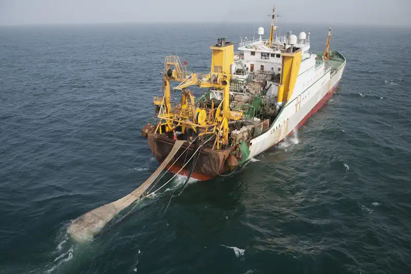
Around one-third of fish stocks worldwide are overfished, while 20 percent of all seafood is obtained through illegal, unreported, and unregulated fishing. Most such fishing, known as IUU, occurs on the high seas, where the governance of marine areas is tricky and their protection is virtually non-existent. IUU fishing vessels pursuing the largest profits often ...
earthisland.org