Geomaticians

20

I Kongres Geoinformacyjny: Zmiana Terminu Zgłaszania Referatów

Do 23 września został wydłużony termin, w którym można zgłaszać referaty na I Kongres Geoinformacyjny. Wydarzenie odbędzie się w dniach 25–27 października w Krakowie. Jak zapewniają organizatorzy, spotkanie pozwoli na pełną integrację środowisk związanych z geoinformacją w kraju, ale nie tylko. Kongres Geoinformacyjny będzie wydarzeniem naukowym, które umożliwi prezentację najnowszych polskich i zagranicznych osiągnięć badawczych ...
geoforum.pl

Ruszyły Zapisy Na VIII Forum Biogis

Można już zapisywać się na VIII Forum BioGIS – System Informacji Przestrzennej w badaniach różnorodności biologicznej, które odbędzie się w dniach 29 – 30 listopada 2023 r. w Poznaniu. Forum BioGIS jest cykliczną imprezą o charakterze konferencji i warsztatów, której głównym celem jest wymiana doświadczeń między nauką i praktyką, a także popularyzacja wiedzy na temat ...
gisplay.pl

Veridaas Corporation And Tarin Resource Services Join Forces To Revolutionize Geospatial Data Solutions

VeriDaaS Corporation, a leading provider of high-quality geospatial data, and Tarin Resource Services, a prominent name in the Canadian geospatial industry, are thrilled to announce their strategic partnership. Under this new agreement, Tarin Resource Services has become an official reseller of VeriDaaS data, opening doors to unparalleled geospatial solutions for clients across various industries. The ...
directionsmag.com

WSA Announces Launch Of GeoHub Portal

The Water Security Agency of Saskatchewan (WSA) announced the launch of its GeoHub portal, making data used by the agency to monitor and manage the province’s water resources freely available for the public. The new WSA GeoHub brings together 17 Geographic Information System (GIS) layers and four web maps in one place. This open-data portal ...
saskatchewan.ca

Una Mappa “Digitale” Della Lettura In Città: Al Via Un Questionario Online Per La Ricognizione

Una mappa per rendere i luoghi della lettura di Firenze visibili e accessibili, questo è il progetto che il Comune di Firenze attraverso le Biblioteche Comunali Fiorentine sta disegnando. La mappa raccoglierà sia i luoghi della lettura più conosciuti, ma anche quelli più insoliti, in cui la lettura è presente come veicolo di socialità e ...
comune.fi.it

Introducing The Digital Atlas: Unlocking The Power Of Location-Based Data

In an exciting step forward in how we access and use location data, the Digital Atlas of Australia beta was released to the public on 30 June 2023. The interactive, secure, and easy-to-use platform brings together, curates and connects trusted data from across government. Anyone, anywhere can explore, analyse and visualise data on Australia’s geography, ...
ga.gov.au
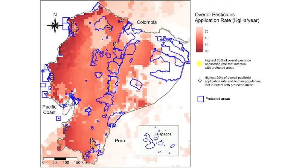
Mapping Intersections Of Pesticides, Protected Areas, And People

Mapping Intersections Of Pesticides, Protected Areas, And People

Agricultural pesticide use has resulted in increased quantity and quality of produced foodstuffs, but at a cost—these pesticides can have negative, and not fully understood, impacts on human and ecosystem health. Some pesticide application techniques can result in product being transported away from the farm fields and onto proximal locations, causing concerns about exposures should ...
eos.org