Geomaticians

27

El IDAE Publica El Mapa De Comunidades Energéticas Con Los Primeros 43 Proyecto

El IDAE Publica El Mapa De Comunidades Energéticas Con Los Primeros 43 Proyectos

La primera fase del mapa de comunidades energéticas del programa CE Implementa, con los primeros 43 proyectos, se ha publicado en el apartado de comunidades energéticas de la web del Instituto para la Diversificación y Ahorro de la Energía (IDAE), dependiente del Ministerio para la Transición Ecológica y el Reto Demográfico (Miteco). El objetivo de ...
smartgridsinfo.es
Angola Launches The Drought Decision Support Projec

Angola Launches The Drought Decision Support Project

On 26 January 2023, the Ministry of Telecommunications, Information Technologies and Social Communications (MINTTICS), the National Space Programme Management Office (GGPEN), in collaboration with the Massachusetts Institute of Technology (MIT), and the Space Enabled Research Group of the MIT Media Lab, inaugurated the “Support System for Policies to Combat Drought in Southern Angola” project. The ...
africanews.space
Hexagon Announces New Platform For Defense Mobile App

Hexagon Announces New Platform For Defense Mobile Apps

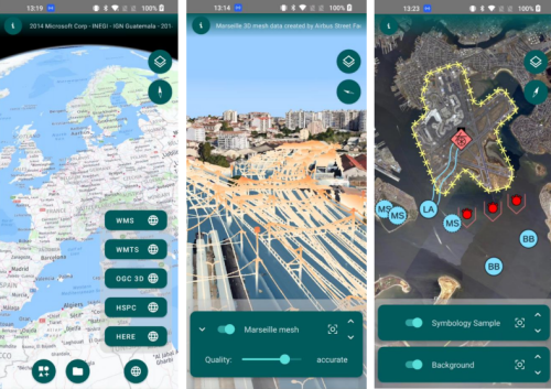
Hexagon’s Safety, Infrastructure & Geospatial division has introduced LuciadCPillar for Android, a platform for developing mobile applications for dismounted soldiers in the field. The new Android platform enables developers to build applications with 2D/3D views, featuring military symbology and supporting many geospatial data types, including vector data, raster data, elevation data, point clouds and 3D ...
directionsmag.com
Airborne Surveys Launched In Chile To Detect Sources Of Methan

Airborne Surveys Launched In Chile To Detect Sources Of Methane

Airborne surveys have been launched in Chile to detect sources of methane by Carbon Mapper, a California based nonprofit. This survey aims to point sources that potentially emit disproportionately high volumes of methane and therefore offer important mitigation opportunities. This survey kicks off a broader initiative to conduct airborne methane surveys in the Latin American ...
geospatialworld.net