Geomaticians

18

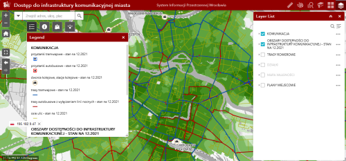
Wrocław Udostępnił Mapę Dostępności Komunikacyjnej

Wrocław Udostępnił Mapę Dostępności Komunikacyjnej

Dobra komunikacja i sprawne przemieszczanie po mieście często decydują o jakości życia. Wrocław twierdzi, że jako pierwsze miasto w Polsce ocenił dostępność komunikacyjną w zależności od lokalizacji. Mapa dostępności komunikacyjnej nazwana też „zielonym pająkiem Wrocławia” od wtorku 17 stycznia dostępna jest dla każdego. Wyniki analizy poznać mogą zarówno mieszkańcy jak i inwestorzy. Mapa wykonana została ...
portalsamorzadowy.pl
New Trimble Forestry Lab At The University Of British Columbia

New Trimble Forestry Lab At The University Of British Columbia

Trimble is working with the University of British Columbia (UBC) to establish a state-of-the-art Trimble Technology Lab at UBC’s Forest Sciences Center. UBC is a global center for teaching, learning and research, consistently ranked among the top 20 public universities in the world. The new lab at UBC will be the first forestry-focused lab for ...
insidegnss.com

Bowman’s Geospatial Division Delivers Advanced Lidar Ceiling Scanning Techniques To Cuhaci Peterson To Enable Commercial Design Efficiency

Interior scanning of structures that have ceiling tiles, like grocery stores, presents a challenge for efficiency and accuracy for surveyors. Bowman took on this challenge to develop a new and proven technique that is simple, elegant, accurate, and most of all, repeatable in other environments. Prior to developing this technique, ground level 3-D scanning in ...
businesswire.com
New Software To Help With Schenectady Police Patrol Coverage, Give Officers Real-time Street Updates

New Software To Help With Schenectady Police Patrol Coverage, Give Officers Real-time Street Updates

An innovative software program will allow Schenectady police officers to track which streets have been patrolled in the city with real-time updates, the city announced on Tuesday. The new Patrolfinder software was produced by the Transfinder school bus-routing company in partnership with the Schenectady Police Department. The software, which will be deployed in all department ...
dailygazette.com
SkyFi Launches Satellite Imagery App

SkyFi Launches Satellite Imagery App

SkyFi believes that satellite imagery should be easily accessible and affordable for anyone to access. Today, the Austin, TX startup took a major step toward democratizing that data with the public launch of its mobile and web apps. The story so far: SkyFi built an entirely new app and interface for individuals to task satellites ...
payloadspace.com
Hexagon And Ness Provide Digital Maps For Czech Railways

Hexagon And Ness Provide Digital Maps For Czech Railways

Ness Czech will supply the Czech Railway Administration with a Digital Technical Railway Map (DTRM) with help from Hexagon’s Safety, Infrastructure and Geospatial division. The DTRM project has been underway since September 2022 and will be implemented by 2025. DTRM is a railway-specific geographic information system (GIS), that provides access to transport and technical infrastructure ...
b2bchief.com
Spacex Is Reducing Starlink's Impact On Astronom

Spacex Is Reducing Starlink’s Impact On Astronomy

NSF has outlined a new agreement it signed with SpaceX to protect ground-based astronomy covering the brightness of Starlink satellites, competing usage of radio bands, and finding ways to ensure Starlink’s orbital information is publicly available so astronomers can schedule observations around satellite locations. SpaceX has agreed to coordinate with impacted US radio astronomy facilities. ...
zdnet.com
China Launch Plans More Than 70 Launches In 202

China Launch Plans More Than 70 Launches In 2023

China’s state-owned and commercial space sector actors are planning a total of more than 70 launches across 2023 as the country’s space activities continue to expand. The China Aerospace Science and Technology Corporation (CASC), the country’s main space contractor and maker of the Long March rocket series, will again aim for more than 50 launches ...
spacenews.com
Esri India UC 2023 Marches Ahead To Transform Communities Through GIS

Esri India UC 2023 Marches Ahead To Transform Communities Through GIS

Esri India, India’s one of the leading Geographic Information System (GIS) solutions provider, is back with its flagship conference, Esri India User conference (UC) in-person this year. The theme of this year’s conference is ‘GIS — Transforming Communities’. The conference is scheduled to be held on January 18, 2023 in Delhi and on January 20, ...
geospatialworld.net

Synspective And Insight Terra Announce Space-enabled Data And Monitoring Solution For Mine Tailings Facilities

Synspective, a Tokyo based SAR (synthetic aperture radar) satellite data and solutions provider, and Insight Terra, a London based start-up providing a cloud based environmental and infrastructure risk management platform and solutions, have entered into a strategic partnership to deliver a new space enabled data and monitoring solution for the mining industry. The solution uses ...
realwire.com