Geomaticians

17

IBGE Usa Plataforma Geográfica Interativa Para Monitoramento Da Coleta Do Censo 2022

IBGE Usa Plataforma Geográfica Interativa Para Monitoramento Da Coleta Do Censo 2022

A Plataforma Geográfica Interativa (PGI), usada nas divulgações de produtos de geociências do IBGE, também está sendo utilizada para o acompanhamento dos recenseadores do Censo 2022. Com ela, o Instituto pode verificar a situação da coleta por cada setor em um mapa interativo. Na última sexta-feira (13), um seminário interno para os técnicos do IBGE ...
idest.com.br
Este Nuevo Mapa De Protección Civil Te Informa De Las Alertas Que Hay En Tu Zona En Tiempo Real Lluvias Torrenciales Y Más

Este Nuevo Mapa De Protección Civil Te Informa De Las Alertas Que Hay En Tu Zona En Tiempo Real: Lluvias Torrenciales Y Más

Esta nueva herramienta da visibilidad a la Red de Alerta Nacional (RAN) a través de un visor que se encuentra en una página web accesible desde un ordenador o un dispositivo móvil. Al momento de abrir la página se verá un mapa de toda España con todas las alertas que haya activas en ese momento ...
genbeta.com
“Geospatial Hackathon” Launched To Encourage Innovation And Start-ups In Indi

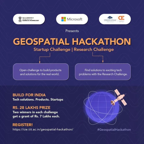
“Geospatial Hackathon” Launched To Encourage Innovation And Start-ups In India

Dr. Jitendra Singh, the Union Minister for Science and Technology, launched the Geospatial Hackathon to encourage innovation and start-ups in India’s geospatial ecosystem. Speaking at the event in New Delhi, Dr. Singh stated that the hackathon’s goal was to encourage collaborations between the public and private geospatial sectors as well as to develop the nation’s ...
currentaffairs.adda247.com

European Space Agency Backs Geospatial Project To Protect Utilities

MGISS, a UK geospatial company, aims to understand how satellite imagery can identify areas where developments could disrupt gas and water supply. The Interruption Prevention Alert Service project will use satellite data and services to automatically detect changes to the built environment in order to prevent outages in critical utilities. The company argued that a ...
placetech.net
Lidar Survey Of New Zealand’s Taranaki Regio

Lidar Survey Of New Zealand’s Taranaki Region

A ground-breaking aerial LiDAR survey of Taranaki’s land surface has just been completed, opening up a wealth of valuable land-surface and elevation data for a wide range of uses. The dataset — collected in 2021 and two years in the making — will be used to generate high-definition 3D maps and models for environmental management ...
spatialsource.com.au