Geomaticians

February

Ortofotomapa Dla Blisko 25 Tys. Km Kw. Już W Geoportalu

Ortofotomapa Dla Blisko 25 Tys. Km Kw. Już W Geoportalu

Aktualizacja objęła ortofotomapę w rozdzielczości 25 cm pokrywającą łącznie 24 528 km kw. w województwach: warmińsko-mazurskim, mazowieckim, świętokrzyskim i podkarpackim. Szczegółowy zasięg nowych materiałów prezentuje mapa obok. Są to już kolejne dane, jakie trafiły w tym roku do zasobu geodezyjnego w efekcie realizacji kontraktu na ortofotomapę całego kraju zleconego przez Agencję Restrukturyzacji i Modernizacji Rolnictwa. ...
geoforum.pl

Esri Unterzeichnet Vereinbarung Mit Malta Über Zugang Zu Gis-technologie Und Schulungen

MITA hat eine Vereinbarung mit Esri unterzeichnet, dem weltweiten Marktführer im Bereich Location Intelligence, um die Fähigkeiten der MITA bei geografischen Informationssystemen (GIS) zu erweitern. Der Dreijahresvertrag beinhaltet die Bereitstellung von Esri-Software, professionellen Dienstleistungen und technischem Support für MITA und 22 weitere Behörden der maltesischen Regierung. Im Rahmen der Vereinbarung werden die bestehenden GIS-Anwender in ...
boerse.de
Rencontre Aérospatiale Au Sommet À Casablanca

Rencontre Aérospatiale Au Sommet À Casablanca

La première édition de l’Aerospace African Forum s’est ouvert ce matin à Casablanca, la capitale économique du Maroc et la plus grande ville du Maghreb. L’événement est organisé comme une plateforme continentale de réflexion sur le thème de la mobilité durable, est organisé par l’Africa Air Forum et le Gimas (Groupement des industries marocaines aéronautiques ...
air-cosmos.com

Bilim Insanları Afet Bölgesinin Röntgenini Çekiyor! Belirlenen Noktalara GPS Cihazları Ve Sabit Istasyon Kurulacak

7.7‘lik büyük felaket sonrası TÜBİTAK’ın çağrısıyla afet bölgesine çıkarma yapan bilim insanları, 10 ilin röntgenini çekiyor. Fay hareketlerinin nasıl değiştiğini gözlemleyebilmek amacıyla bölgeye 3 ekibini gönderen Boğaziçi Üniversitesi Kandilli Rasathanesi Jeodezi Anabilim Dalı öğretim üyesi Prof. Dr. Semih Ergintav, “Belirlenen noktalara GPS cihazları ve sabit istasyon kuracağız. Amacımız bundan sonraki nesillere fay hareketliliği ile ilgili ...
sabah.com.tr
Geoportal Nova Ferramenta Orienta Interessados Em Obter Licenciamento Ambiental No Amazonas

Geoportal: Nova Ferramenta Orienta Interessados Em Obter Licenciamento Ambiental No Amazonas

O Instituto de Proteção Ambiental do Amazonas (Ipaam) lançou uma ferramenta de consulta que fortalecerá o licenciamento ambiental no Estado do Amazonas, o Geoportal. A ferramenta é um repositório de dados espaciais e não espaciais de agendas temáticas ligadas às atividades de licenciamento, fiscalização e monitoramento ambiental, que visa oferecer à sociedade maior facilidade no ...
portalamazonia.com
La ESA Firmó Un Acuerdo De Cooperación Con México

La ESA Firmó Un Acuerdo De Cooperación Con México

La ESA y la Agencia Espacial Mexicana (AEM) han firmado un Acuerdo de Cooperación cuyo objetivo es permitir que México y la ESA creen un marco para una cooperación más intensa en proyectos conjuntos en el futuro. El acuerdo fue firmado en las instalaciones de AEM en Ciudad de México por Eric Morel de Westgaver, ...
actualidadaeroespacial.com
Geographic Information Systems Help Fire And Rescue Analyze Data In Real-Time

Geographic Information Systems Help Fire And Rescue Analyze Data In Real-Time

Our Fire and Rescue Department is constantly updating the ways it provides service to meet the needs of residents, including processing data that allows data-informed decisions about staffing and response. To meet these data goals, the department launched RescueVision to provide real-time situational awareness and decision support at the 911 dispatch center. RescueVision is a ...
fairfaxcounty.gov
Lockheed Martin Completes Delivery Of 10th GPS 3 Satellite

Lockheed Martin Completes Delivery Of 10th GPS 3 Satellite

The U.S. Space Force accepted delivery of the 10th and final GPS 3 satellite made by Lockheed Martin under a 2008 contract. Of the 10 satellites built, six have been launched and four are stored at a Lockheed Martin facility in Waterton, Colorado, awaiting launch opportunities. In a statement Feb. 16, the Space Systems Command ...
spacenews.com
Luojia-3 01 Satellite Completes Key Technical Tests

Luojia-3 01 Satellite Completes Key Technical Tests

The Luojia-3 01 satellite has completed several technical tests, and its multi-mode intelligent remote sensing service capability has reached the expected target, according to Wuhan University. Luojia-3 01 is an internet-intelligent remote-sensing scientific experiment satellite, mainly developed by Wuhan University and launched by a Long March-2D rocket on Jan. 15. It adopts the in-orbit high-rate ...
english.news.cn

Trimble Announces Advanced Path Planning Technology For Autonomous Equipment

Trimble announced new advanced path planning technology. This gives Trimble end users and equipment manufacturers the ability to optimize and automate the trajectory, speed and overall path design of industrial equipment to increase efficiency of work. Manufacturers worldwide can now provide their customers with an easy-to-integrate, automated solution that works not only with Trimble systems, ...
geospatialworld.net

GPS 신호 안 닿는 실내서도 5m 오차 수준 위치 확인

국토부가 GPS가 단절된 실내에서도 활용할 수 있는 위치정보 기술을 개발했다. 오차는 5m 내외로 별도 장치나 애플리케이션 없이 스마트폰만으로 실내 경로와 피난 안내, 응급상황 신고 등 위치정보 서비스를 받아 볼 수 있다. 국토교통부 국토지리정보원은 15일 서울 상암동 스마트시티센터에서 GPS(위성항법시스템) 신호가 단절된 실내에서도 5m 오차로 위치를 결정하는 실내 위치결정 기술(측위기술)을 시연했다고 밝혔다.
shinailbo.co.kr

La Teledetección Con Drones En La Gestión Del Olivar, Un Avance En La Digitalización Del Cultivo

La digitalización de la olivicultura permitiría hacer frente a los desafíos a los que se enfrenta el sector, como una mayor producción, calidad y trazabilidad haciendo un uso sostenible de los recursos. En los procesos de digitalización se necesitan grandes cantidades de datos, siendo la teledetección con drones una herramienta ideal para recolectarlos. El uso ...
interempresas.net
TuneIn's Explorer Feature Puts The World's Radio Stations On An Interactive Map

TuneIn’s Explorer Feature Puts The World’s Radio Stations On An Interactive Map

TuneIn is adding a new way for users to discover the more than 100,000 radio stations available to stream on its service. This week, the company – in honor of World Radio Day, which fell on February 13th – began rolling out TuneIn Explorer (via Android Police). The feature plots everything TuneIn offers on an ...
engadget.com
EPA Creates Water Quality Map Of Farm-related Pressure Areas

EPA Creates Water Quality Map Of Farm-related Pressure Areas

The Environmental Protection Agency (EPA) has developed a map which highlights how water quality is affected by farming activity in different areas of the country. The map, which was published this month, is divided into sub-basins, which are colour-coded to highlight different issues related to farming activity. A single sub-basin may be colour-coded with different ...
agriland.ie
New Technique Maps Large-scale Impacts Of Fire-induced Permafrost Thaw In Alaska

New Technique Maps Large-scale Impacts Of Fire-induced Permafrost Thaw In Alaska

Researchers from Florida Atlantic University, in collaboration with the United States Army Corps of Engineers Cold Regions Research & Engineering Laboratory, and Alaska Ecoscience, systematically analyzed the effects of six large fires that have occurred since 2000 on the Tanana Flats lowland in interior Alaska on land cover change, vegetation dynamics, and terrain subsidence, or ...
eurekalert.org
Researchers Illuminate Gaps In Public Transportation Access, Equity

Researchers Illuminate Gaps In Public Transportation Access, Equity

Public transit systems offering broad coverage of stops and routes may still underserve the communities that rely on them the most, according to a new University of Illinois Urbana-Champaign study. The study applies contextual engineering to help determine lapses in equity in public bus transportation access using data from the Champaign-Urbana Mass Transit District as ...
news.illinois.edu
China To Employ Beidou Satellite-based Augmentation System In Railway Survey

China To Employ Beidou Satellite-based Augmentation System In Railway Survey

China will employ BeiDou satellite-based augmentation system (BDSBAS) to provide high-precision positioning service in railway survey and construction, according to the China Railway Siyuan Survey and Design Group Co., Ltd. Four satellite-based and 12 ground-based observation stations will be set up along the Wufeng-Enshi railway section in central China’s Hubei Province. This is the first ...
english.news.cn
Scientists Want Help Finding These ‘Jesus’ Lizards

Scientists Want Help Finding These ‘Jesus’ Lizards

Wildlife specialists with the UF Institute of Food and Agricultural Sciences (UF/IFAS) depend on geographic information to determine this lizard’s potential impacts on the environment, wildlife, and human health. They need more information to stay ahead. “We receive anecdotal reports of brown basilisks in areas where the reported sightings are thin and sporadic, but we ...
futurity.org
Japan Has More Than 14,000 Islands, Digital Mapping Reveals

Japan Has More Than 14,000 Islands, Digital Mapping Reveals

Thanks to digital mapping technology, Japanese geographers have identified more than 7,000 islands previously unrecognized in the country’s waters. The first such survey in 35 years revealed that the nation is made up of 14,125 islands rather than 6,852, as previously thought, according to a source familiar with the matter. The Geospatial Information Authority of ...
asahi.com
Kanton Schwyz Zugang Zu Touristischen Orten Soll Auf Barrierefreiheit Untersucht Werden

Kanton Schwyz: Zugang Zu Touristischen Orten Soll Auf Barrierefreiheit Untersucht Werden

Ist die Ausstellung ebenerdig, mit Lift oder nur über eine Treppe erreichbar? Wie breit ist die Eingangstüre des Restaurants? Auf welcher Höhe sind die Bedienungstasten im Aufzug? Diese und ähnliche Fragen stellen sich Menschen mit Behinderung und ältere Menschen mit Rollatoren, bevor sie ihr Zuhause verlassen. Damit sie am öffentlichen Leben teilnehmen können, ist es ...
march24.ch
Erdbeben In Türkei Und Syrien Hat Gelände Langfristig Verändert

Erdbeben In Türkei Und Syrien Hat Gelände Langfristig Verändert

Nun vermeldet die Europäische Raumfahrtbehörde (ESA), dass die Erdbeben offenbar das Terrain in der Katastrophenregion langfristig verändert haben. So habe sich die Küstenstadt İskenderun stellenweise abgesenkt, was zu Überschwemmungen geführt habe. Zudem drohen in der Region zahlreiche Hänge abzurutschen. Nach dem Beben stellten 17 Weltraumorganisationen insgesamt 350 Satellitenbilder aus der Krisenregion zusammen, damit die Schäden ...
spektrum.de
Identifier Les Déserts Médicaux La Question Sous-estimée De L’accès Des Patients Aux Soins

Identifier Les Déserts Médicaux : La Question Sous-estimée De L’accès Des Patients Aux Soins

En France, l’accessibilité aux soins et les difficultés qu’elle présente pour les citoyens sont tous les jours un peu plus au centre du débat public … Les principales mesures des difficultés d’accès aux soins utilisées en France reposent essentiellement sur des indicateurs de densité médicale et de temps d’accès au professionnel de santé le plus ...
theconversation.com
Museu Virtual Interativo Reúne Vida E Obra De José Antonio Da Silva

Museu Virtual Interativo Reúne Vida E Obra De José Antonio Da Silva

Em uma plataforma digital interativa e com ações gamificadas, em que visitantes podem explorar os materiais de diversas maneiras, o museu virtual proporciona visualização tridimensional e sonoridade em 360 graus imersiva. Isso possibilita uma experiência completa na visitação online, que é gratuita e de fácil acesso a qualquer aparelho com internet, como computador, smarthphone, tablet ...
dasartes.com.br
Google Lança Plataforma Que Prevê A Proliferação De Mosquitos Por Região Do País

Google Lança Plataforma Que Prevê A Proliferação De Mosquitos Por Região Do País

A plataforma “OFF!Cast Previsão de Mosquitos” já está no ar e mostra quais as chances de uma região no país ter maior ou menor presença de mosquitos. A ideia é prevenir a proliferação desses vetores, que trazem doenças como dengue, febre amarela, zika, malária e chikungunya. A OFF!Cast Previsão de Mosquitos é resultado de uma ...
olhardigital.com.br
Deprem Hasar Tahmin Uygulaması Depremriskim

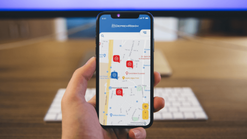
Deprem Hasar Tahmin Uygulaması: Depremriskim

Başarsoft tarafından geliştirilen DepremRiskim, binanın zarar görebilirliğine ilişkin bir tahmin raporu oluşturulabilmesi için geliştirilmiş, bir deprem hasar tahmin uygulaması olarak faaliyet gösteriyor. DepremRiskim, binanın zarar görebilirliğine ilişkin bir tahmin raporu oluşturulabilmesi için geliştirilmiş, bir deprem hasar tahmin uygulaması olarak faaliyet gösteriyor. Uygulamada zemin ile ilgili resmî gazetede depremsellikle ilgili yayınlanmış veriler (E-devlet’te 2018 yılında yayınlanan ...
webrazzi.com
Two New Drone LidarImagery Systems From TrueView

Two New Drone Lidar/Imagery Systems From TrueView

From the floor of Geo Week 2023, LiDAR mapping hardware & software company GeoCue announced new products for geospatial professionals. Frank Darmayan, CEO of GeoCue explains “Our new TrueView 535 builds upon the success of our best-selling TrueView 515 with several improvements; the upgraded LiDAR sensors adds a 3rd return which increases our ability to ...
amerisurv.com

Ursa Space Launches Python Toolbox API On Esri ArcGIS Pro

Ursa Space Systems announced the release of a Python toolbox for satellite analytics and data ordering within Esri ArcGIS Pro, a full-featured professional desktop GIS application. Ursa Space leverages the world’s most comprehensive and progressive satellite data virtual constellation, comprising synthetic aperture radar (SAR), Optical, and radio frequency (RF) sensing from multiple commercial sources and ...
geospatialworld.net

Missouri 911 Service Board Initiates First Ever 6-inch Resolution Statewide Imagery Program With Extensive Buy-up Options

Recognizing the importance to public safety and to many other government operations of high-quality aerial imagery, the Missouri 911 Service Board has partnered with the Department of Conservation, the Department of Natural Resources, and the Missouri GIS Advisory Council to launch a statewide imagery collection program. The imagery will be available at no charge through ...
businesswire.com

Maxar Signs Agreement With Umbra For Direct Access To Radar Imaging Satellites

Maxar has signed a contract with satellite imagery startup Umbra to get dedicated access to the company’s radar imaging constellation, the companies announced Feb. 14. The partnership will allow Maxar to directly task Umbra’s satellites and integrate synthetic aperture radar (SAR) data into its portfolio of Earth intelligence products and services, Tony Frazier, head of ...
spacenews.com

Air Quality Map For Dublin City Released As Part Of Google’s Project Air View

Dublin City Council has launched the results of Google’s Project Air View initiative, which measured the air quality of Dublin City’s streets over a period of 16 months and gathered over 50 million pieces of data. The project was delivered in partnership with the City Council’s Smart Dublin programme, with data captured by Google’s first ...
techcentral.ie