Geomaticians

22

Pomysły Na Internetową Mapę Dolnego Śląska Znów Poszukiwane

Pomysły Na Internetową Mapę Dolnego Śląska Znów Poszukiwane

Celem wydarzenia jest propagowanie rozwiązań systemów informacji geograficznej i Geoportalu Dolny Śląsk, wzbogacenie procesu nauczania treścią GIS oraz zwiększenie wiedzy na temat regionu. Konkurs skierowany jest do uczniów szkół średnich oraz studentów dziennych uczelni wyższych dowolnych kierunków. Jego przedmiotem jest opracowanie mapy obejmującej teren Dolnego Śląska, przedstawiającej dowolne aspekty przestrzeni odnoszące się do środowiska naturalnego ...
geoforum.pl
Wasserknappheit In Iran Ist Hausgemacht

Wasserknappheit In Iran Ist Hausgemacht

Forschende des Deutschen GeoForschungsZentrums GFZ haben zusammen mit Kolleg:innen der Universität Stuttgart und des Karlsruher Instituts für Technologie KIT die Entwicklung der letzten zwanzig Jahre für den gesamten Iran nachgezeichnet. Die Studie erschien kürzlich in der Fachzeitschrift Scientific Reports. Das Team nutzte dafür ausschließlich global verfügbare Datensätze, u.a. MODIS-Satellitenzeitreihendaten, Daten der GRACE/-FO-Satellitenmissionen und ERA5-Reanalyse-Klimadaten. Für ...
gfz-potsdam.de

یافته محققان دانشکده جغرافیا دانشگاه تهران درباره تأثیر منفی پدیده سایه بر روی داده‌های دریافتی از تصاویر ماهواره‌ای

به گزارش روابط عمومی دانشگاه تهران، گروهی از محققان دانشگاه تهران در پژوهشی به سرپرستی دکتر سید کاظم علوی‌پناه نشان دادند که سایه اثرات منفی قابل ملاحظه‌ای بر اطلاعات خصوصیات سطح زمین استخراج شده از تصاویر ماهواره‌ای می‌گذارد. وی با بیان اینکه بررسی اثرات پدیده سایه بر روی داده‌های دریافتی از تصاویر ماهواره‌ها حاصل یک ...
news.ut.ac.ir
Andalucía Dispone De Un Mapa De Minerales Críticos Claves Para El Desarrollo De Las Tecnologías Limpias

Andalucía Dispone De Un Mapa De Minerales Críticos Claves Para El Desarrollo De Las Tecnologías Limpias

El nuevo mapa de los minerales críticos existentes en el territorio de Andalucía, el primero de estas características en España, ofrece una fotografía actualizada de las materias primas que resultan fundamentales en el desarrollo de las nuevas tecnologías limpias. La herramienta identifica en suelo andaluz zonas susceptibles de aprovechamiento de 17 sustancias consideradas estratégicas en ...
smartgridsinfo.es

OGC Seeks Public Comment On Extension To SensorThings API Standard, StAplus 1.0

The Open Geospatial Consortium (OGC) is seeking public comment on STAplus 1.0. STAplus is an extension to the OGC SensorThings API Part 1: Sensing Version 1.1 (STA) Standard data model that is based on requirements from the Citizen Science community. Comments are due by March 23, 2023. STAplus (SensorThings API extension PLUS) defines a SensorThings ...
directionsmag.com

OGC Seeks Public Comment On V3.0 Of GeoXACML And Related JSON Profile

The Open Geospatial Consortium (OGC) seeks public comment on version 3.0 of the OGC Geospatial eXtensible Access Control Markup Language (GeoXACML) Standard and its related JSON Profile (v1.0). Comments are due by March 23, 2023. The OGC Geospatial eXtensible Access Control Markup Language (GeoXACML) 3.0 Standard is a geospatial extension to the OASIS eXtensible Access ...
directionsmag.com
Orbify Has Now Opened Its Platform To Everyone

Orbify Has Now Opened Its Platform To Everyone

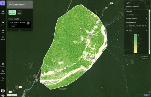
Orbify is a SaaS platform that enables the creation of custom Earth Intelligence web applications, dashboards, or APIs. Platform users can combine three different components that allow for the easy creation of these applications: data, algorithms, and visual components necessary for a front-end web application that is presented to the end user. Everything is cloud-based, ...
geoweeknews.com

NASA Leveraging TerraPoiNT For BVLOS UAM Testing In GPS-denied Environments

NASA’s Ames Research Center will leverage NextNav’s TerraPoiNT commercial grade network to capture inflight data on drone navigation, detection and collision avoidance as part of BVLOS testing for its urban air mobility (UAM) program. Via a network of terrestrial beacons, TerraPoiNT provides precise geolocation services when GPS signals aren’t available. NASA will use TerraPoiNT to ...
insidegnss.com

US Aerospace Firm Lockheed Martin Space Looking To Work With ISRO, Indian Pvt Space Sector

American defence-aerospace firm Lockheed Martin’s Space division has been in talks with the Indian Space Research Organisation (ISRO) and the emerging Indian private space sector for collaboration, said a top official. This is a result of India’s space sector being reformed to permit private firms to carry out end-to-end space activities and seek government support ...
wionews.com
Restoration Of Hatay's Damaged Landmarks Made Via 3D Modeling

Restoration Of Hatay’s Damaged Landmarks Made Via 3D Modeling

Teams from Istanbul University started their investigations of historical buildings that were severely damaged. Working in separate groups in the field, the teams make measurements using the photogrammetry technique with the help of drones and performing lidar mapping. “… The first step is the three-dimensional (3D) visualization of the surrounding buildings and the most important ...
dailysabah.com