Geomaticians

14

Bluesky Geospatial Launches MetroVista 3D Aerial Mapping Program In U.S.

Bluesky Geospatial Launches MetroVista 3D Aerial Mapping Program In U.S.

Bluesky Geospatial Ltd. has announced the launch of its MetroVista 3D aerial mapping program in the United States. The service employs a hybrid imaging-LiDAR airborne sensor to capture highly detailed 3D data, including 360-degree views of buildings and street-level features, in urban areas for use in creating digital twins, visualizations, and simulations. Bluesky’s sister company, ...
amerisurv.com
Mapping Of No-drill Areas In Ecuador’s Amazon Can Be Scaled For Entire Rainforest Study

Mapping Of No-drill Areas In Ecuador’s Amazon Can Be Scaled For Entire Rainforest: Study

In 2007, Ecuador’s then-president, Rafael Correa, announced an ambitious plan to prevent oil drilling in Yasuní National Park, one of the world’s most biodiverse areas and home to the Indigenous Waorani people, 4,000 plant species, and 300 mammal species, several of them threatened. Correa called on other countries to help Ecuador keep the area intact, ...
news.mongabay.com
Mapping Rwanda’s Trees From Above

Mapping Rwanda’s Trees From Above

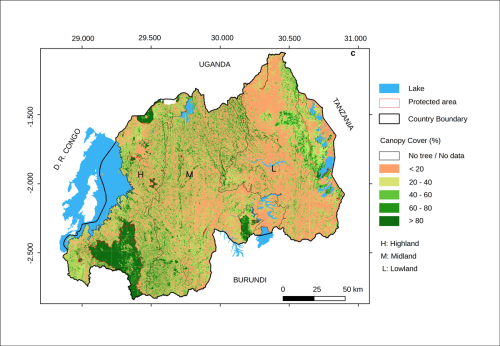
Aerial photos taken high above Rwanda are helping scientists monitor trees and determine how much carbon is locked in the verdant resource. The approach, detailed in a newly published study, revealed that most of the country’s trees lie outside its forests, although conservation and reforestation efforts need to address all ecosystems. Inside or outside forests, ...
eos.org