Geomaticians

02

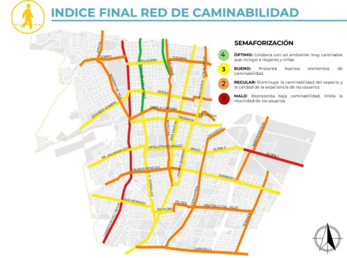
Godoy Cruz Creó Un Sistema Que Ayuda A Elegir Los Mejores Recorridos Para Trasladarse Caminando

Godoy Cruz Creó Un Sistema Que Ayuda A Elegir Los Mejores Recorridos Para Trasladarse Caminando

Durante un año y medio de trabajo, desarrollado junto a la Facultad de Ingeniería de la Uncuyo, se analizó y diagnosticó la situación de caminabilidad. Esto es, cuánto se demora una persona en llegar a sus actividades de forma peatonal. Y qué tan amigable es una zona. Para el desarrollo de dicho indicador, se tuvieron ...
losandes.com.ar

OGC To Form GeoDcat Standards Working Group; Public Comment Sought On Draft Charter

The Open Geospatial Consortium (OGC) is in the process of forming a new GeoDCAT Standards Working Group (SWG). Public comment is sought on its draft charter. Comments are due by February 22, 2023. The purpose of the SWG is to revise, publish, and maintain GeoDCAT – a spatio-temporal profile of the W3C DCAT Recommendation – ...
directionsmag.com

IBM, NASA Collaborate For Climate Change Research

IBM and NASA are collaborating for initiating improved climate change research. It was announced on February 1, that IBM is going to work together with NASA’s Marshall Space Flight Center to use artificial intelligence for climate change research in an effort to greatly improve research analysis of these large datasets. The aim is to make ...
geospatialworld.net
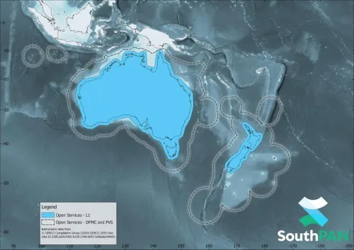
New Satellite-based Augmentation System For Australia And New Zealand

New Satellite-based Augmentation System For Australia And New Zealand

AMSA informed that vessels navigating in Australian and New Zealand waters can now access a Satellite-Based Augmentation System (SBAS) called SouthPAN. SouthPAN provides accurate, reliable and instant augmentation of PNT information across all of Australia and New Zealand. For example, the horizontal accuracy provided is several times better than the current unaugmented GNSS accuracy of ...
safety4sea.com

Esri Signs Space Act Agreement With NASA

The agreement focuses on extending access to the broader global community of NASA’s geospatial content for continued research and exploration—including new datasets from nearly 100 spaceborne sensors, measuring atmospheric health, land-based phenomena, and characteristics of the oceans. Partner efforts under this agreement will add to the existing NASA data in ArcGIS Living Atlas of the ...
geospatialworld.net