Geomaticians

01

New RIEGL UAV-Lidar Scanning Solution Ready For Take-Off

RIEGL has recently added the VUX-18024, a lightweight and versatile UAV-Lidar sensor for high-speed surveying missions, to its portfolio. This once again underlines the Austrian company’s pioneering role as a provider of high-performance Lidar sensors and systems for integration with unmanned aerial systems (UASs). The new RIEGL VUX-18024 offers a wide field of view of ...
gim-international.com

Trimble Supports Indian Institute Of Technology With Inertial Navigation Solutions For UAV Industry Leadership

Trimble announced today a collaboration with the Indian Institute of Technology in Kanpur (IIT Kanpur) to support a new program in uncrewed aerial vehicles (UAV) to be offered by the Department of Aerospace Engineering. A signing ceremony to officially launch the program was held on October 26 and attended by Professor Tarun Gupta, dean of ...
uasweekly.com

IBM Advances Geospatial AI To Address Climate Challenges

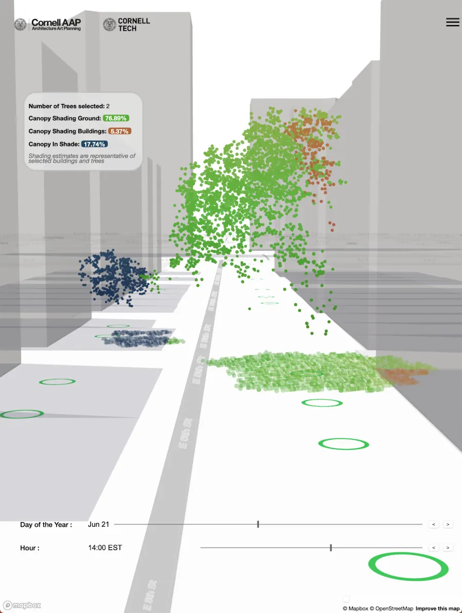
IBM today announced new efforts that apply its geospatial AI technologies, including IBM’s geospatial foundation model developed in collaboration with NASA, to climate efforts including analysis of urban heat islands in the United Arab Emirates (UAE); reforestation across Kenya; and climate resiliency in the United Kingdom (UK). IBM continues to advance its AI model strategy ...
newsroom.ibm.com

Datos Satelitales Abiertos Permiten Desarrollar Modelo Que Conecta Polinización Y Terrenos Con Potencial Agrícola

Un innovador estudio que utiliza datos satelitales abiertos ayudará a desarrollar un modelo que integra la presencia de insectos polinizadores y la restauración de predios agrícolas. El estudio es de Laura Pérez, doctora en Ecología y Biología Evolutiva y postdoctorante de Data Observatory, Centro ANID, quien desarrolla hasta el 2025 esta investigación para una mejor ...
diariolagoranco.cl
Satellite Imagery Analysis Firm Launches Free Greenhouse Gas Tracker

Satellite Imagery Analysis Firm Launches Free Greenhouse Gas Tracker

French satellite imagery analysis provider Kayrros launched a free version of its global methane tracking map Nov. 29 to help hold governments and businesses to account for their emissions. The public platform uses data from the European Space Agency’s Sentinel-5P satellite and a sensor on the International Space Station to provide daily snapshots of the ...
spacenews.com
New York Will Plant Thousands Of Trees Using New Tech To Maximize Foliage Impact

New York Will Plant Thousands Of Trees Using New Tech To Maximize Foliage Impact

New York City is poised to get a lot more trees. Last month, the city council passed a measure calling for 30% canopy cover by 2035, up from its current cover of 22% – which could mean 250,000 new trees. More trees, with all their cooling benefits, is a clear win for the environmental justice ...
theguardian.com
Satellite Remote Sensing Model For Wide-Area Prediction Of Transpiration Rates In Japanese Cypress Plantations

Satellite Remote Sensing Model For Wide-Area Prediction Of Transpiration Rates In Japanese Cypress Plantations

Forests, known as nature’s “green dams,” play a crucial role in replenishing Earth’s groundwater reserves. However, overcrowding in planted forests due to lack of maintenance activities, such as thinning practices, is a pressing concern in Japan. This overcrowding causes substantial water loss from these forests into the atmosphere through a combination of soil evaporation and ...
phys.org
Researchers Propose New Method for Large-Scale Urban Building Function Mapping Using Web-Based Geospatial Data

Researchers Propose New Method for Large-Scale Urban Building Function Mapping Using Web-Based Geospatial Data

In a pioneering study published in Geo-spatial Information Science, a research group led by Yuyu Zhou from The University of Hong Kong developed an integrated framework that achieves 94% accuracy in mapping building functions across 50 U.S. cities using multi-source web-based geospatial data, offering potential for worldwide application. The team utilized TripAdvisor.com and Google Maps ...
newswise.com